
Posted on 02/25/2025 9:14:27 AM PST by Red Badger
Artist's depiction of an Earth-like beach on Mars. (© Prasa-gg - stock.adobe.com)
=================================================================
In a nutshell
* Chinese Zhurong rover discovered underwater layers of sediment beneath the Martian surface that closely resemble Earth’s coastal beach deposits, providing the strongest evidence yet for an ancient ocean on Mars.
* The beach-like formations extend continuously for over 1.3 kilometers, indicating a stable, long-lived body of water rather than temporary flooding — essentially a “vacation-style beach” that existed for tens of millions of years.
* This discovery suggests Mars once had a complex water system with rivers, waves, and ocean currents that could have created environments potentially habitable for microbial life.
=================================================================
GUANGZHOU, China –– Mars wasn’t always the dusty red desert we know today. Billions of years ago, waves may have crashed against sandy beaches under an alien sky, while rivers carried sediments into a vast northern ocean. This isn’t science fiction—it’s the compelling picture emerging from a discovery announced today.
Chinese scientists, using ground-penetrating radar from the Zhurong rover, have uncovered what appears to be ancient beach deposits buried beneath the Martian surface, providing the strongest evidence yet that Mars once had Earth-like coastlines and a massive ocean.
Published in the Proceedings of the National Academy of Sciences, this study reveals distinct layer patterns buried under the planet’s surface at Utopia Planitia, where Zhurong landed in May 2021.
Vacation-Style Beaches on the Red Planet
Intriguingly, these patterns resemble coastal deposits found on Earth’s shorelines. The structure and consistency of these buried layers align with patterns observed in foreshore sedimentation on Earth, where waves deposit sediments over time.
“We’re finding places on Mars that used to look like ancient beaches and ancient river deltas,” said Benjamin Cardenas, assistant professor of geology at Penn State and co-author of the study, in a statement. “We found evidence for wind, waves, no shortage of sand — a proper, vacation-style beach.”
The study suggests that these features most likely formed in a stable, long-lived body of water rather than being the result of short-term flooding or isolated melt events.

A hypothetical picture of Mars 3.6 billion years ago, when an ocean may have covered nearly half the planet. The blue areas show the depth of the ocean filled to the shoreline level of the ancient, now-gone sea, dubbed Deuteronilus. The orange star represents the landing site of the Chinese rover Zhurong. The yellow star is the site of NASA’s Perseverance rover, which landed a few months before Zhurong. (Credit: Robert Citron)
======================================================================
Seeing Beneath the Surface: How the Discovery Was Made
For decades, scientists have debated whether Mars once hosted oceans. While orbital imagery has suggested potential shorelines, variations in their elevations made this evidence controversial. Some features initially thought to be ancient coastlines were later explained by lava flows or aeolian processes.
The new radar evidence provides a fresh perspective by peering beneath the surface, where geological structures remain better preserved from billions of years of erosion, impacts, and dust storms.
Zhurong, part of China’s Tianwen-1 mission, landed on southern Utopia Planitia on May 15, 2021. Before entering hibernation in May 2022, it traveled 1.921 kilometers across the Martian surface, collecting scientific data with its instruments, including the Rover Penetrating Radar (RoPeR).
This radar system, operating at 15-95 MHz, enabled scientists to detect structures as deep as 100 meters below the surface. After careful processing, researchers identified 76 subsurface dipping reflectors, all inclining toward the northern lowlands.

Map highlighting the dense gravitational structures in the northern hemisphere. The regions denoted by the black lines are high mass anomalies that do not show any correlation with geology and topography. These hidden subsurface structures are covered by sediments from an old ocean. Their origin is still a mystery and a dedicated gravity mission, like MaQuIs, is needed to reveal their nature. (Credit: Root et al.)
================================================================================
Earth-Like Coastal Features
The team compared these angles with radar data from 21 different coastal areas on Earth and found striking similarities. On Earth, such dipping layers typically form as waves deposit sediments at shorelines, advancing or retreating coastlines over time.
“This stood out to us immediately because it suggests there were waves, which means there was a dynamic interface of air and water,” Cardenas said.
These results align with previous research that identified possible marine sedimentary rocks ejected by meteorite impacts near the rover’s landing site.
Ruling Out Alternative Explanations
The research team carefully considered other potential explanations for these subsurface features.
Lava flows were ruled out because the measured permittivity (how well a material transmits electric fields) of the layers averages 4.4, significantly lower than volcanic deposits, which typically measure around 9. This makes a volcanic origin unlikely.
Wind-blown sand dunes were also dismissed because aeolian deposits usually exhibit varying inclination angles and cross-bedding, neither of which appeared in the radar data.

On Earth, ocean tides and winds carry sediment toward the shoreline, where the sediment settles out to form a beach deposit with a characteristic dipping angle. New observations indicate that early in its history, Mars also had an open ocean with tides and wind-driven waves that deposited sediment on the beach. (Credit: Hai Liu, Guangzhou University, China)
==========================================================================
The possibility of river deposits was considered but found unlikely since the landing site lacks clear evidence of fluvial features such as valley networks.
The study concludes that these deposits are most consistent with ancient coastal sedimentary structures, likely composed of sand and pebble gravels transported by waves and currents in an ancient Martian ocean.
Implications for Mars’ Past Climate and Habitability
This discovery strengthens the hypothesis that Mars’ northern plains once hosted a large and persistent ocean. The thickness and continuous extent of these deposits suggest that liquid water existed for an extended period, potentially tens of millions of years.
“We’re seeing that the shoreline of this body of water evolved over time,” Cardenas said. “We tend to think about Mars as just a static snapshot of a planet, but it was evolving. Rivers were flowing, sediment was moving, and land was being built and eroded.”
This timeframe aligns with other evidence suggesting that Mars experienced a warmer, wetter climate during the Late Hesperian period (approximately 3 to 3.5 billion years ago). Such conditions would have been more favorable for potential microbial life.
The presence of these deposits suggests that Mars once had a functioning hydrological cycle, with rivers transporting sediments into an ocean basin.

Schematic showing how a series of beach deposits would have formed at the Zhurong landing site in the distant past on Mars (left) and how long-term physical and chemical weathering on the planet altered the properties of the rocks and minerals and buried the deposits. (Credit: Hai Liu, Guangzhou University, China)
=========================================================================
Interestingly, some less prominent radar reflectors dip in the opposite direction, forming dome-like structures interpreted as ancient beach ridges, where waves once reached their maximum height before retreating.
These findings also provide an explanation for previous orbital observations of paleoshorelines at varying elevations. While these variations initially cast doubt on the ocean hypothesis, processes such as true polar wander (shifts in Mars’ rotation axis) and crustal deformation from volcanic activity may have altered shoreline elevations over time.
Rewriting Our Understanding of Mars
“The capabilities of the Zhurong rover have allowed us to understand the geologic history of the planet in an entirely new way,” said Michael Manga, professor of Earth and planetary science at UC Berkeley.
With Zhurong’s direct subsurface observations, we now have on-the-ground evidence that complements orbital studies and strengthens the case for at least one major oceanic period in Mars’ history.
This discovery carries profound implications for Mars’ habitability. On Earth, coastal environments are highly favorable for life, offering nutrients, energy gradients, and protected niches where primitive organisms can thrive. If similar conditions existed on ancient Mars, they might have been conducive to microbial life.
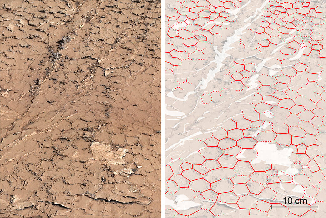
In a previous study, NASA’s Curiosity’s Mastcam at “Pontours” reveals hexagonal patterns – outlined in red in the same image, right – that suggest these mud cracks formed after many wet-dry cycles occurring over years. Credits: NASA/JPL-Caltech/MSSS/IRAP
========================================================================
While the Zhurong rover was not equipped to search for biosignatures, its findings help narrow down promising locations for future missions seeking signs of past life.
The study also raises questions about what happened to Mars’ ancient ocean. Did it escape to space as the planet’s atmosphere thinned? Does some remain frozen underground? Could deep groundwater still exist beneath Mars’ surface? These questions will likely drive the next generation of Mars exploration.
For now, this research offers a remarkable glimpse into Mars’ past—a time when waves lapped at shorelines, rivers flowed into an ocean, and the Red Planet may have looked strikingly Earth-like.
Ping!.....................What’s next? Timeshares?..............

Mars may have had open water for a brief period of its history. It’s low gravity and tiny magnetosphere meant a planet that could not keep a waterey environment for very long.
The main thing is to be able to get enough manpower onto Mars, get underground and activate the alien-created oxygenation machine to fix the atmosphere. Then we can worry about restoring the beaches. But in the meantime we can ship everyone in Gaza there as an advance scouting team.
Cool!
Didn’t John Carter of Virginia map these oceans?
Paging Immanuel Velikovsky.
Getting to that machine is the hard part.


I wonder if the same water from the heavens mentioned in Genesis was from asteroids that our solar system intercepted which could have showered more than just earth.
Finally got rid of ours. Not getting another even at pre construction pricing. 😂👍
 This picture is from the result of the Lake Missoula flood that ripped through Montana, Idaho, and Washington some 12,000 years ago. I would expect to see pictures like this from Mars if it also experienced ice ages which formed dams which then broke loose during warming ages
Amazing! How did you get a picture from 12,000 years ago?
Not to mention an average temperature of -85 Fahrenheit. Nonsense.
USAID gave me a grant to develop Time travel.
So you’re the one who beat me to the grant money for the Time Travel Project. Congratulations. I was just going to tinker around some electronic stuff and fritter the money away.
He used a 12,000 year-old camera, Silly.
Disclaimer: Opinions posted on Free Republic are those of the individual posters and do not necessarily represent the opinion of Free Republic or its management. All materials posted herein are protected by copyright law and the exemption for fair use of copyrighted works.