Posted on 07/25/2004 12:36:29 AM PDT by Yosemitest
|
Ship-sinking monster waves revealed by ESA satellites
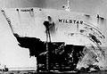
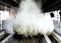
Once dismissed as a nautical myth, freakish ocean waves that rise as tall as ten-storey apartment blocks have been accepted as a leading cause of large ship sinkings. Results from ESA's ERS satellites helped establish the widespread existence of these 'rogue' waves and are now being used to study their origins. Severe weather has sunk more than 200 supertankers and container ships exceeding 200 metres in length during the last two decades. Rogue waves are believed to be the major cause in many such cases. Mariners who survived similar encounters have had remarkable stories to tell. In February 1995 the cruiser liner Queen Elizabeth II met a 29-metre high rogue wave during a hurricane in the North Atlantic that Captain Ronald Warwick described as "a great wall of water… it looked as if we were going into the White Cliffs of Dover." And within the week between February and March 2001 two hardened tourist cruisers – the Bremen and the Caledonian Star – had their bridge windows smashed by 30-metre rogue waves in the South Atlantic, the former ship left drifting without navigation or propulsion for a period of two hours.
"The same phenomenon could have sunk many less lucky vessels: two large ships sink every week on average, but the cause is never studied to the same detail as an air crash. It simply gets put down to 'bad weather'." Offshore platforms have also been struck: on 1 January 1995 the Draupner oil rig in the North Sea was hit by a wave whose height was measured by an onboard laser device at 26 metres, with the highest waves around it reaching 12 metres.
The fact that rogue waves actually take place relatively frequently had major safety and economic implications, since current ships and offshore platforms are built to withstand maximum wave heights of only 15 metres. In December 2000 the European Union initiated a scientific project called MaxWave to confirm the widespread occurrence of rogue waves, model how they occur and consider their implications for ship and offshore structure design criteria. And as part of MaxWave, data from ESA's ERS radar satellites were first used to carry out a global rogue wave census.
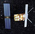
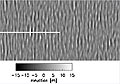
ESA's twin spacecraft ERS-1 and 2 – launched in July 1991 and April 1995 respectively – both have a Synthetic Aperture Radar (SAR) as their main instrument. The SAR works in several different modes; while over the ocean it works in wave mode, acquiring 10 by 5 km 'imagettes' of the sea surface every 200 km.
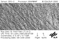
"The raw imagettes are not made available, but with their resolution of ten metres we believed they contained a wealth of useful information by themselves," said Rosenthal. "Ocean wave spectra provide mean sea state data but imagettes depict the individual wave heights including the extremes we were interested in. "ESA provided us with three weeks' worth of data – around 30,000 separate imagettes – selected around the time that the Bremen and Caledonian Star were struck. The images were processed and automatically searched for extreme waves at the German Aerospace Centre (DLR)."
"Having proved they existed, in higher numbers than anyone expected, the next step is to analyse if they can be forecasted," Rosenthal added. "MaxWave formally concluded at the end of last year although two lines of work are carrying on from it – one is to improve ship design by learning how ships are sunk, and the other is to examine more satellite data with a view to analysing if forecasting is possible." A new research project called WaveAtlas will use two years worth of ERS imagettes to create a worldwide atlas of rogue wave events and carry out statistical analyses. The Principal Investigator is Susanne Lehner, Associate Professor in the Division of Applied Marine Physics at the University of Miami, who also worked on MaxWave while at DLR, with Rosental a co-investigator on the project.
"Looking through the imagettes ends up feeling like flying, because you can follow the sea state along the track of the satellite," Lehner said. "Other features like ice floes, oil slicks and ships are also visible on them, and so there's interest in using them for additional fields of study. "Only radar satellites can provide the truly global data sampling needed for statistical analysis of the oceans, because they can see through clouds and darkness, unlike their optical counterparts. In stormy weather, radar images are thus the only relevant information available." So far some patterns have already been found. Rogue waves are often associated with sites where ordinary waves encounter ocean currents and eddies. The strength of the current concentrates the wave energy, forming larger waves – Lehner compares it to an optical lens, concentrating energy in a small area.
However the data show rogue waves also occur well away from currents, often occurring in the vicinity of weather fronts and lows. Sustained winds from long-lived storms exceeding 12 hours may enlarge waves moving at an optimum speed in sync with the wind – too quickly and they'd move ahead of the storm and dissipate, too slowly and they would fall behind. "We know some of the reasons for the rogue waves, but we do not know them all," Rosenthal concluded. The WaveAtlas project is scheduled to continue until the first quarter of 2005. Related news ERS-2 has new role 'nowcasting' Europe's weather ESA's orbiting hurricane hunter back in action
In depth
Related links
|
Seiching is the formation of standing waves in water body, due to wave formation and subsequent reflections from the ends. These waves may be incited by earthquake motions (similar to the motions caused by shaking a glass of water), impulsive winds over the surface, or due to wave motions entering the basin. The various modes of seiching correspond to the natural frequency reponse of the water body.
In this example, a rectangular basin (of infinite width) with given length and depth is seiching in accordance with the mode that you specified (greater than zero). The period of seiching (T) is determined by finding the correct length wave that will fit in the basin for the given water depth (based on linear water wave theory). The percent refers to the difference between the seiching period predicted by the dispersion relationship versus that usually used: shallow water theory.
(For shallow water theory, the seiching period is given by twice the basin length (l) divided by the modal number (n) and the speed of a shallow water wave (which depends on the water depth h)
As an example, try a basin of length 100 m, a depth of 20 m, and a mode number of two. Note that the water surface motion is out of phase with the velocities (shown with white lines). Also notice that the water motions do not have the elliptical orbits as progressive waves do (as in the Linear Kinematics applet). Under a node (no displacement of the water surface), the velocity is always horizontal, while under an antinode (max. displacement), the velocity is vertical. Further, this example (with quite a large water depth) gives quite a discrepancy between the linear theory result of the applet and the shallow water theory.
In the figure, you will notice that the number of modes corresponds to the number of nodal points (points of no motion of the water surface).
There are an infinite number of seiching modes possible, from the lowest (mode 1) to infinity. The period of oscillation decreases with mode number. Realistically, the lower modes probably occur in nature, as frictional damping affects the higher modes preferentially (higher frequency).
The seiching calculations for linear theory are given in Chapter 4 and 5 of Dean and Dalrymple, Water Wave Mechanics for Engineers and Scientists, World Scientific Press.)
But you would have to spell it:-Remonstorate.
wow
"Reporters, surfers, and normal people look and a wave and think of the height as being from the top to the bottom -- makes sense but that can turn a '29-metre' wave into a '58-metre' wave."
Missleading at it's best!
I brought nback a 38' sailboat from the Istmus of Catalina to San Pedro in a whole gale that had been blowing for 3 days and the trough to peak of the waves was 50-70' which in a storm isn't that unusual in the Catalina channel.
It was a pretty exciting trip, the 25 miles was covered in an hour and 46 minutes, almost power boat speed.
Shackleton survived such a massive wave on his small boat trip to S. Georgia. Damage from a 1400 foot splash, after a landslide in Alaska, was reported on the Mega-Tsunami TV show on (?) Discovery channel.
bump
"King" waves we call them... known to pluck fishermen off high cliffs on the west coast of Australia. They even have signs posted..."Beware of King Waves".
If Bush had supported the Kyoto Treaty, these waves would never happen. /sarcasm
If I owned one of those two ships I would just beach it and try to sell it for scrap. Every week? That has to be beyond annoying.
http://www.freerepublic.com/focus/f-news/1177972/posts
goon = gonna
How can they beware of them? By the time they see one coming, it's probably too late to run very far.
right- beware of standing too near the edge of the cliffs... just in case ya know!
Please FREEPMAIL me if you want on, off, or alter the "Gods, Graves, Glyphs" PING list --
Archaeology/Anthropology/Ancient Cultures/Artifacts/Antiquities, etc.
The GGG Digest -- Gods, Graves, Glyphs (alpha order)
|
· join list or digest · view topics · view or post blog · bookmark · post a topic · subscribe · |
|||
Antiquity Journal & archive Archaeologica Archaeology Archaeology Channel BAR Bronze Age Forum Discovery Dogpile Eurekalert LiveScience Mirabilis.ca Nat Geographic PhysOrg Science Daily Science News Texas AM Yahoo Excerpt, or Link only? |
|
||
|
· Science topic · science keyword · Books/Literature topic · pages keyword · |
|||
Note: this topic is from 7/22/2004.
|
|
· join list or digest · view topics · view or post blog · bookmark · post a topic · subscribe · |
|||
Antiquity Journal & archive Archaeologica Archaeology Archaeology Channel BAR Bronze Age Forum Discovery Dogpile Eurekalert LiveScience Mirabilis.ca Nat Geographic PhysOrg Science Daily Science News Texas AM Yahoo Excerpt, or Link only? |
|
||
|
· Science topic · science keyword · Books/Literature topic · pages keyword · |
|||
Disclaimer: Opinions posted on Free Republic are those of the individual posters and do not necessarily represent the opinion of Free Republic or its management. All materials posted herein are protected by copyright law and the exemption for fair use of copyrighted works.