 From what I hear about the road to Chaco, this has much easier access.
Posted on 07/03/2009 5:09:44 AM PDT by SunkenCiv
From the sky, the Mound of the Cross at Paquime, a 14th-century ruin in the Mexican state of Chihuahua, looks like a compass rose -- the roundish emblem indicating the cardinal directions on a map. About 30 feet in diameter and molded from compacted earth and rock taken near the banks of the Casas Grandes River, the crisscross arms point to four circular platforms. They might as well be labeled N, S, E and W...
(Excerpt) Read more at stltoday.com ...
|
|
|||
Gods |
AP source, so the excerpt is lousy. :') Basically, I'm not entirely impressed with the thought process behind this claim, but it should at least be good for some levity. |
||
|
· Discover · Nat Geographic · Texas AM Anthro News · Yahoo Anthro & Archaeo · Google · · The Archaeology Channel · Excerpt, or Link only? · cgk's list of ping lists · |
|||
Migration more like invasion the trash trail from Mexiico to the U.S. is a wide one.
I spent the night in Chaco.....awesome.
I hope to go again, this time having read more of Steve Lekson’s books. I sorted through the books at the Chaco Park Service store and found that his on the Chaco Meridian seemed to make the most sense.
I can’t describe the feeling of visiting the village of Oraibi on the Hopi Mesa where the people have been living continuously for 900 years. The village is believed to have been settled after the departure fron Chaco
I remember taking a class in college on Latin American immigrants in the US. The professor (from Puerto Rico) asked the first day of class what the oldest settlement was in the US. He expected people to say Jamestown or Plymouth, and he’d pull the ‘gotcha’ St Augustine card. Most students obliged him.
I told him Old Oraibi on the Hopi mesas. He was flummoxed.
Being a trained archaeologist who worked in the SW, I am chagrined to say I’ve never been to Chaco. All my cars were of the sporty variety and that road in would have ripped the oil pans from them.
Further, when you visit Santa Fe, they will lay it all out.....Santa Fe predate the invasion at St Agustine to capture Fort Caroline, a French colony just to the north at the river of May, Jscksonville/Mayport.
From what I hear about the road to Chaco, this has much easier access.
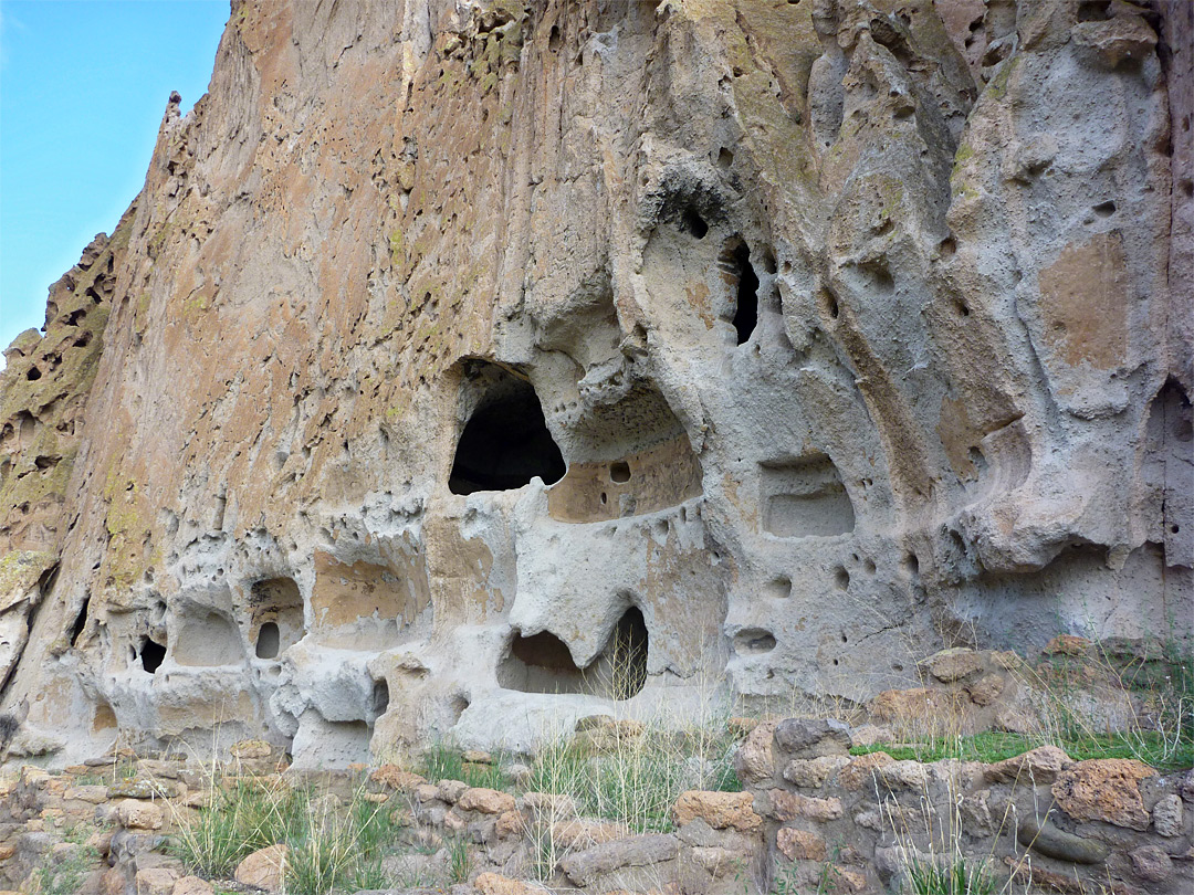
Frijoles canyon... looks like they were busy for a while!
Que?
Lotta holes dug all over that cliff face.
I think thats what gave them the idea, those holes are naturally occuring. (the smaller ones are all over the cliff faces)
“Lava: Frijoles Canyon has been created by Frijoles Creek, eroding through thick deposits of volcanic rock - mainly tuff, which is full of natural cavities - originally air pockets in ash deposits from volcanic eruptions several thousand years ago. These may be several meters in diameter, and were used by the Anasazi peoples between 700 and 450 years ago as the basis of their villages. Selected cavities were enlarged, linked together and augmented to form clusters of dwellings in many places over several miles of this rocky land southeast of the Jemez Mountains. The ash originated from volcanoes at the site of Valle Grande Peak, a few miles to the west. Various hot springs in the nearby forests still hint of continuing thermal activity. Together with some more conventional ruins along the canyon floor, many of these unusual dwellings are just a short walk away from the Monument visitor center, and a 2 mile loop path allows for easy viewing.”
http://www.americansouthwest.net/new_mexico/bandelier/national_monument.html
Right near Los Alamos. Beautiful area, worth a visit, esp in Spring or Fall when you won’t have to wait for parking. The Tsankawi section is great to tromp around on. Lots of cavates carved into the volcanic tuff (which is what that photo displays). The particular one in the photo is called Long House in Frijoles Canyon, just up the trail from Tyounyi. I did quite a bit of research work in that area.
LA has a nice museum on the Manhattan Project and development of atomic/nuclear energy. LANL also has some nice sites that I’ve been to, but they are not normally open to the public.
They also mined the tuff for building material. A lot of the ruins there have tuff shaped into ‘bricks’ with mortar between them or cinking stones, then covered with lime or mud plaster.
The Pajarito Plateau is basically one large pyroclastic flow which solidified into volcanic tuff. If you do a google map on Los Alamos and zoom out you can see the caldera to the NW, the Valle Grande. Some of the tuff is 500+ feet thick—there were two major eruptions, so the total tuff is 1000 feet in places.
Hiking in Bandelier backcountry is also great, but bring very good hiking boots and be in good shape—at 6500-7000 feet altitude starts to become a factor for lowlanders like me. Alamo canyon will kick your butt if you try it the first few days in the area. And bring raingear: they have t-storms just about every afternoon July-Sep, some very violent.
My boots only lasted a month walking on that volcanic tuff. Wore the soles right through.
>>If you do a google map on Los Alamos and zoom out you can see the caldera to the NW, the Valle Grande.
Due West from Los Alamos, NW from Bandelier.
We were there last August and there had been a flash flood in the canyon a few days before. Scary place to be when that happens. (and it was raining 2 to 5 inches around the area)
We camped in the national forest adjacent to Valle Grande.
A Chaco meridian is as good an explanation as I've heard. You scratch your head wondering why a civilization would put a major city in a place with such marginal agriculture, water and wood.
Disclaimer: Opinions posted on Free Republic are those of the individual posters and do not necessarily represent the opinion of Free Republic or its management. All materials posted herein are protected by copyright law and the exemption for fair use of copyrighted works.