Skip to comments.
Exploring The Ocean Basins With Satellite Altimeter Data
National Geophysical Data Center, National Oceanic and Atmospheric Administration ^
| Tue Nov 25 2004 (apparently)
| David T. Sandwell and Walter H. F. Smith
Posted on 03/28/2005 10:10:48 AM PST by SunkenCiv
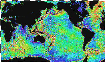
The reason that the ocean floor, especially the southern hemisphere oceans, is so poorly charted is that electromagnetic waves cannot penetrate the deep ocean (3-5 km = 2-3 mi). Instead, depths are commonly measured by timing the two-way travel time of an acoustic pulse. However because research vessels travel quite slowly (6m/s = 12 knots) it would take approximately 125 years to chart the ocean basins using the latest swath-mapping tools. To date, only a small fraction of the sea floor has been charted by ships. Fortunately, such a major mapping program is largely unnecessary because the ocean surface has broad bumps and dips which mimic the topography of the ocean floor... [B]ecause the earth is rotating, the equipotential ocean surface is more nearly matched by an ellipsoid of revolution where the polar diameter is 43 km less than the equatorial diameter. While this ellipsoidal shape fits the earth remarkably well, the actual ocean surface deviates by up to 100 meters from this ideal ellipsoid. These bumps and dips in the ocean surface are caused by minute variations in the earth's gravitational field
(Excerpt) Read more at ngdc.noaa.gov ...
TOPICS: History; Science; Travel
KEYWORDS: archaeology; astronomy; ggg; godsgravesglyphs; gravity; gravitypotato; history; miltech; potsdamgravitypotato; roguewave; roguewaves; science; seabed; seafloor; tsunami; tsunamis
This is related to today's 8.2 earthquake, the infamous predecessor with its tsunamis, precolumbian navigation, and underwater archaeology, among other things. Thought I'd seen this before on FR. A GGG ping.
FR Lexicon·Posting Guidelines·Excerpt, or Link only?·Ultimate Sidebar Management·Headlines
Donate Here By Secure Server·Eating our own -- Time to make a new start in Free Republic
PDF to HTML translation·Translation page·Wayback Machine·My Links·FreeMail Me
Gods, Graves, Glyphs topic·and group·Books, Magazines, Movies, Music
1
posted on
03/28/2005 10:10:54 AM PST
by
SunkenCiv
To: blam; FairOpinion; Ernest_at_the_Beach; 24Karet; 3AngelaD; 4ConservativeJustices; A.J.Armitage; ...
Please FREEPMAIL me if you want on, off, or alter the "Gods, Graves, Glyphs" PING list --
Archaeology/Anthropology/Ancient Cultures/Artifacts/Antiquities, etc.
The GGG Digest -- Gods, Graves, Glyphs (alpha order)
2
posted on
03/28/2005 10:13:39 AM PST
by
SunkenCiv
(last updated my FreeRepublic profile on Friday, March 25, 2005.)
To: SunkenCiv; Boot Hill
Probably wouldn't expose underwater seamounts though!
3
posted on
03/28/2005 10:27:08 AM PST
by
Ernest_at_the_Beach
(This tagline no longer operative....floated away in the flood of 2005 ,)
To: Ernest_at_the_Beach
To the west of the ridge lies the Louisville seamount chain which is a chain of large undersea volcanoes having a length equal to the distance between New York and Los Angeles. These features are unfamiliar because they were discovered less than 20 years ago. The Louisville seamount chain was first detected in 1972 using depth soundings collected along random ship crossings of the South Pacific. Six years later the full extent of this chain was revealed by a radar altimeter aboard the Seasat (NASA) spacecraft. Recently, high density data collected by the Geosat (US Navy) and ERS-1 (European Space Agency) spacecraft data show the Pacific-Antarctic Rise and the Louisville Ridge in unprecedented detail... We are using these dense satellite altimeter measurements in combination with sparse measurements of seafloor depth to construct a uniform resolution map of the seafloor topography. These maps do not have sufficient accuracy and resolution to be used to assess navigational hazards but they are useful for such diverse applications as locating the obstructions/constrictions to the major ocean currents and locating shallow seamounts where fish and lobster are abundant.
4
posted on
03/28/2005 10:38:41 AM PST
by
SunkenCiv
(last updated my FreeRepublic profile on Friday, March 25, 2005.)
To: SunkenCiv
I've read that satellite radar is sensative enough to pick up the 'surface-bulge' caused by a submerged submarine.
5
posted on
03/28/2005 11:16:06 AM PST
by
blam
(Old Diesel sub sailor)
To: blam
I wonder. That would come in handy. The lumpy Earth would also have an influence on the shape of the orbit of the satellite itself, although change in distance is more significant than mass, and measurements from the surface (taking into account the influence of the position of the Moon on both the satellite and the Earth itself) could establish the needed data.
6
posted on
03/28/2005 11:35:28 AM PST
by
SunkenCiv
(last updated my FreeRepublic profile on Friday, March 25, 2005.)
To: SunkenCiv
Over the past year, data collected by the European Space Agency ERS-1 altimeter along with recently declassified data from the US Navy Geosat altimeter have provided detailed measurements of sea surface height over the oceans. These data provide the first view of the ocean floor structures in many remote areas of the Earth. When the US Navy Geosat altimeter satellite's civilian counterpart was first launched, it was an unclassified satellite, and for several weeks, the images were freely available on the 'net.
It was realized that this satellite picked up and recorded every baffle and wake made by every ship and submarine in the entire world sans the poles which were outside it's mission. The images were classified, though not immediately, it took several days, and some were posted on FR amongst other 'net message boards. The satellite and all info are now classified material, and the scientific organizations that had lobbied for funding of the satellite are no longer in control of it, and receive only scrubbed images from it. For the life of me I haven't been able to find any images from the pre-classified image sets, but if anyone here does have some, we'd all be interested in seeing them again.
To: Ernest_at_the_Beach
"Probably wouldn't expose underwater seamounts though!" I'm glad to see this article debunk the misconception that satellite radar surveys can't be used to map the general topography of the sea floor. There was much discussion of this on the numerous threads about the USS San Francisco grounding back in January. There were many techies that failed to grasp the concept that, just because the EM waves couldn't penetrate the ocean surface, that accurate sea height information could, nevertheless, be used to interpret the general state of the sea floor topography.
At minimum, there is enough info in the satellite radar data, that when compared with contemporary chart data, would provide a heads-up so that conventional sonar surveying ships, would know where their maps may be in error and where they should spend time doing a precise sea borne re-survey.
I hope that they follow up on the satellite data with both re-surveys and reprinting the charts (and not relying on Notice to Mariners).
--Boot Hill
8
posted on
03/28/2005 1:13:12 PM PST
by
Boot Hill
("...and Josuha went unto him and said: art thou for us, or for our adversaries?")
Disclaimer:
Opinions posted on Free Republic are those of the individual
posters and do not necessarily represent the opinion of Free Republic or its
management. All materials posted herein are protected by copyright law and the
exemption for fair use of copyrighted works.
FreeRepublic.com is powered by software copyright 2000-2008 John Robinson