Posted on 02/24/2021 10:24:41 AM PST by Red Badger
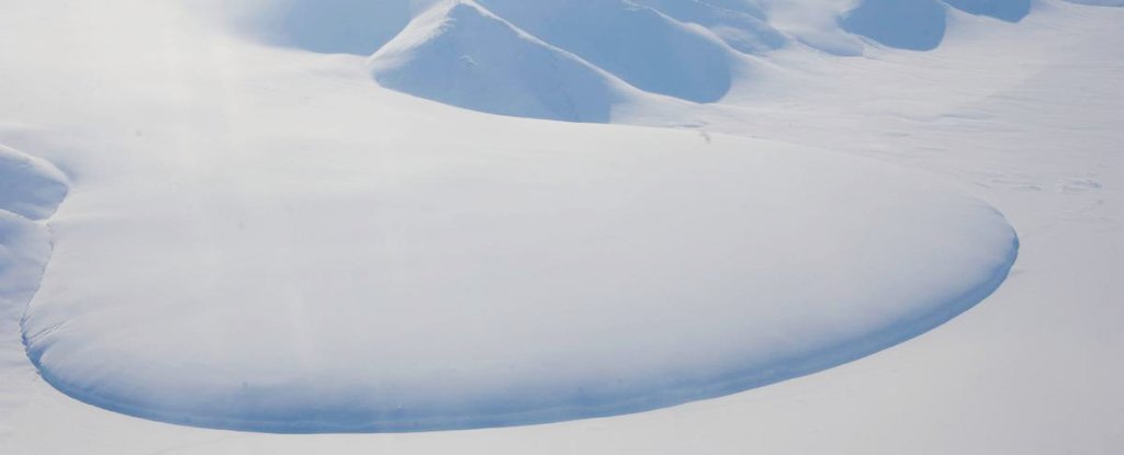
Piedmont Glacier in north-east Greenland (Coen Hofstede/Alfred Wegener Institute)
=============================================================
It should be simple. When temperatures on Earth get hotter, huge amounts of water ice trapped in giant glaciers begin to thaw, releasing water into the oceans, and causing sea levels to rise. It's the story of our lives.
By contrast, when global temperatures plummet, which happens during ice ages, sea levels proceed to drop, as water content retreats from the ocean, freezing once more in huge inland ice sheets.
This epic, ongoing cycle of ice ebb and flow – the transitions from glacials to interglacials – has been occurring since time immemorial. But there's a problem.
For years now, scientists tracking these cycles have suggested there's a "missing ice" problem: a mysterious discrepancy between very low sea levels roughly 20,000 years ago, and the volume of ice stored in glaciers at the same time.
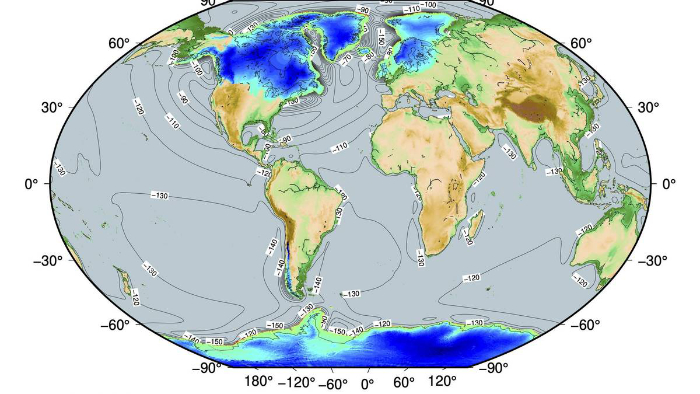
Ice surface elevation, 20,000 years ago. (Evan Gowan/Alfred Wegener Institute)
=============================================================
At its heart, the problem is this. During the peak of Earth's last ice age – the Last Glacial Maximum (LGM), which ended approximately 20,000 years ago – sea level is thought to have been about 130 metres (427 ft) lower than it is today, based on ancient coral sediment evidence.
But modelling suggests ice volume in glaciers at this point in time wasn't great enough to explain such a low sea level. So how can we explain this 'missing' ice?
In a new study led by geophysicist Evan Gowan from the Alfred Wegener Institute in Germany, researchers appear to have found a solution.
With a new reconstruction called PaleoMIST 1.0, the researchers were able to model the evolution of global ice sheets way into the past, much farther back than even the LGM.
"It looks like we've found a new way to reconstruct the past as far back as 80,000 years," Gowan says.
The results of the model suggest the anomaly in our data isn't a case of missing ice, but rather mistaken inferences about how low the sea level actually fell during the LGM.
According to PaleoMIST 1.0's ice physics model, the sea level dropped no more than 116 metres below where the waves lap today, with ice volume (being fully accounted for) clocking in somewhere around 42.2 × 10⁶ km3.
"We, therefore, find no basis for the missing ice problem, as our LGM reconstruction is compatible with existing sea-level constraints," the researchers explain in their study.
According to the team, the misdirection of the missing ice argument stems from a couple of factors – firstly, over-reliance on far-field indicators (coral sediment evidence from locations elsewhere in the world), which may not accurately represent global average sea levels as we once thought they did.
Another issue is a long-established but seemingly flawed method used to estimate glacier masses, oxygen isotope ratio cycles – which appears to produce discrepancies when reconciling sea-level height and glacier masses as far back as the LGM, at least.
"The isotope model has been used widely for years to determine the volume of ice in glaciers up to many millions of years before our time," says one of the team, geophysicist Paolo Stocchi from the Royal Netherlands Institute for Sea Research.
"Our work now raises doubts about the reliability of this method."
While the missing ice mystery appears to be solved, the researchers don't expect theirs will be the last word on this topic.
After all, their own solution's incompatibility with oxygen isotope ratio cycle-based reconstructions has, in a way, "created a new missing ice problem", the team admits.
Whether and how that new uncertainty can be resolved is a challenge for another day, in future research that may yield even clearer glimpses of ice sheet evolution in the distant past.
The findings are reported in Nature Communications.
They’re talking about glaciers on land; e.g., the glaciers that covered Canada and part of the U.S., and that covered a lot of the Eurasian land masses.
The melting of ice floating in water, as you point out, doesn’t change the level of the water.
Based on the seasonal rise and fall of temperatures on the continents that contain glaciers, they aren't going to melt any time soon. And if they did, it would be by some cataclysmic disaster that raised the global temperature above freezing for thousands of years to create the total melt down of glaciers.........
69% of this planet is oceans and 31% are land mass. Of that land mass, 30% is covered in deserts where there is no snow.
The North Pole is a floating ice cube so there would be no noticeable rise if it melted entirely.
The average annual temperature of the Antarctic is -47 degrees so it would require a millennium years long rise in temperature by 79 degrees to melt it sufficiently to raise the oceans. Any rise in earth's temperature by 79 degrees would fry every life form on this planet so that ain't gonna happen soon......
Have you read it?
He seems to claim that the earth was impacted by a mostly water object 2500km in diameter, Further he presents a NOAA map in the Madeira Abysmal Plain with unusually straight lines and claims it might be Atlantis.
I’m just reporting what I’ve read so far. It doesn’t seem to make sense but then I haven’t finished reading yet.
“sea level is thought “
“modelling suggests”
“Our work now raises doubts about the reliability of this method.”
“Whether and how that new uncertainty can be resolved is a challenge for another day,”
“Trust the Science!” Yeah, right!
Missing ice? Anyone living in a 4 season area like Minnesoda < see the ice melt away every spring.
Why is this a mystery to scientists?
FTA: But modelling suggests ice volume in glaciers at this point in time wasn’t great enough to explain such a low sea level. So how can we explain this ‘missing’ ice?
Answer: The model is wrong just like the global baloney model for temps.
You sure it doesn't decease the volume?
"Our work now raises doubts about the reliability of this method."It's SCIENCE!
Not all ice is in the ocean before it melts. If you melt an ice cube in a separate glass and pour it into your water, the water glass indeed gets more full.
During the ice ages, glaciers covered much of the land area of the Northern Hemisphere. Sea level indeed rose when these glaciers melted and the melt water flowed into the oceans. Today, ice covers land mainly in Greenland and Antarctica. Melting ice in the Arctic won’t raise sea level (the area around the North Pole is ocean), but melting ice in the Antarctic and Greenland certainly could.
You’re conflating glaciers, which form on land, and icebergs floating at sea. A floating iceberg melting won’t change the water level, but a glacier located on land, melting into the sea, will change the water level.
126 yards is quite a bit. There’s quite a lot of area of the earth that’s covered by ocean that’s less than 378 feet deep. Reduce sea level by that much and Great Britain no longer is an island, North America and Asia are no longer separated by the Bering Strait, Australia is connected to New Guinea and some of the islands in Indonesia, and probably some others.
Conversely, there’s also a good bit of low-lying coastal land with an elevation of less than 378 feet, all of which would become ocean if sea levels rose by that amount. Not positive, but we’d probably lose at least one state that’s increasingly red (Florida), but at the same time two blue states would likely be gone as well (Delaware and Rhode Island). Connecticut and New Jersey, I think, would survive, but they’d get a good bit smaller (there are some higher elevations in the northern part of both of those states). New Orleans would definitely be gone, but I’m not sure about the rest of Louisiana; it’d certainly be a good bit smaller. Elsewhere, the Netherlands and Denmark would be screwed. The U.K. would be reduced to mainly just Scotland, and most of the densest populated areas of China and a good chunk of Southeast Asia would be gone.
Sounds to me like ignoring physical evidence that doesn’t agree with a model.
Yes, you're right, when an iceberg melts the resulting volume of water is less than was the original iceberg, by the amount previously sticking up out of the water.
My bad.
Except for your “bull cookies” remark, we are in complete agreement.
When it warms, the glaciers melt, and the water runs off the land into the ocean. Then it gets colder, and the water becomes glaciers on the land again, exposing more oceans.
But do we really want to build cities on an exposed continental shelf?
That’s because it’s already in the water.
Ice that’s on LAND, think Greenland Ice Cap, Antarctic Continental Ice, would melt and raise the sea level. Ice in the North Polar Ice Cap is floating, so like your drink’s ice, would not overflow the oceans................
There’s an ebb and flow to life on this planet... and to the planet itself.
Only if the oceans were like a straight walled swimming pool..
Thanks Red Badger.
Disclaimer: Opinions posted on Free Republic are those of the individual posters and do not necessarily represent the opinion of Free Republic or its management. All materials posted herein are protected by copyright law and the exemption for fair use of copyrighted works.