Skip to comments.
Hurricane Katrina Live Thread, Part VIII
NOAA - NHC ^
| 29 August 2005
| NOAA - NHC
Posted on 08/29/2005 2:47:45 AM PDT by NautiNurse
Category 4 Hurricane Katrina is approaching landfall in Eastern Louisiana. At 4:00AM EDT the storm's center was about 90 miles south of New Orleans.
The following links are self-updating:
Public Advisory Currently published every 3 hours 5A, 8A, 11A, 2P, etc. ET
NHC Discussion Published every six hours 6A, 11A, 6P, 11P
Three Day Forecast Track
Five Day Forecast Track
Navy Storm Track
Katrina Track Forecast Archive Nice loop of each NHC forecast track for both three and five day
Forecast Models
Alternate Hurricane Models via Skeetobite
Bouy Data Louisiana/Mississippi
Buoy Data Florida
Lake Ponchartrain Real Time Water Level
Wind Speed Data
Images:
New Orleans/Baton Rouge Experimental Radar Subject to delays and outages - and well worth the wait
Mobile Long Range Radar Loop
New Orleans/Baton Rouge Radar
Ft. Polk, LA Long Range Radar Loop
Northwest Florida Long Range Radar
Storm Floater IR Loop
Storm Floater Still & Loop Options
Color Enhanced IR Loop
Other Resources:
Hurricane Wind Risk Very informative tables showing inland wind potential by hurricane strength and forward motion
Central Florida Hurricane Center
New Orleans Web Cams Loads of web cam sites here. The sites have been very slow due to high traffic
New Orleans Music Online Couldn't resist--love that jazz
Golden Triangle Weather Page Nice Beaumont weather site with lots of tracks and graphics
Hurricane City
Crown Weather Tropical Website Offers a variety of storm info, with some nice track graphics
Live streaming:
Cut and Paste:
http://www.wwltv.com/perl/common/video/wmPlayer.pl?title=beloint_khou&props=livenoad
Fully-linked version of the live feeds (just in case a few people don't want to first open up WMP to cut-and-paste) -
WWL-TV/DT New Orleans (WMP) - mms://beloint.wm.llnwd.net/beloint_wwltv
WVTM-TV/DT Birmingham (WMP) - mms://a1256.l1289835255.c12898.g.lm.akamaistream.net/D/
1256/12898/v0001/reflector:35255
WDSU-TV/DT New Orleans (WMP) - http://mfile.akamai.com/12912/live/reflector:38202.asx
Hurricane City (Real Player) - http://hurricanecity.com/live.ram
ABCNews Now (Real Player) - http://reallive.stream.aol.com/ramgen/redundant/abc/now_hi.rm
WKRG-TV/DT
Mobile (WMP) - mms://wmbcast.mgeneral.speedera.net/wmbcast
.mgeneral/wmbcast_mgeneral_aug262005_1435_95518 WDSU-TV/DT New Orleans via WESH-TV/DT Orlando - http://mfile.akamai.com/12912/live/reflector:38843.asx
Hurricane Katrina Live Thread, Part VII
Hurricane Katrina Live Thread, Part VI
Hurricane Katrina Live Thread, Part V
Hurricane Katrina, Live Thread, Part IV
Hurricane Katrina Live Thread, Part III
Katrina Live Thread, Part II
Hurricane Katrina Live Thread, Part I
Tropical Storm 12
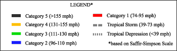
| Category |
Wind Speed |
Barometric Pressure |
Storm Surge |
Damage Potential |
Tropical
Depression |
< 39 mph
< 34 kts |
|
|
Minimal |
Tropical
Storm |
39 - 73 mph
34 - 63 kts |
|
|
Minimal |
Hurricane 1
(Weak) |
74 - 95 mph
64 - 82 kts |
28.94" or more
980.02 mb or more |
4.0' - 5.0'
1.2 m - 1.5 m |
Minimal damage to vegetation |
Hurricane 2
(Moderate) |
96 - 110 mph
83 - 95 kts |
28.50" - 28.93"
965.12 mb - 979.68 mb |
6.0' - 8.0'
1.8 m - 2.4 m |
Moderate damage to houses |
Hurricane 3
(Strong) |
111 - 130 mph
96 - 112 kts |
27.91" - 28.49"
945.14 mb - 964.78 mb |
9.0' - 12.0'
2.7 m - 3.7 m |
Extensive damage to small buildings |
Hurricane 4
(Very strong) |
131 - 155 mph
113 - 135 kts |
27.17" - 27.90"
920.08 mb - 944.80 mb |
13.0' - 18.0'
3.9 m - 5.5 m |
Extreme structural damage |
Hurricane 5
(Devastating) |
Greater than 155 mph
Greater than 135 kts |
Less than 27.17"
Less than 920.08 mb |
Greater than 18.0'
Greater than 5.5m |
Catastrophic building failures possible |
TOPICS: News/Current Events; US: Alabama; US: Florida; US: Louisiana; US: Mississippi
KEYWORDS: hurricane; hurricanekatrina; katrina; tropical; weather
Navigation: use the links below to view more comments.
first previous 1-20 ... 3,561-3,580, 3,581-3,600, 3,601-3,620 ... 4,241-4,248 next last
To: CindyDawg
"A lot of people were probably moved. Many in nursing homes are very ill these days. The aquity gets higher all the time. We need more information. It may have not been anything to do with the storm."
Three Nursing Home Residents Die During Hurricane Evacuation
BATON ROUGE, La. The hurricane evacuation has turned deadly in Louisiana.
Three people being bused to a Baton Rouge church died: one aboard the bus, another at the church and the third at a hospital. They were being moved from New Orleans.
The coroner's office in East Baton Rouge Parish isn't saying yet how the three people died but says many other people riding on the same bus were dehydrated.
He says some of the elderly people already were "pretty fragile."
Travelers reported the trip on the evacuation route from New Orleans to Baton Rouge was taking several hours because of traffic jams.
http://www.katc.com/Global/story.asp?S=3776385
3,581
posted on
08/29/2005 11:58:52 AM PDT
by
LibSnubber
(Lafayette, LA........PRAYER AGAINST STORMS on my homepage)
WWL: Area around Celebration Station is under water. (IIRC, that is Metarie, which is on the west side of the metro.)
To: All
As a result of its elevation near sea level, the Lake Pontchartrain Basin is quite vulnerable to tropical storms and hurricanes. Hurricanes are categorized by their windspeed in miles per hour (mph) (Table 4). Hurricanes have affected the Louisiana coastline with a frequency that peaks in September (Tables 5, 6). Hurricanes with significant monetary or human loss are memorialized by retiring their name (Table 8). The city of New Orleans averages 1.8 m (6 ft) below sea level, resembling a shallow depression surrounded by levees and water. The levee system in New Orleans is one of the most extensive in the world, but it is designed for a Category 3 hurricane maximum. Furthermore, storm vulnerability is made worse by ongoing wetland loss and barrier island erosion. The Basin is home to more than one million people and is extremely important to the vitality of the Gulf of Mexico ecosystem. For these and many other reasons, it is important to study past tropical storm events so that we can be better prepared for future events. The four storms in the figure below represent some of the most devastating, and therefore some of the most studied storms, in the Lake Pontchartrain Basin during the Twentieth Century.
 |
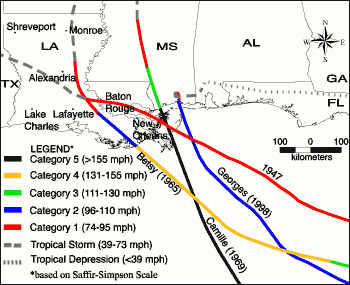 |
| Figure 25: Hurricanes 1947, Betsy, Camille and Georges |
| Hurricane of 1947 (September 04-21, 1947) |
| The 1947 Hurricane made landfall near the Chandeleur Islands, LA on September 19, 1947. Wind gusts of 112 mph and a central pressure of 967 millibars (mb) were measured at Moisant International Airport. A storm surge of 3.0 m (9.8 ft) reached Shell Beach, Lake Borgne. Moisant Airport fields were under 0.6 m (2 ft) of water while Jefferson Parish was flooded to depths of 1.0 m (3.28 ft). New Orleans suffered $100 million in damages. Total loss of life was 51 persons. As a result of this storm, hurricane protection levees were built along the south shore of Lake Pontchartrain to protect Orleans and Jefferson Parishes from future storm surges. |
| Hurricane Betsy (August 08-27, 1965) |
| Betsy was a fast moving storm (22 mph forward speed) that made landfall at Grand Isle, LA on September 10, 1965. The central pressure at landfall was 948 mb. Grand Isle experienced 160 mph gusts and a 4.8 m (15.7 ft) storm surge that flooded the entire island. Winds gusted to 125 mph in New Orleans with a 3.0 m (9.8 ft) storm surge that caused the worst flooding in decades. Winds reached 100 mph over most of southeast Louisiana and exceeded 60 mph as far inland as Monroe, LA. Offshore oil rigs, public utilities, and commercial boats all suffered severe damage. Loss of life from Betsy was a total of 81 persons, with 58 in the state of Louisiana. Damage in Southeast Louisiana totaled $1.4 billion. The Orleans Levee Board raised the existing levee to a height of 12 ft in response to the flooding caused by Betsy. |
| Hurricane Camille (August 14-22, 1969) |
| Camille intensified rapidly in the Gulf of Mexico, reaching Category 5 status by August 16. The small-diameter hurricane headed NE at 14 mph and made landfall in a sparsely populated section of the Mississippi coast on August 17. Wind estimates during landfall reached 175 mph. Atmospheric pressure at landfall was 901 millibars, second only to the Labor Day Hurricane of 1935 (892 millibars) as the most powerful storm ever to reach the U.S. coast. The storm surge generated by Camille flooded areas from lower Plaquemines Parish, LA to Perdido Pass, AL. The storm surge exceeded 24 ft in Pass Christian, MS. A 4.6 m (15 ft) storm surge inundated Boothville, LA. Storm surge reached 2.7 m (9 ft) in the Rigolets and 1.4 m (4.6 ft) in Mandeville, LA. The confirmed U.S death total was 258. Louisiana damages totalled $350 million. Structural damage at landfall was near complete. Louisiana damage was severe south of Empire, LA. |
| Hurricane Georges (September 15 - October 01, 1998) |
| Georges did extensive damage to Haiti, the Dominican Republic, Puerto Rico and other Caribbean islands. Georges made final U.S. landfall near Biloxi, MS on September 28. The maximum sustained surface wind at landfall was 104 mph and the minimum central pressure was 964 mb. Maximum storm surge in Louisiana was 2.7 m (8.9 ft) at Point à la Hache. Maximum surge along the U.S. Gulf Coast was 3.4 m (11 ft) in Pascagoula, MS. Georges severely eroded the Chandeleur Islands which are the first line of storm surge defense for southeast Louisiana and southern Mississippi. Total loss of life was 460 persons, all outside of Louisiana. Dozens of camps not protected by levees were destroyed along the south shore of Lake Pontchartrain. Georges again showed the vulnerability of New Orleans to hurricanes, and efforts resumed the following year to improve the levee system along the canals that connect the city with the Lake. |
Source: Hurricane dataset obtained from the National Hurricane Center website.
3,583
posted on
08/29/2005 11:59:25 AM PDT
by
cgk
(We'll have to deal w/ the networks. One way to do that is to drain the swamp they live in - Rumsfeld)
To: cgk
this is why TV news is so stupid. They sit there in the Walmart parking lot watching aluminum siding blow around instead of putting someone on the levies.
To: SlowBoat407
Anybody have any reports from Madisonville? It is apparent my wife's grandparents house in New Orleans in underwater, they are in Dallas hoping to find out about their house in Madisonville. My advice to them is get in the car and come stay with us in Seattle.
To: conservativewasp
they raised the entire island 13 feetHow do you raise an island? Does the former first floor of a house that survived the hurricane become it's basement?
To: wolfcreek
Could they move it to Northern Pennsylvania? We need some excitement up here.
3,587
posted on
08/29/2005 12:00:27 PM PDT
by
Palladin
(America! America! God shed His grace on Thee.)
To: cgk
Pass Christian for Camille?..looks like Katrina is a twin path almost mile for mile..unreal.
3,588
posted on
08/29/2005 12:00:35 PM PDT
by
WoodstockCat
(Gitmo? Let them eat Pork!)
To: Knitting A Conundrum
Wonder if Corky's BBQ made it...
To: MidwestOpinion
Hwy 90 went with Camille, too...it's right along the waterfront.
3,590
posted on
08/29/2005 12:00:44 PM PDT
by
Knitting A Conundrum
(Act Justly, Love Mercy, and Walk Humbly With God Micah 6:8)
To: Diddle E. Squat
FReeper Liberty2004 is in Metairie...
Continuing to send prayers.
3,591
posted on
08/29/2005 12:00:54 PM PDT
by
cgk
(We'll have to deal w/ the networks. One way to do that is to drain the swamp they live in - Rumsfeld)
To: Types_with_Fist
"New Orleans got hit hard but they DID NOT get the worst of it."
It should have. By just missing NO to the east it means the strongest winds would be directly from the north pushing waters from the lake directly into the city. It also means the storm surge would be worse than if the eye had approached NO from the south or west over land. The city should be flooded according to their worst predictions which were that the whole city would be under 30 feet of water.
To: Moose4
Concur, I think much remains to be discovered about the wider effects so far.
I think I'd be slow, also, to assume that we've seen everything so far. Lake Ponchartrain is still rising, presumably from runoff upstate, and I assume that the mississippi will rise as the upstate rain finds its way downhill as well.
3,593
posted on
08/29/2005 12:01:19 PM PDT
by
Ramius
(Blades for war fighters: http://freeper.the-hobbit-hole.net)
To: Marysecretary; NautiNurse
Anybody knows about a thread that might have been started to collect or direct on how to help victims. Other than the Red Cross?
3,594
posted on
08/29/2005 12:01:30 PM PDT
by
cll
To: Types_with_Fist; jpsb
[No they did not, when eye wall hits you or hits very very close, you did not dodge the bullet.] I don't want to argue with you. You're right, okay? New Orleans was wiped out by thge big one.
I believe the point is that the phrase "dodged the bullet" usually means that one has come out unscathed from a potentially life-threatening situation, but New Orleans has hardly been unscathed. While the "bullet" didn't kill the city, it is nonetheless badly wounded. The phrase "dodged the bullet" is not an appropriate one in the case where the bullet *did* hit the victim, even if it didn't kill the victim dead.
If the hurricane had swerved and missd the city entirely, *then* it would have "dodged the bullet".
The news folks really need to find a better, more fitting phrase to describe the situation.
To: Jack Black
Yep. They'll only report from there if they were trapped en route somewhere else.
3,596
posted on
08/29/2005 12:02:17 PM PDT
by
cgk
(We'll have to deal w/ the networks. One way to do that is to drain the swamp they live in - Rumsfeld)
To: BlueNgold; SittinYonder
I just wonder what possessed him to wear that pink shirt yesterday...That's exactly what my husband said yesterday!!
3,597
posted on
08/29/2005 12:02:19 PM PDT
by
eyespysomething
(What disgusts me the most is how other GStar families have had their wounds ripped back open! FU CS)
To: Jack Black
They sit there in the Walmart parking lot watching aluminum siding blow around instead of putting someone on the levies. Instead of putting "someone" on the levies, I'd think they have the technology to put unmanned video cams in more important areas than Walmart.
To: cgk; liberty2004
Good point. IIRC, in one of his posts a few days ago he said that he was on some of the highest land in the entire NO area, so hopefully he isn't affected.
To: SoothingDave
On the list of hurricane preparations is a first aide kit. You have your meds with you and take them if you leave or keep them close esp if life saving. You stock up on water and food. I have enough not just for mine but for a neighbor that might not have prepared too. That's the way you do it. No need to loot stores and RXs.
Navigation: use the links below to view more comments.
first previous 1-20 ... 3,561-3,580, 3,581-3,600, 3,601-3,620 ... 4,241-4,248 next last
Disclaimer:
Opinions posted on Free Republic are those of the individual
posters and do not necessarily represent the opinion of Free Republic or its
management. All materials posted herein are protected by copyright law and the
exemption for fair use of copyrighted works.
FreeRepublic.com is powered by software copyright 2000-2008 John Robinson