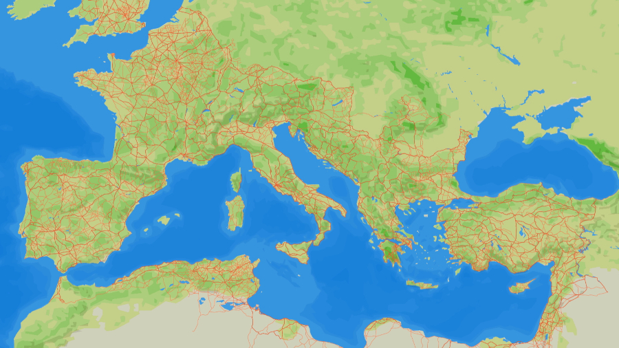
Map of Roman road network across Europe and North AfricaAutonomous University of Barcelona
Posted on 11/19/2025 6:06:35 AM PST by SunkenCiv
ZME Science reports that a team of researchers led by Pau de Soto of the Autonomous University of Barcelona has created a high-resolution digital map of the entire known network of Roman roads called Itiner-e. These routes, as they were circa A.D. 150, cover some 186,000 miles. The study will help archaeologists calculate more accurate travel times across the Roman world, which would have had an effect on trade and warfare. De Soto and his colleagues began by extracting data from historic copies of Roman maps and the more than 8,000 known miliaria, or Roman milestones. Then they examined more recent historic maps, aerial photographs, and modern satellite imagery for glimpses of the ancient roads. Where physical evidence of roads had not survived, the researchers connected known milestones or any other archaeological evidence linked to roads by following the most plausible path along the topography. In all, less than three percent of the Roman roads in the study are well known and have been thoroughly mapped. Almost 90 percent of them fall into the category of "conjectured networks," based upon the location of settlements, milestones, and other archaeological evidence. The final category consists of "hypothetical roads" presumed to have linked ancient cities, but no physical evidence for them has been found to date. Read the original scholarly article about this research in Scientific Data. To read about the discovery of a submerged section of a Roman road in the Venetian lagoon, go to "A Trip to Venice."
(Excerpt) Read more at archaeology.org ...
Map of Roman road network across Europe and North AfricaAutonomous University of Barcelona
Hey!!
Look where all the roads lead to!!
Fascinating! More extensive than I ever imagined.
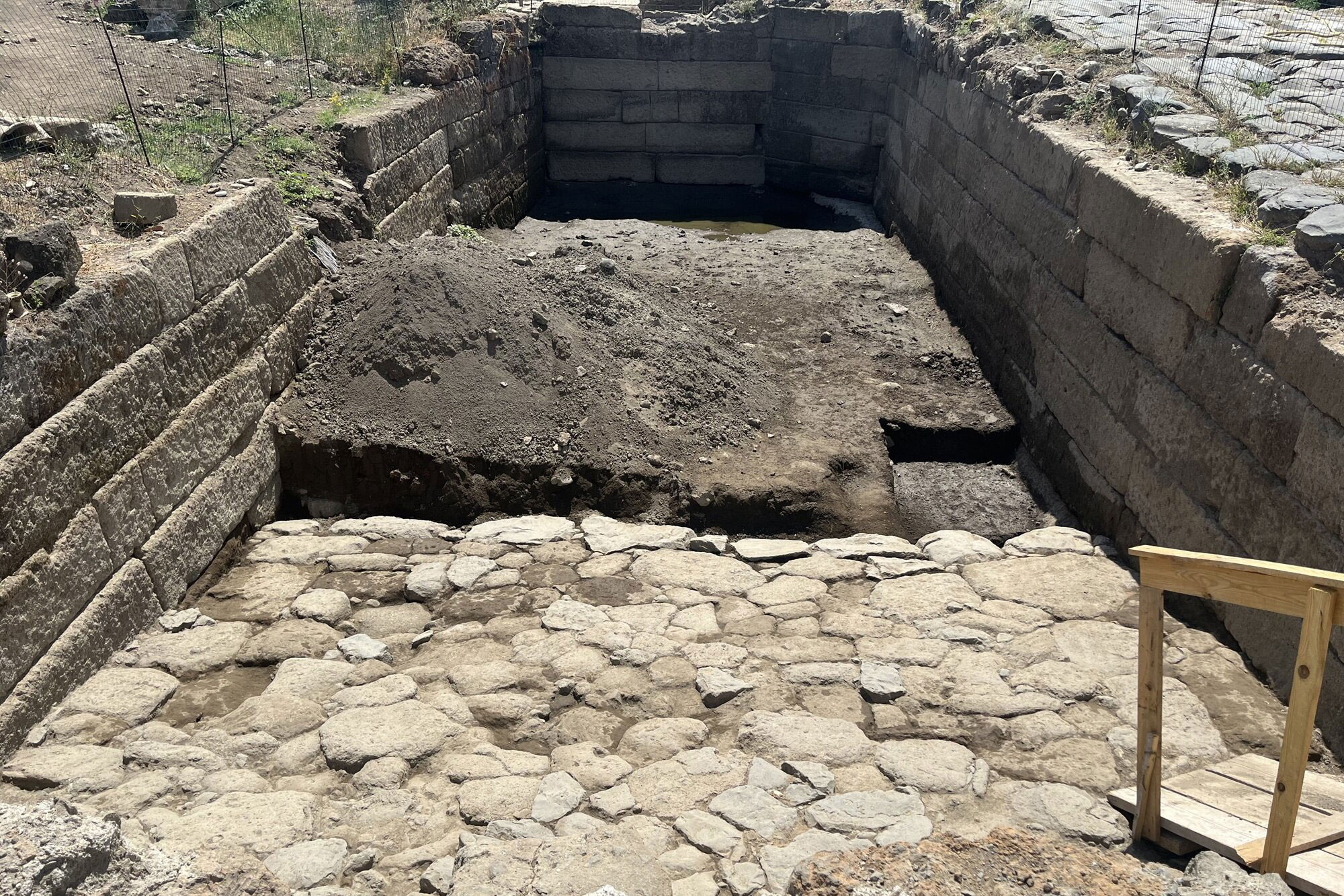
According to a statement released by the University of Missouri, a massive stone-lined basin for holding water has been found in the ancient city of Gabii by a team of archaeologists led by Marcello Mogetta. Gabii was a powerful early rival of the city of Rome, which was located just 11 miles away. The basin had been carved into bedrock around 250 B.C., although parts of it may be older. "This discovery gives us a rare look at how the early Romans experimented with city planning," Mogetta said. "Its location -- at the center of the city near the main crossroads -- suggests it may have been a monumental pool that was part of the city's forum," he added. A terraced complex carved into the slope of a volcanic crater has also been uncovered in Gabii. Mogetta explained that these structures in civil spaces were inspired by Greek architecture to reflect image and power as well as function. Thermal imaging scans of the area around the basin indicate that traces of a temple or another kind of large, civic building may remain. "If it's a temple, it could help us explain some of the artifacts we've already found in the abandonment levels of the basin, such as intact vessels, lamps, perfume containers, and cups inscribed with unusual markings," Mogetta said. The pool was ritually closed around A.D. 50, he concluded. To read more about Gabii, go to "Roman Buildings Grow Up."Large Pool Discovered in Early Roman City | Archaeology Magazine | October 20, 2025
Marcello Mogetta
the full size version at the article:
https://archaeology.org/wp-content/uploads/2025/11/News-20251111-Roman-Road-Network-Map.jpg
😄👍
Rome if you want to
Rome around the world
Do they all lead to Rome?...............
No Autobahns, though..............

Funkytown!
There were also (as there are now) vicinal roads, which were not up to Roman military standards. Some existed earlier and continued in use, some developed over time as local shortcuts or routes to places which had started to thrive.
On the campus where I once spent the tail end of growing up, footpaths worn by shortest-route-seekers would often be given the sidewalk treatment, if not, a barrier would be erected over the summers and the path reseeded.
Where are the CCTVs located? 🤔😊👍. Pretty sure some of the cobblestones are still walked on today.
Built to the specs of the 2 horse cart. And the basis of all roads, and therefore all things we put on roads, to this day. Yup, the 2 horse cart is the most impactful invention in human history.
What surprises me is North Africa. Never knew they put that much work into that area.
Roman roads are such good evidence of what civilization lost when the empires of antiquity collapsed into the “Dark Ages”. Look at all the care and thought that went into making this road network. Then for probably 1300 years afterward, roads were simply made by horses and carts going over the same path and beating down the vegetation. From layers of stone with drainage back to mud paths.
It was greener at the time, leading to Greek and Phoenician colonies, then Roman conquest.
Herodotus reports that the ancient Lake Tritonis was still lingering on west of Egypt in the form of small lakes connected by marshes.
The Phoenicians explored at least as far south from Gibraltar as Mount Cameroon, which was in eruption (it’s the only active volcano from recorded human times in west Africa), and of course circumnavigated Africa, clockwise, for the Pharaoh.
Archaeologically the Phoenicians are known as far south as what used to be Mogador, which apparently got its name from Mago, a onetime Phoenician/Carthaginian ruler whose name was on the pottery excavated there.
In what’s now Morocco the Phoenicians, then the Carthaginians, and eventually the Romans, took over Lixus. I’m not sure how old it was, or what its origin was. The web consensus is that the Phoenicians founded it. I wouldn’t be surprised to learn that it has a deeper history, although it could be adjacent to the classical ruins. It was abandoned in the 14th c when its port got silted up and the current town arose nearby. The Greek “apples of the Sun” were said to come from there, and it’s speculated that those were actually tangerines.
https://freerepublic.com/tag/romanafrica/index
https://search.brave.com/videos?q=how%20far%20romans%20africa
https://adamvaneckotraveller.sk/morocco/the-archaeological-site-of-lixus-near-the-city-of-larache/
Cool stuff... Thank you! I knew they were there but look at that road system. They were not there on vacation for sure... :)
Visiting the local courthouse and they had a map of the county showing items of interest when the county was organized. On the map was a military road from Sioux city military post to Sioux falls military post. Was within a mile of where I grew up.
so cool! thanks for sharing, i’ve explored many of these roads and sites throughout Switzerland and central Europe.
https://itiner-e.org/
Disclaimer: Opinions posted on Free Republic are those of the individual posters and do not necessarily represent the opinion of Free Republic or its management. All materials posted herein are protected by copyright law and the exemption for fair use of copyrighted works.