Duly noted, ER333 - I will not post again. Sorry.
Home·
Settings·
Breaking ·
FrontPage ·
Extended ·
Editorial ·
Activism ·
News
Prayer PrayerRequest SCOTUS ProLife BangList Aliens HomosexualAgenda GlobalWarming Corruption Taxes Congress Fraud MediaBias GovtAbuse Tyranny Obama Biden Elections POLLS Debates TRUMP TalkRadio FreeperBookClub HTMLSandbox FReeperEd FReepathon CopyrightList Copyright/DMCA Notice Donate
Monthly Donors · Dollar-a-Day Donors · 300 Club Donors
or by or by mail to: Free Republic, LLC - PO Box 9771 - Fresno, CA 93794
| Free Republic 3rd Qtr 2024 Fundraising Target: $81,000 | Receipts & Pledges to-date: $38,626 | |||
| ||||
| Woo hoo!! And we're now over 47%!! Thank you all very much!! God bless. | ||||
Posts by PavewayIV
-
Emergency: California’s Oroville Dam Spillway Near Failure, Evacuations Ordered
-
EXCLUSIVE-U.S. warship stayed on deadly collision course despite warning-container ship captain
Everyone is saying not to speculate - to wait for the investigation to find out the 'facts' on the Fitzgerald collision. The audio of the Porter collision should be proof enough for everyone here that we will probably never hear any detail from the Navy regarding this incident except in the most general sense.The captain of the Porter was relieved of command three weeks after the 2012 collision, but details of the sequence of events leading up to it were never released to the public AFIK. A year after the fact, they released the bridge audio, but only in response to a FOIA request. People were able to piece together what happened from that. The Fitzgerald accident is probably a lot more complex.
Anyone that thinks there will be a quick investigation or ANY disclosure of what happened by the US Navy is dreaming. They will delay and hide everything possible from the public. This seems pretty routine with them in other accidents. I don't doubt they will act internally to discuss the details to prevent this from happening again, but I doubt we'll ever see any uncomfortable details from the Navy.
A FOIA request might produce a few scraps of information a year from now, but I could see them refusing any requests since the accident resulted in the deaths of sailors.
I'm not begrudging the US Navy their secrecy, but I have to shake my head in disbelief when people on social media insist that everyone simply wait for the 'results of the official investigation' that will never be made public. Maybe we'll hear something from the Japanese Coast Guard, but I won't keep my hopes up for that, either.
-
[SNIP] USS Fitzgerald Crew Fought Flooding For An Hour Before Distress Call Reached Help
All good points, Norseman. And yes, I had the headings screwed up again as you noted. Just to toss more junk into the mix, we also have no idea if there were other Navy ships in the area along with the Fitzgerald. I'm imagining a busy bridge tracking several ships and somehow getting fixated on one (Wan Hai) or confused, not an inattentive crew blissfully unaware of their surroundings.I was just re-reading a Naval Institute article and great comments: Fitzgerald: When A Big Ocean Gets Small that gives a good idea (to someone like me) what goes into Navy crews keeping ships from plowing into each other all the time. For their part, merchant mariners insist a ship like the ACX Crystal does not traverse busy shipping lanes 'on autopilot' with an empty bridge. The ACX Crystal is described as a 'medium-sized' container ship. There are certainly much larger commercial vessels that it would have to be concerned about in those waters, so I kind of doubt the 'autopilot' theory unless the Crystal crew was suicidal.
I've been trying to follow the more recent FreeRepublic thread here: EXCLUSIVE-U.S. warship stayed on deadly collision course despite warning-container ship captain - many good comments by everyone. A nice education so far for me from some knowledgeable people on how these 'ship' things work.
I wish we knew more from either the US Navy or Asian Container Express, but I'm guessing neither one will want to say anything in public for a long, long time. I have very low expectations that either will be forthcoming with all the details unless they can't avoid doing so. More likely than not, we'll get the watered-down MSM 'public' version that will leave many questions unanswered. Frustrating, considering the lives lost.
-
[SNIP] USS Fitzgerald Crew Fought Flooding For An Hour Before Distress Call Reached Help
Here’s the traffic in the vicinity around the time of the collision from VesselFinder. It could be the Wan Hai was much closer to the Fitz than what I’m interpreting from the comments above.
-
[SNIP] USS Fitzgerald Crew Fought Flooding For An Hour Before Distress Call Reached Help
"Does it seem reasonable that the Crystal would be hit so hard that it turned 90 degrees..." My extremely limited understanding of a ship like this is that it would be difficult to turn that fast in that short of time. On the other hand, I look at those pictures of the Crystal's bow and can't imagine the Fitzgerald escaping the teeth (flukes) on that massive anchor.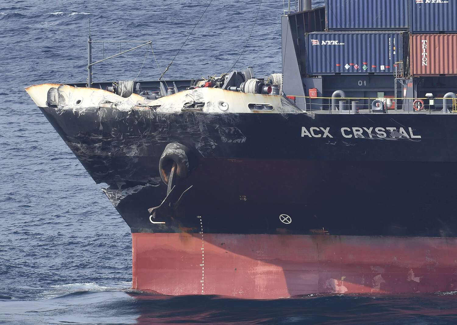
Commenters on other boards have noted how the gash in the Crystal's bow looks like it was made by the anchor chain being dragged across it at tension. It kind of makes sense that the anchor grabbed the Fitzgerald at one point and was pulled out. The chain cut across the Crystal's bow as the Fitzgerald continued on, eventually dragging the Crystal's bow to the right. Probably dragged the Fitzgerald around a bit before ripping away. No idea if that's even possible - I'll leave that to mariners for comment.
The only reason I bring up the 'anchor snagging' situation above is in the one (unlikely) case where nobody was on the Crystal's bridge, the collision occurred and pushed/dragged the Crystal's bow 90° before the ships untangled. The auto-heading would have presumably steered the Crystal back on it's previous heading (with an anchor in tow). That would explain the AIS course changes. The crew would have made it to the Crystal's bridge afterwards and tried to figure out what happened, maybe not seeing the damaged bow immediately.
Mariners say the above is unlikely because a commercial ship's bridge is never unmanned in a busy shipping lane and there are various collision warning alarms that would have sounded if someone was 'asleep'. There's also emergency stops that kick in if a collision is detected. So there's no way, according to merchant mariners, the Crystal would just run on 'autopilot', ram another ship and resume course like nothing had happened. That sounds reasonable to me.
That still leaves the peculiar track of the Crystal unexplained. If it was under manual control and the ship did turn at the last minute but was unable to avoid the Fitzgerald, then they would have stopped immediately after the collision. I can't imagine any scenario where they would have resumed course/speed for nearly a half an hour before deciding to turn back - no matter what was going on on the Crystal itself.
So as unlikely as the first scenario is ('autopilot' ramming Fitz then resuming course/speed), that one - at face value - seems to explain the AIS track. Once again though, I can't possibly claim to know anything about what these crews would do in this situation - there was probably much more going on that we don't know yet. Neither explanation makes much sense, so I'm inclined to think both are wrong (or incomplete as we understand them so far).
"...And if they had to know they collided, why no distress call for an hour?..."
This may have been one of those 'lost in translation' things. If you read the articles carefully, the Japanese Coast Guard says they were not notified until 2:20. It doesn't even say if the Crystal's crew notified them. One of the earlier reports said the Crystal notified their shipping company first for direction, and then the shipping company itself eventually notified the Japanese CG after verifying with the USN. Too many inconsistent reports for now - I think we'll have to wait to find out how the 'reporting' chain actually happened.
The media makes it sound like the greatest crime of all here was that the Crystal didn't report the collision the minute it happened. FWIW, an aircraft pilot's priorities in an emergency are to aviate (keep the plane flying), navigate and THEN communicate - in that order. You don't grab the mic and start blabbing away to someone the second your engine falls off. That's not the immediate priority. I can't imagine a mariner would act any differently. In the event of a collision, they are worried about other things far more important than 'notifying the Coast Guard' who are too far away to be of much help anyway. I wouldn't read too much into the 'one hour delay' until we have a better picture of what happened.
-
[SNIP] USS Fitzgerald Crew Fought Flooding For An Hour Before Distress Call Reached Help
"...You seem to have a good idea on the location of the three ships..."All from the accounts others have posted. I'm better with things that fly.
"...What do you think are the chances that the watch on the Fitzgerald saw the second tanker, Wan Hai, and was moving to avoid that while remaining unaware of the Crystal and that he was cutting across in front of it?"
Based on the position of the ships described above, I would think the Fitzgerald was well ahead, to right of the Wan Hai and moving faster, i.e., if Fitz was 40° ahead and to the left of the Crystal, then it would have been ahead and to the right of the Wan Hai.
When the Wan Hai turned from 70° to 60°, it would have been behind and moving away further left from the Fitzgerald's line of travel. The Fitzgerald (from the description above) sounds like it remained on a 70° heading.
"...While I have a hard time believing the crew on the Fitzgerald was so incompetent that they could have missed a supertanker if that were all there was to it, is it possible that they were completely distracted by the other ship? That starts to at least make some sense..."
This was supposedly a busy shipping lane at what is reported to be the busiest time of the day: early AM ships steaming to scheduled morning berthing times in Tokyo ports and afternoon/evening ships leaving Tokyo ports steaming southwest. The Fitzgerald would have nearly constantly had some targets on its radar moving somewhere in a 20nm or 30nm radius around it. Between computerized course conflict warnings, humans watching the radar blips and other humans eyeballing the horizon, I kind of doubt they were just/merely/only distracted by the Wan Hai.
My useless opinion is that they would have been about as likely to miss the Crystal or be distracted by another ship about as much an air traffic controller would be to miss an aircraft or be distracted by other aircraft on their radar screen. Possible? I suppose, but highly unlikely. This is what they do their entire shift and it's damn important. I have to believe the answer is a bit more complicated than that in ways I don't fully understand - that is, in terms of whatever else goes on on a Navy destroyer's busy bridge.
-
[SNIP] USS Fitzgerald Crew Fought Flooding For An Hour Before Distress Call Reached Help
Aaand... I completely messed up the headings. The ships would have been heading 070° initially and turned to 060° to stay in the shipping lane.
-
[SNIP] USS Fitzgerald Crew Fought Flooding For An Hour Before Distress Call Reached Help
The Reuters article is... well, Reuters. They have a bad habit of 'alternate facts' when it suits them, especially in matters related to U.S. foreign policy or the military, IMHO."...according to a copy of Captain Ronald Advincula's report to Japanese ship owner Dainichi Investment Corporation that was seen by Reuters."
Curious in itself. I can't imagine how much Dainichi would want to keep the information private considering the litigation that is sure to follow, not to mention the possibility of criminal charges against either ship's captains. So somewhere between Capt. Advincula's completed report and Dainichi, Reuters managed to get a peek. OK... let's go with that.
The English Reuters article gives a garbled picture of what happened. Translation issues? Editing? No idea, but I found a better account from a poster estarzinger post #421 on CruiserForum (here):
Perhaps a one-step better translation . . . .* "This is my English translation of the same report by Reuters in Japan in Japanese.
ACX Crystal captain wrote to the company that while cruising to Tokyo bay at 18 knots, TWO watch crews of ACX found the destroyer on 40 degree port side 3NM in distance around 1:15AM. 5 minutes later the destroyer suddenly started moving and continued on their collision course. While manually steering, ACX gave caution to the navy ship by turning on/off the light without any reaction. then decided to take hard starboard turn for collision avoidance but both ships crashed around 1:30AM.* Takeshi from Yokohama"
Probably still not perfectly accurate representation of details from the actual captain's report
Then from Presbyterian Reporter@76:
“Note WAN HAI 266 was to the port side of USS Fitzgerald. Sailing parallel to ACX Crystal with USS Fitzgerald sandwiched. When ACX Crystal A/C to 070 then minutes later WAN HAI also A/C to 070. It seems that USS Fitzgerald does NOT change course and stays on track.....”
So one scenario that might make some sense (given the above as best we know) goes something like this:
1:15 local - Crystal, Wan Hai and Fitzgerald all traveling along Tokyo inbound shipping lane heading 60°. Wan Hai off Crystal's port side, Fitzgerald 'between' but ahead of both ships (40° to port of Crystal). No potential conflicts as all ships are moving same direction.
1:17 local - Crystal, then Wan Hai both adjust heading to 70° to follow established shipping lane. Fitzgerald does not, so it begins converging with the Crystal, but is still 3nm away at this point.
1:20 local - (10 min before collision) the Crystal notices the Fitzgerald getting closer, either visually, via radar or both. Nothing to panic about, but they start plotting (or use their ARPA) to see if there will be an actual conflict given both ship's speed and heading. The Fitzgerald would be doing the same given the Crystal's new heading. (I think the 'suddenly started moving' wording regarding the Fitzgerald's movement is just a translation error - maybe 'began converging')
>1:20 local - Crystal determines the two ships will eventually come too close (in approx. 10 min) so calls Fitzgerald to coordinate - standard operating procedure, even though the Crystal is stand-on starboard ship. They either were not able to contact the Fitzgerald or did and something was miss-communicated. The Crystal did not feel the need to change speed or course yet for whatever reason.
<1:29 local Crystal eventually resorts to flashing light to catch Fitzgerald's attention, which apparently failed as well. Should have used collision horn as well, but no mention of that. At that point, Crystal's captain figures Fitzgerald doesn't see them or still isn't changing course, so orders hard starboard turn at the last minute to avoid collision.
1:30 local - collision.
note: 1 knot = 1 nautical mile per hour. The Crystal was traveling at 18 knots, or 3nm every 10 min. If the Fitzgerald was 3nm at 40° 10 minutes before hand and moving faster than the Crystal, then they could certainly have crossed paths at 1:30. I'll leave the maffs to someone else.
Nothing is 'proven' by the above, but at least we have some agreement between AIS, Wan Hai report (from Presbyterian Reporter) and a translation of a bit more detailed Japanese version of the Reuters article. It's a likely scenario given what little information we have, and would put the Crystal turning at the last minute, not 10 minutes out. That (in my mind) makes a lot more sense. We'll find out what was happening on the Fitzgerald in about six months from the US Navy (if they leave anything in their report un-redacted).
Of course, this whole scenario relies too heavily on a confidential internal company report from the captain that Reuters somehow managed to see, so there's that.
-
Emergency: California’s Oroville Dam Spillway Near Failure, Evacuations Ordered
Thanks for the interesting link on the old local mines, Ray76. Why, if I can still lift a pickaxe when I retire at 80...
-
Emergency: California’s Oroville Dam Spillway Near Failure, Evacuations Ordered
"...With the complexity of the metavolcanic rock geology of the spillway hillsides, they may have deep seams that could facilitate subterranean flow..."No doubt. But the old-timer prospectors looked for gold by panning the river to figure out what hillside stream/ravine/gully might be the source. Those erosion features were mostly worn into fractured or softer rock seams on the hillside. Those erosion-revealed seams would have been the exact place they would have started digging promising-looking ore and would have been (at the time) far above the Feather River bed. And if they were hand-digging, they would have followed the fractured/weathered rock seams deeper into the hillside looking for rich ore.
Now I have no idea if there were any kinds of mines like that there. My point is simply that 'fractured rock seams' are the exact spots where they would have started digging. *If* there were any holes in that hillside, that's where they would have been. The 'sinkhole' area is low because it's at the top of a historic erosion gully/weathered rock seam before the dam was built. It always struck me as odd that the original dam engineers didn't level that off more with fill.
Regardless, undiscovered (at the time of build) underground weathered rock seams themselves on either side of a dam abutment are troubling, although DWR seems pretty casual about all the 'natural springs' they seem to find. Proper grouting should take care of them.
"...It may be that the "grout curtain" is not sealing very well or that their are fissures deeper below the grout curtain..."
I wasn't aware that they had built a grout curtain near the emergency spillway weir. The old dam diagrams showed the expected grout curtain under the dam itself and there were some textual references to grouting around the gatehouse Not that it wouldn't have been a good idea to build one under the weir - I just missed any mention of it in the documentation. Is it a vertical curtain directly under it?
-
Emergency: California’s Oroville Dam Spillway Near Failure, Evacuations Ordered
I wonder if there were any old gold mines in that hill before they built the dam? Remember that peculiar, out-of-place 'bump' under the edge of the spillway when they were shot-creteing it? Maybe that was an old drift they found and plugged up before anyone could photograph/video it.On the other side of the hill (upstream side of e-spillway) would have been another likely spot for some old-timer to gopher away looking for the mother lode. They may not even have known about those mines when they built the dam. But then again, remember how they just stopped building the second intakes for some reason? Maybe the whole hill is perforated with small hand-dug, long-abandoned mines?
I know it's a bit tin-foil-hat, but if there were hydraulic communication from somewhere upstream of the e-spillway to under the main spillway, then there's your 'piping' and unexplained drainage.
I suppose you could just grout in any tunnels you knew about, but there may have been old ones they didn't because of collapsed or filled openings, etc. Makes me wonder about the weird "not a sinknole" depression on the e-spillway side, too. They were busy coring/grouting something on the upstream side of the e-spillway early on.
-
Emergency: California’s Oroville Dam Spillway Near Failure, Evacuations Ordered
"...keeping it is only asking for future trouble. IMHO..."There are plenty of engineers on the internet that seem to share your view. This will eventually be a billion-dollar project (Folsom spillway/gates was $900M). Nobody expects this to be anywhere near the $400M (and certainly not the fantastical $250M) pricetag dangled in front of the public so far. How much money are they actually saving by skipping the baffle sill relative to the total real cost of this project?
If nothing else, patching up a broken piece of the 'old' spillway will serve as a very visible monument to the DWR's strange sense of economy. "We're too cheap to do the whole job. Just enough is good enough!"
Is it absolutely necessary to replace it now? Does it pose any risk? Is it important relative to everything else? I don't know, but NOBODY is going to complain if they just do it now when they have everything there. When you force 180K people evacuate their homes, then optics become rather important. 'Patching' seems like something you want to avoid if nothing else but for appearances sake.
If they were more transparent and gave the engineering community enough information to understand their reasoning, then maybe they would agree it's unnecessary or inadvisable right now. Nobody needs to convince me of anything, but I'm worried when I see people in the industry skeptical of DWR's actions over and over again. There's plenty of reasonable speculation as to why they're doing one thing or another, but never any confirmation either way - nobody really knows and DWR isn't saying.
DWR simply cannot play the "Just Trust Us" card to a skeptical public and/or engineering community, yet they repeatedly (and quite smugly) toss that one out over and over again. I can only shake my head and wonder what the hell they are really thinking most of the time.
-
Emergency: California’s Oroville Dam Spillway Near Failure, Evacuations Ordered
"...Well, to be fair, the baffle sill section of the spillway has probably seen the least amount of water of the entire structure..."I don't disagree, but delaminating and scouring a concrete monolith like that down to the rebar is... troubling. This part of the spillway has probably seen the most amount of concrete missile damage. And a half meter or so of cavitation damage - enough to tear rebar out of the deck right at the sill - also seems to warrant more than a patch. Maybe they're worried about the time it would take for such massive blocks of structural concrete to strengthen before Nov. 1st if they rebuilt. I really don't know.
"...But seriously, is it something they intend to replace next year?..."
As far as I understand Croyle's statements, no. They intend to patch it up as part of the lower spillway rebuild this year. That's it. They never mentioned anything about deferring demolition and replacement until next year - I don't think that's their intention. Maybe I missed something.
-
Emergency: California’s Oroville Dam Spillway Near Failure, Evacuations Ordered
I can't locate the specific article(s) that quote him meyer, but I recall Croyle saying on several occasions that the existing baffle sill section (w/diffuser blocks) was to remain in place. The surface damage on the concrete baffles will be repaired. you can see the demolition of the lower spillway has proceeded right up to the sill section.Of course, nobody in the press or audience thought to ask him why, exactly, they were preserving that particular piece of beat-up, half-century old design. We all know the answer though: because it hasn't failed yet. DWR's acid test for public safety and responsible engineering is: "Has it failed yet? No? Then it's safe and nobody can prove otherwise."
I've read criticism from engineers that this isn't a terribly good design. Fire-hosing water at 100 fps down a steep spillway and then using energy-diffusers at the bottom is kind of third-world-ish and far from 'modern practice'. In fact, it's a recipe for disaster in the future.
In addition (but apparently more questionable/controversial) is the diffuser/stilling pool emptying at right angles to the diversion pool. The problem is water backing up into the dam outlets as we saw this winter. Some of the energy from the spillway could be used to increase flow out of the upstream diversion pool and potentially flush silt or erosion debris further downstream. Some argue this shouldn't ever be necessary, and others say the potential for scouring and erosion outweigh the potential benefits. Seems like a useful idea to me since the emergency spillway is going to remain mostly unarmored. Disclaimer: I haven't designed any dams since fifth grade.
Nobody (that I've read/found) has a good technical reason for why DWR is insisting on the historic engineering approach besides old-fashioned cheapness. It's 'good enough'. Comparisons have been made with the new Folsom spillway were effort has gone into slowing the flow as much as possible. They use a stepped spillway design there for that purpose. The design is inherently safer because you're not introducing a massive amount of energy into the flow, dealing with that hydrodynamic hell for a thousand feet or so and then having to dissipate it at the sill.
Slowing the flow means higher side walls. Oroville has 20' training walls (new Folsom has 30' ones). Croyle has always been oddly insistent about the training walls being adequate even though nobody has ever really pressed him on this issue. That always seemed strange to me - why call that out if nobody is even questioning it? That (to me) says there is some reason DWR is trying avoid even the suggestion that they might need higher walls. A more modern stepped spillway would require them, AFIK.
Higher training walls need significant anchorage beyond simply being bonded to the chute floor. DWR is either unwilling to pay for that and/or cannot physically provide that because of the fractured rock underlying the walls. One engineer was describing something similar to the secant pilings they need to use for the e-spillway cutoff wall. 3000' of pilings on both the spillway would be pretty expensive, so the existing firehose/mass/dissipator scheme with 20' training walls was dusted off, with more mass and anchorage added in.
Plus, seam cavitation ensures eternal work for local concrete contractors because every dam person seems to know they NEVER work anywhere on earth. It's always temporary and cosmetic. And besides, what's the worst that can possibly happen - seam erosion, seal failure, underslab erosion and hydrodynamic pumping? Why, that's preposterous! That's never happened anywhere EVER. Damn conspiracy theorists!

-
Emergency: California’s Oroville Dam Spillway Near Failure, Evacuations Ordered
The trouble with DWR hiding everything at Oroville Dam behind self-imposed or bogus CEII secrecy is that they can't even point out when they do something good/right for a change. It appears they may have installed new piezos or flow gauges on the weir drains. I believe seepage was measured previously by manual inspection of drain flow/catchment at a single point - not sure.Bill Husa of the ChicoER took this great Google 360 image from the top of the gate house on June 1st (h/t Dan Reidel on Twitter).
If you pan over to the downstream side of the e-spillway weir, you can see a series of three little pads, each with a ground-level square white cover with some metal tubes protruding - the tallest of which looks like a gooseneck vent.
Screen caps from the image:

A closer view below with a nearby railroad tie included for scale. A common U.S. railroad tie is 8' (2.4m) long.

I don't have any specific information on what these are - piezos/flow gauges is just a guess. For all I know, they might be vent holes to DWR's secret underground lair. But that would be CEII, so you didn't hear that from me.
Plans are to add a pretty substantial RCC apron on the downstream side of the weir, so these would eventually be under several feet of concrete. They would have to build some kind of access to them or just remount higher on the surface of the new apron.
On old blueprints, the weir was shown to have a rectangular open box drain at grade that runs along the center of it's length, with T's every 40' or so emptying to the downstream side of the weir at the very bottom. They were not visible because the bottom edge of the monoliths were a few feet below the ground surface.
There appeared to be some kind of piping related to these drains washed out after the spill, but you couldn't make out much on how many there were or how they were accessed. The one blurry photograph that gave any clue suggested that at least one under-weir drain was piped to a small, square concrete basin, maybe 4'x4' and a foot deep, topped with a manhole cover. That manhole cover was never visible in any old photographs, so this may just have been something like a buried junction box for more than one drain.
I don't know if the new little access points are actually related to the under-weir drains or if they're piezometers to measure underground seepage independent of the drains. Either would make sense.
No wonder this is CEII - in either case noted above, these are obvious attack vectors for terrorists. How many times have we read about jihadis going after under-weir drains? Why, if I had a nickel for every time I read about these kind of tragic attacks...
-
Emergency: California’s Oroville Dam Spillway Near Failure, Evacuations Ordered
As far as DWR statement, I imagine that was just cautious wording from a PR (not a engineering) standpoint just in case. They have access to all the best models and forecasts. By 20 May, they would have known the releases/snowmelt/remaining snow cover put them in pretty good shape, but why stick their neck out and actually say "...No more releases..."? A sufficiently powerful Pineapple Express two weeks later (now) would leave them with egg on their face - again.DWR made that statement on the 20th, but started ripping things up in a serious way last week. A release after that point would have been problematic - erosion, debris in river, etc. Not catastrophic, but bad. Still, their actions last week tell me they were sufficiently confident of the low risk that they proceeded despite their earlier statement. If they ended up being wrong today, they would have reminded us that they did anticipate one more release. Expectations management, I guess.
Regional differences and weather patterns are enough to explain why the Oroville Reservoir basin melted off before the rest of the Sierra this year. They might get blasted next winter while the south remains dry. I've only been watching the weather there closely this year, but there is nothing like a consistent pattern across the entire Sierra. It's patchy and precipitation is often in narrow swaths. Tahoe and the eastern ranges generally get a lot more snow than the northern or southern ranges.
The 30+ inches of snow-water equivalent mostly applied to the Sierra mountain tops in the Oroville Watershed. Most of the catchment area had far less than that and it melted off weeks ago. They had a lot of snow this year, but nothing like the Tahoe snowpack below.
Those little blue areas on the snowmelt forecast (mountain tops/north faces) still do have several feet of snow and probably over 30" of snow water equivalent, but just in a few square km area. I'm sure there's still a risk of localized flooding from heavy melt runoff under those peaks, but nothing that translates to much of an effect overall on the Feather River forks.
I'm not familiar with the summer weather patterns there to speak to the possibility of torrential rains or another Pineapple Express in the Oroville watershed, but I don't think summer rain has been much of a problem there - at least not to the extent that it would force another release from the dam.
Hydro plant releases should be enough for this summer. I expect them to work well into December as well - the Nov. 1 'deadline' is another managing expectations thing. It would be extraordinary if they ever had to spill in November.
-
Emergency: California’s Oroville Dam Spillway Near Failure, Evacuations Ordered
Some Sierra snow pack is still substantial, but there's just not much left in the Oroville Reservoir catchment area. I'm not sure warm rains would cause much snow melt contribution any much to the reservoir inflow. It would be far worse in other Sierra watersheds further south.Below is yesterday's 24-hour snow melt. Brighter Blue = 1.4" to 2" water equivalent from melt, green line is the Oroville Dam watershed boundary.
1"+ would normally have been a rather heavy melt day a copule of months ago with 70%+ snow cover across the whole watershed, but snow cover is only something like 3% today.

For comparison, here's what it looked like in March. This was for 72 hours, but you can see the snow cover was far greater.

-
Emergency: California’s Oroville Dam Spillway Near Failure, Evacuations Ordered
Given DWR's er... budget O&M and tendency to put PR over engineering, I if DWR could have 'solved' the green spot in times past by hosing down the area with RoundUp or other glyphosate-based nerve/weed agent.The green areas appear rather uniform in historic imagery and at some point (2009?) it takes on an odd, mottled appearance.
This reminds me of the appearance of railroad embankments in my neck of the woods. Being too steep to mow but very visible to the public in places, they would 'mow the weeds with a hose' in the 80's and 90's. When the sides of the embankments would grow back, they would take on the same kind of toxic waste dump mottled look from herbicide residue and stayed that way for a decade. These herbicides are suppose to be a one-time deal, i.e., they are generally not designed to be persistent.
Yeah, I'm sure they are not suppose to do that and, of course, the green areas serve as a sentinel marker of seepage. But who needs seepage detection anyway? Seepage means the FERC boys will get all riled up and who needs that kind of attention? It's just from a natural spring anyway - hose it down with RoundUp and make the problem disappear.
-
Emergency: California’s Oroville Dam Spillway Near Failure, Evacuations Ordered
And in case anyone is wondering about the legitimacy of the reports DWR published, one can clearly see that the inspector, WPennington, signed off on the 2004 report on 2/2/02, so there! -
Emergency: California’s Oroville Dam Spillway Near Failure, Evacuations Ordered
Was browsing through DWR's latest Inspection Report dump If you're a terrorist, please do not read!Haven't checked all of them regarding green spot, but saw this interesting blurb about instrumentation in the Jan. 20, 2004 report:

On the Nov. 18, 2002 report, the 1999 Dam Review Safety Board is said to have made the recommendation. The inconsistency is irrelevant but interesting nonetheless
Now, not only were only 51 of 56 Oroville Dam piezometers noted to not be working 13 years ago, but it was the actual Dam Safety Review Board that specifically recommended that they should be retired (and eventually were). This simply defies all logic, and I'm just some idiot on the internet watching this from a thousand miles away.
Is there any rational ENGINEERING reason for such a recommendation given the history of dam failures they might have prevented if used? It's like an airline's 'Safety Board' recommending a few panels of gauges be pulled out of a modern passenger aircraft because some are broken and the information can be gathered indirectly through other means (like 'high-speed disassembly at altitude' or 'contact with terrain').
Browse by Forum
Get Connected! Join Free Republic Today!
Already a Member? Log into your Free Republic account.
Breaking News (News/Activism)
- RFK Jr. expected to drop out of race by end of week, plans to endorse Trump: Sources
- Dear FRiends, We need your help to keep Free Republic funded. Thank you very much for your continuing support. [FReepathon]
- Nonfarm payroll growth revised down by 818,000, Labor Department says
- Unrealized Gain Tax—A Coming Sea Change in FY2025 Budget Proposal(Wealth Tax)
- LIVE:President Donald J. Trump and Vice Presidential Nominee, Senator JD Vance to Deliver Remarks on National Security in Asheboro, North Carolina 8/21/2024 2PM EDT
- California lawmakers urge Newsom to put electric vehicle fleet mandate on hold after I-80 truck fire
- Biden secretly orders US to prepare for nuclear threats from China, Russia and North Korea
- Byron Donalds urges House GOP leaders to hold vote on Biden impeachment after bombshell report
- Double Trump/Vance Events Day! Vice Presidential Nominee, Senator JD Vance to Hold Presser on Crime and Safety, Kenosha, Wisconsin LIVE, 12pC, President Donald J. Trump Delivers Remarks on Crime and Safety in Howell, Michigan LIVE 3pE
- Arizona law requiring proof of citizenship to vote supported by 24 state AGs in emergency stay with SCOTUS
- More ...
Front Page News (News/Activism)
- Commerce Secretary: ‘Not Familiar With’ Jobs Numbers Being Revised Downward by Over 800K
- Multi-Millionaire Michele Obama: 'Be Suspicious of Those Who Take More Than They Need'
- Whoa: Unemployment Has Been ‘Revised’ and the Numbers Are Not Good
- Nicole Shanahan says RFK Jr. campaign considering joining forces with Trump
- Tim Walz praised communism as system where 'everyone is the same and everyone shares'—Kamala Harris calls for 'equality of outcomes' where 'we all end up in the same place'
- Buttigieg on if Harris Will Back Israel Arms Embargo to Win Votes: She Backs Peace, ‘Focused on Outreach’ to Protesters
- Dem Sen. Murphy: Harris Will ‘Have More Details’ Around Economic Plan ‘When She Wins’
- Hezbollah commander lured out of hiding with phone call moments before deadly airstrike: report
- Preliminary Report Finds Thomas Matthew Crooks Was 'Fragged,' Rifle Likely Disabled After SWAT Operator's Incredible Shot
- Supreme Court Blocks Biden’s Title IX Rules That Allowed Men In Women’s Sports
- More ...