
Posted on 09/12/2008 11:29:13 PM PDT by NautiNurse
The eyewall of Hurricane Ike crossed Galveston Island in the early hours of Saturday morning. Reports indicate as many as 20,000 residents of Galveston Island chose not to evacuate as storm surge engulfed the island. The Freeport Chief of Police reported as many as 2000 residents did not evacuate as flood waters swamped coastal communities. There are widespread reports of power outages and coastal flooding throughout the Texas/Louisiana region. The U.S. Coast Guard received hundreds of calls Friday afternoon to rescue people stranded by flood waters along the barrier islands and Galveston Bay communities.
Multiple fires broke out in the Greater Houston area fueled by strong winds. Fire fighting efforts were hampered by flood waters. Brennan's Restaurant, a landmark in Houston, burned to the ground. A 584-foot freighter crippled in the Gulf of Mexico and its crew of 22 survived the storm after The U.S. Coast Guard was forced to abort rescue efforts Friday afternoon due to foul weather
Gulf Coast wholesale gasoline prices jumped to nearly $5 a gallon over fears that water and wind damage could keep the facilities closed for days or longer. Oil companies had shut down 97.5 percent of production in the Gulf of Mexico by Friday morning and were battening down refineries and petrochemical plants in an area that accounts for one-fifth of U.S. refining capacity.
Exxon Mobil reported evacuating workers from its Gulf Coast offshore platforms and onshore facilities in the anticipated path of Ike, shutting down daily production of about 36,000 barrels of oil and 270 million cubic feet of gas..
Public Advisory Updated every 3 hours
Discussion Updated every 6 hours
Buoy data: Western Gulf of Mexico
Houston/Galveston Long Range Radar
Corpus Christi Long Range Radar
Brownsville Long Range Radar
Lake Charles Long Range Radar
|
||||||||||||||||||||||||||||||||||||||||||||||||||||||||
Additional Resources:
Navy Tropical Cyclone
Storm Pulse Very cool site
KHOU Houston
ABC 13 News Houston
FOX News Houston
KPLC Lake Charles
KFDM 6 Beaumont/Port Arthur
KKBMT 12 Beaumont
KRIS-TV Corpus Christi
KZTV Corpus Christi
Brazoria County Emergency Management
Galveston County Emergency Management
Chambers Country Emergency Management
Liberty County Emergency Management
| Category | Wind Speed | Barometric Pressure | Storm Surge | Damage Potential |
|---|---|---|---|---|
| Tropical Depression |
< 39 mph < 34 kts |
Minimal | ||
| Tropical Storm |
39 - 73 mph 34 - 63 kts |
Minimal | ||
| Hurricane 1 (Weak) |
74 - 95 mph 64 - 82 kts |
28.94" or more 980.02 mb or more |
4.0' - 5.0' 1.2 m - 1.5 m |
Minimal damage to vegetation |
| Hurricane 2 (Moderate) |
96 - 110 mph 83 - 95 kts |
28.50" - 28.93" 965.12 mb - 979.68 mb |
6.0' - 8.0' 1.8 m - 2.4 m |
Moderate damage to houses |
| Hurricane 3 (Strong) |
111 - 130 mph 96 - 112 kts |
27.91" - 28.49" 945.14 mb - 964.78 mb |
9.0' - 12.0' 2.7 m - 3.7 m |
Extensive damage to small buildings |
| Hurricane 4 (Very strong) |
131 - 155 mph 113 - 135 kts |
27.17" - 27.90" 920.08 mb - 944.80 mb |
13.0' - 18.0' 3.9 m - 5.5 m |
Extreme structural damage |
| Hurricane 5 (Devastating) |
Greater than 155 mph Greater than 135 kts |
Less than 27.17" Less than 920.08 mb |
Greater than 18.0' Greater than 5.5m |
Catastrophic building failures possible |
|
|
Previous Threads:
Hurricane Ike Live Thread III
Hurricane Ike Live Thread II
Hurricane Ike Live Thread I
TS Hanna, Hurricane Ike & TS Josephine [Other than that, the tropics are calm]
Tropical Storms Hanna, Ike and Josephine, TD Gustav (Other than that, the tropics are calm)
I don’t know if have this info or not...
Bolivar Peninsula stretches lazily along the Gulf of Mexico for 27 miles. At it’s widest point between Crystal Beach and Caplen it’s 3.5 miles wide, and at it’s narrowest point in the Rollover Pass area it’s 1/4 mile wide. Although classified as a peninsula, it’s actually a barrier Island, and is accessible by land from a bridge over rollover pass to the mainland through southern Chambers County.
Bolivar’s five residential communities include: Crystal Beach, Port Bolivar, Caplen, Gilchrist and High Island. The population more than doubles during the summer months as owners of beach homes and tourists arrive to enjoy the beach, sun, bay sunsets, fishing, relaxation and the many attractions of the Bolivar Peninsula “Island”.
In 2000 the population of people living on the Peninsula was nearly 4,000.
Picture of Crystal Beach on Bolivar Peninsula Before and After
http://graphics8.nytimes.com/images/2008/09/15/us/16ike_5a.jpg
Y’all don’t think that maybe jpsb decided at 8 to evacuate, and hasn’t been heard from since because he was packing up, on the road and he’s now somewhere with no computer or no power?
I kind of thought that if he’d decided not to evacuate, he’d have checked back in later that day & said so...
But it would be nice to know for sure.
TONS OF OVERLAY PICTURES HERE OF BOLIVAR PENINSULA
some are animated gif’s
some are before and after’s pictures
This is the best site I have found for before and after photos.
Hurricane Ike Live Thread Part II
Friday, September 12, 2008 4:28:10 AM · 971 of 993
jpsb to TornadoAlley3
Thanks, will make the stay/go call around 8am.
Post Reply | Private Reply | To 963 | View Replies
Hurricane Ike Live Thread Part II
Thursday, September 11, 2008 8:53:03 PM · 874 of 993
jpsb to NautiNurse
This storm is no stronger Alicia in 83, San Leon will be OK. Just about everyone here is staying. My neighbor has a concrete/stone three story house. I will be fine I am on the high side of San Leon (12’), I worry about the folks staying on the low side (4’)of San Leon.
~~~
IMO : He hunkered down,,,
No power/etc. ...
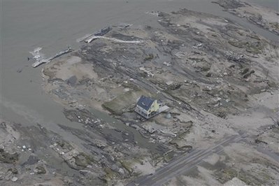
here is the backside of the last standing house - you can see the Rollover Pass canal (gulf side of the canal) in the right hand corner of the picture (the gulf side is on the left corner of the picture - the house front faces towards the west to Galveston Island)
http://www.jakeabby.com/cb/gilchrist2.jpg
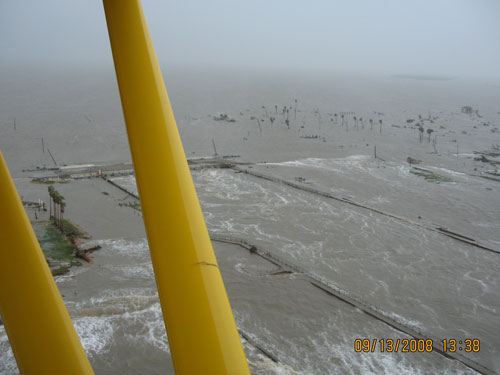
Here is a very early picture of the Rollover Pass Bridge before the water went down (the bridge is barely noticable but it is behind the 2 yellow poles on the plane) you are looking out towards the gulf in this picture. The last house standing would be to the left and is just out view in this picture. You can see the canal wall tops just barely in the photo also. There was at least one group of people that actually walked through here trying to make it to higher ground during the thick of it. They ended up at High Island which is to the left and few miles away.
http://www.jakeabby.com/cb/398.jpg
Glad you are OK. Sorry to hear about your town. —FRegards
“... debris to ride on till they get to the mainland.”
It should be noted that swimmers on the other side of a hurricane will be going in the opposite direction, out to sea.
That would not be fun.
I just met him on the hurricane thread, but I think he evac’ed. No doubt he has no power at his house (if he still has a house!).
Was just checking out videos of the damage, and noticed this vid, shot from a helicopter travelling along the Seawall.
http://www.click2houston.com/video/17480828/index.html?rss=hou&psp=news
The Seawall is looking good, if a little nibbled on at one end. Looks like it did its job astoundingly well, too - almost everything that was *behind* the century old Seawall is more or less intact, if a bit waterlogged. Impressive.
Anyone who was behind it and stayed through the storm owes their lives to a group of long-dead engineers who built better than I think even they knew. We don’t build that way any more, more’s the pity.
I'm not clear about what this statement implies.
This guy thinks the media blackout is to protect AIG
http://www.khou.com/forums/viewtopic.php?t=28823
Just a quick post on a borrowed wifi lap top, I’m fine, San Leon hit very hard. Will post details once power restored. See ya later.
Thanks for taking the time to let us know how you are doing. A whole bunch of us were very worried about you!
jpsb has checked in. He is safe.
:)Thank God.Your ears were ringing.(((Hugs)))
Thanks for that terrific news NN!!
Are all our Gulf Coast freepers now accounted for?
Awesome - glad to be proved wrong!
Oh boy is that great to read. These Texans are a tough bunch. Now waiting to hear about friends on Oak Island. If by chance anyone comes across info please let me know.
Disclaimer: Opinions posted on Free Republic are those of the individual posters and do not necessarily represent the opinion of Free Republic or its management. All materials posted herein are protected by copyright law and the exemption for fair use of copyrighted works.