Posted on 07/25/2004 12:36:29 AM PDT by Yosemitest
|
Ship-sinking monster waves revealed by ESA satellites
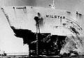
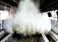
Once dismissed as a nautical myth, freakish ocean waves that rise as tall as ten-storey apartment blocks have been accepted as a leading cause of large ship sinkings. Results from ESA's ERS satellites helped establish the widespread existence of these 'rogue' waves and are now being used to study their origins. Severe weather has sunk more than 200 supertankers and container ships exceeding 200 metres in length during the last two decades. Rogue waves are believed to be the major cause in many such cases. Mariners who survived similar encounters have had remarkable stories to tell. In February 1995 the cruiser liner Queen Elizabeth II met a 29-metre high rogue wave during a hurricane in the North Atlantic that Captain Ronald Warwick described as "a great wall of water… it looked as if we were going into the White Cliffs of Dover." And within the week between February and March 2001 two hardened tourist cruisers – the Bremen and the Caledonian Star – had their bridge windows smashed by 30-metre rogue waves in the South Atlantic, the former ship left drifting without navigation or propulsion for a period of two hours.
"The same phenomenon could have sunk many less lucky vessels: two large ships sink every week on average, but the cause is never studied to the same detail as an air crash. It simply gets put down to 'bad weather'." Offshore platforms have also been struck: on 1 January 1995 the Draupner oil rig in the North Sea was hit by a wave whose height was measured by an onboard laser device at 26 metres, with the highest waves around it reaching 12 metres.
The fact that rogue waves actually take place relatively frequently had major safety and economic implications, since current ships and offshore platforms are built to withstand maximum wave heights of only 15 metres. In December 2000 the European Union initiated a scientific project called MaxWave to confirm the widespread occurrence of rogue waves, model how they occur and consider their implications for ship and offshore structure design criteria. And as part of MaxWave, data from ESA's ERS radar satellites were first used to carry out a global rogue wave census.
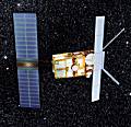
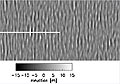
ESA's twin spacecraft ERS-1 and 2 – launched in July 1991 and April 1995 respectively – both have a Synthetic Aperture Radar (SAR) as their main instrument. The SAR works in several different modes; while over the ocean it works in wave mode, acquiring 10 by 5 km 'imagettes' of the sea surface every 200 km.
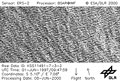
"The raw imagettes are not made available, but with their resolution of ten metres we believed they contained a wealth of useful information by themselves," said Rosenthal. "Ocean wave spectra provide mean sea state data but imagettes depict the individual wave heights including the extremes we were interested in. "ESA provided us with three weeks' worth of data – around 30,000 separate imagettes – selected around the time that the Bremen and Caledonian Star were struck. The images were processed and automatically searched for extreme waves at the German Aerospace Centre (DLR)."
"Having proved they existed, in higher numbers than anyone expected, the next step is to analyse if they can be forecasted," Rosenthal added. "MaxWave formally concluded at the end of last year although two lines of work are carrying on from it – one is to improve ship design by learning how ships are sunk, and the other is to examine more satellite data with a view to analysing if forecasting is possible." A new research project called WaveAtlas will use two years worth of ERS imagettes to create a worldwide atlas of rogue wave events and carry out statistical analyses. The Principal Investigator is Susanne Lehner, Associate Professor in the Division of Applied Marine Physics at the University of Miami, who also worked on MaxWave while at DLR, with Rosental a co-investigator on the project.
"Looking through the imagettes ends up feeling like flying, because you can follow the sea state along the track of the satellite," Lehner said. "Other features like ice floes, oil slicks and ships are also visible on them, and so there's interest in using them for additional fields of study. "Only radar satellites can provide the truly global data sampling needed for statistical analysis of the oceans, because they can see through clouds and darkness, unlike their optical counterparts. In stormy weather, radar images are thus the only relevant information available." So far some patterns have already been found. Rogue waves are often associated with sites where ordinary waves encounter ocean currents and eddies. The strength of the current concentrates the wave energy, forming larger waves – Lehner compares it to an optical lens, concentrating energy in a small area.
However the data show rogue waves also occur well away from currents, often occurring in the vicinity of weather fronts and lows. Sustained winds from long-lived storms exceeding 12 hours may enlarge waves moving at an optimum speed in sync with the wind – too quickly and they'd move ahead of the storm and dissipate, too slowly and they would fall behind. "We know some of the reasons for the rogue waves, but we do not know them all," Rosenthal concluded. The WaveAtlas project is scheduled to continue until the first quarter of 2005. Related news ERS-2 has new role 'nowcasting' Europe's weather ESA's orbiting hurricane hunter back in action
In depth
Related links
|
I think this will answer some questions about "unexplained disappearances of ships" and I hope other freepers also find this "very interesting".
| Posted by Rebelbase On News/Activism 07/23/2004 3:25:25 AM CDT with 16 comments yahoo news ^ | 7/21/04 | unknown PARIS (AFP) - European satellites have given confirmation to terrified mariners who describe seeing freak waves as tall as 10-storey buildings, the European Space Agency (ESA) said. "Rogue waves" have been the anecdotal cause behind scores of sinkings of vessels as large as container ships and supertankers over the past two decades. But evidence to support this has been sketchy, and many marine scientists have clung to statistical models that say monstrous deviations from the normal sea state only occur once every thousand years. Testing this promise, ESA tasked two of its Earth-scanning satellites, ERS-1 and ERS-2, to monitor the... |
||||||
| Ship-sinking monster waves revealed by ESA satellites |
||||||
| Posted by uglybiker On News/Activism 07/23/2004 12:25:27 AM CDT with 42 comments European Space Agency ^ | 7/21/04 Rare photo of a rogue wave Ship-sinking monster waves revealed by ESA satellites 21 July 2004Once dismissed as a nautical myth, freakish ocean waves that rise as tall as ten-storey apartment blocks have been accepted as a leading cause of large ship sinkings. Results from ESA's ERS satellites helped establish the widespread existence of these 'rogue' waves and are now being used to study their origins. Severe weather has sunk more than 200 supertankers and container ships exceeding 200 metres in length during the last two decades. Rogue waves are believed to be the major cause in many such... |
||||||
You know, but you aren't telling until the grant money runs out. It's GLOBAL WARMING!! Art Bell told me so.
First it was hugh, then came series, and now we must add monstor to the Freeper lexicon.
Nessie? That you?
Lanai Tsunami DepositThis is the deposit left by a giant tsunami as it washed up the south coast of Lana'i. The deposit consists of beach boulders plus coral fragments and sand, and extends to about 100 meters above sea level. Here it is about 4 meters thick.
by Volcano WorldThe Hilina Slump a.k.a. "The Big Crack"A 4,760 cubic mile chunk of the Big Island (Hawaii) is breaking away at the rate of 4 inches per year. This is the Hilina Slump, and it is said to be "the most rapidly moving tract of ground on Earth for its size." The Hilina Slump can move much faster. At 4:48 AM, November 29, 1975, a 37-mile-wide section suddenly dropped 11* feet and slid seaward 26 feet. The result was a magnitude-7.2 quake and a 48-foot-high tsunami. This was a minor of the slump. If the entire 4,760-cubic-mile block decided to break off, it would probably create a magnitude-9 quake and a tsunami 1,000-feet high. All the coast-hugging cities of the Hawaiian Islands would be swept away. And LOOK OUT Australia, Japan, and California.
by Wiliam CorlissJapan faces tidal wave threatScientists in Japan have discovered a fault in the seabed off the country's coast with the potential to unleash a giant "tsunami" tidal wave. The newly-detected fault lies off the south-eastern coast of Japan and may have been responsible for the magnitude 8.1 earthquake which struck the country in 1944, they say... The fault is close enough to the Japanese coast for there to be only minutes between a substantial earthquake along it and the tsunami reaching land... Jin-Oh Park and his colleagues believe that the fault they have found may have been responsible not just for a magnitude 8.1 quake in 1944, but a nearby magnitude 8.3 quake two years later.Giant Tsunami Would Follow Predicted Canary Isles EruptionThe computer model, compiled in collaboration with Steven Ward of the University of California, Santa Cruz, predicts that the tsunami will have a height of 100 metres (330ft) from crest to trough when it crashes into the shores of nearby north-west Africa. By the time it reached its final destination, the east coast of Florida and the Caribbean islands, the tsunami would still be up to 50 metres high.The drowning waveAny day now, a gargantuan wave could sweep westwards across the Atlantic towards the coast of North America. A mighty wall of water 50 metres high would hit the Caribbean islands, Florida and the rest of the eastern seaboard, surging up to 20 kilometres inland and engulfing everything in its path. If you thought the tsunamis that periodically terrorise the Pacific Ocean were big, consider this: the Atlantic wave will be five times bigger. It will start its journey 6000 kilometres away, when half an island crashes into the sea.
by Tristan MarshallLandslideEveryone realised that dropping something the size of New York City into the ocean would kick up a big wave, but it was only when Moore returned to Hawaii to explore the island of Lanai that he realised just how big. On the south side of the island, limestone boulders were scattered, some as much as 100 metres above sea level. Since the island itself is made of volcanic rock, the limestone could only have come from coral reefs beneath the sea surface. Moore also found fields of coral and seashells as high as 120 metres. The piece of mountain that is shifting is much larger than the slide that soaked Lanai. It's more on the scale of the "Nuuanu" collapse that spun the New York-sized chunk of rock off Oahu more than 1 million years ago, says Julia Morgan, a geologist at the University of Hawaii's Manoa campus on Oahu, who has been watching the mountain closely.
by Jonathan Knight
7 August 1999Could sea slides occur off N.J. coast?A computer simulation of the continental shelf 100 miles off the coast of New Jersey suggests that there may be pockets of water trapped under great pressure deep beneath the ocean floor. The study concluded that if such pressurized deposits of water exist, they could pose a threat of sudden undersea landslides. Peter B. Flemings and Brandon Dugan of Pennsylvania State University said even a small shaking of a mild earthquake could be enough for a sudden release of the water. That could cause undersea landslides down the side of the continental shelf. Such slides, involving many tons of sediment falling like an undersea avalanche down the side of a submerged mountain, have been known to cause tsunami waves.Mt Pinatubo's brimming lake threatens thousandsThis year has been particularly wet, and since the rainy season began in June the water level has been rising by up to a metre each week. The last time Rodolfo and Alonso flew over the lake in a military helicopter, they estimated that the water was only four metres from the lowest point of the crater wall, a V-shaped cleft called the Maraunot notch. Rodolfo and Alonso estimate that if the notch eroded down 10 metres, 30 million cubic metres of water would spill out. The water would probably mix with loose volcanic sediment on the way, hugely increasing its volume and creating a cement-like mixture knows as a "lahar". Rodolfo has seen fast-flowing lahars in action before. "It is a horrendous sight - horrifying and exceedingly beautiful." Engineering solutions to the threat include reinforcing the notch, or boring a tunnel into the crater to drain the lake. But the government says it is too late for such action now the rainy season has started. Rodolfo and Alonso believe this complacency could be disastrous and are now working with Oxfam to reach local agencies and people directly.
by Joanna Marchant
25 July 01Asteroids and TsunamisTsunami can travel at around 400 mph in deep water. When they reach shallow water they slow down, and that's when the real danger begins. The front of the wave slows first and the effect is like a pile-up on a freeway, with the rear of the wave catching up to the front. The wave increases in height from this bunching effect. The final height of the wave depends on several factors, but the shape of the sea floor has the greatest impact.
by Michael Paine
5 November 1999Out ThereIn the spring of 1986, I published my explanation of the black spots in a scientific journal: The Earth's atmosphere was being bombarded by house-sized, water-bearing objects traveling at 25,000 mph, one every three seconds or so. That's 20 a minute, 1,200 an hour, 28,800 a day, 864,000 a month and more than 10 million a year. These objects, which I call "small comets," disintegrate high above the Earth and deposit huge clouds of water vapor into the upper atmosphere. Over the history of this planet, the small comets may have dumped enough water to fill the oceans and may have even provided the organic ingredients necessary for life on Earth.
by Louis A. Frank
and Patrick Huyghe
Scientists reacted to my announcement as if I had plowed through the sacred field of established science with a bulldozer. I had. If the small comets were real, one scientist commented, textbooks in a dozen sciences would have to be rewritten... I spent more than a year answering the objections of critics. But I didn't convince them. It was 10,000 to 1 -- actually 2, myself and John Sigwarth, whose task as my graduate student assistant had been to help me resolve this black-spot mystery. "We have taken a representative poll of current opinion in this field," an editor at Nature wrote in rejecting a small-comet paper we submitted to them in 1988, "and the verdict goes against you." It was my first encounter with taking polls as a way of doing science.
Note that the pictures on the MaxWave site are of the parties not of the waves. European science at its best.
Whoa....never heard THAT statistic before. Two ships a week??
Gives me pause about taking my next cruise LOL.
The waves are monstors of seriesly hugh proportions!
Wow!
I bet the crew isn't thinking very interstering but W.T.F.
Bump!
So, you're saying the aliens are causing these waves to happen. Make sense. ;->
There's some confusion about measuring waves. Scientists measure wave height like circuit geeks measure signal amplitude - peak minus no wave level. Reporters, surfers, and normal people look and a wave and think of the height as being from the top to the bottom -- makes sense but that can turn a '29-metre' wave into a '58-metre' wave.
It would have been good of them to clarify what they meant.
I got one:
Remonstrate: to convert someone into a monster twice.
--Boris
Disclaimer: Opinions posted on Free Republic are those of the individual posters and do not necessarily represent the opinion of Free Republic or its management. All materials posted herein are protected by copyright law and the exemption for fair use of copyrighted works.