Free Republic
Browse · Search
News/Activism
Topics · Post Article

Skip to comments.

Hurricane Isaac
NHC/NOAA ^ | 27 August 2012 | NHC/NOAA

Posted on 08/28/2012 9:24:55 AM PDT by NautiNurse

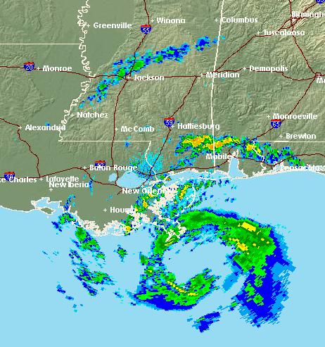
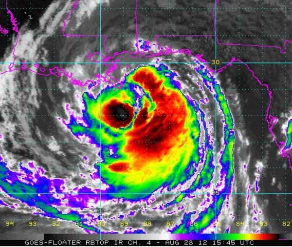
Isaac has been slow to organize and attain hurricane status. Slow moving minimal Hurricane Isaac threatens to dump up to 20" of rain in portions of its path. Storm surge of 6-12ft is expected.

Media news readers have gleefully reported RNC scheduling adjustments to accommodate public safety during Tampa storm warnings.

A water spout formed in the Tampa Channelside area at 4:43PM Monday afternoon, a short distance from the RNC Convention Center. The Florida Atlantic coast was inundated with torrential rain squalls from far-reaching Isaac outer bands. Several tornados were reported in the Florida peninsula.

The weather took its toll on protester turnout at the GOP convention. Cara Jennings, a community organizer from Palm Beach County, braved the elements dressed as a sparkling pink vagina, along with several dozen other protesters.

GOP governors of Gulf Coast states announced they would remain at their posts, rather than attend the Tampa convention. British Petroleum reported eight oil rigs and 39 production platforms were evacuated late Sunday. By mid-day Monday, personnel had been evacuated from 346 offshore gas and oil platforms, representing 58 percent of the 596 manned platforms in the Gulf of Mexico.

As Isaac ultimately takes aim at the Gulf of Mexico coastline, news outlets wistfully reminisce about the 7th anniversary since Hurricane Katrina, huge television ratings, and once again omit a state named Mississippi in their storm coverage. One thing is certain--news coverage is much more predictable than Hurricane Isaac.


Sea Surface Temps


Public Advisories

NHC Tropical Discussions

Satellite Images

Buoy Data:
Western Gulf of Mexico
Louisiana/Mississippi Coastal Region
Florida

Radar:
Mobile,AL
New Orleans/Baton Rouge, LA
Lake Charles, LA
Northwest FL
Tampa Bay


TOPICS: Front Page News; US: Alabama; US: Louisiana; US: Mississippi
KEYWORDS: hurricane; hurricaneisaac; isaac; nautinurse; tropical
Navigation: use the links below to view more comments.
first previous 1-2021-4041-6061-80 ... 341-354 next last
To: NautiNurse
Link to your previous thread:

Tropical Storm Isaac

21 posted on 08/28/2012 9:45:15 AM PDT by CedarDave (Palin/Ryan -- both should have been at the top of the ticket and not play second fiddle to GOPe)
[ Post Reply | Private Reply | To 1 | View Replies]

To: NautiNurse

Party favors and champagne delivered to MSNBC studios.


22 posted on 08/28/2012 9:47:51 AM PDT by JPG (Make it happen.)
[ Post Reply | Private Reply | To 3 | View Replies]

To: CedarDave

12H 29/0000Z 28.8N 89.4W 70 KT 80 MPH

24H 29/1200Z 29.7N 90.4W 65 KT 75 MPH...INLAND


23 posted on 08/28/2012 9:48:06 AM PDT by TornadoAlley3 (Obama is everything Oklahoma is not.)
[ Post Reply | Private Reply | To 21 | View Replies]

To: Dr. Bogus Pachysandra

It’s probably NOT bad there since Isaac passed that area...about 36 hours ago.

24 posted on 08/28/2012 9:49:34 AM PDT by Raebie (WS)
[ Post Reply | Private Reply | To 19 | View Replies]

To: commish
The storm's proximity to dry land will inhibit strengthening, and frankly, Isaac still looks as ragged as ever.


25 posted on 08/28/2012 9:52:44 AM PDT by NautiNurse
[ Post Reply | Private Reply | To 14 | View Replies]

To: blam

Light cloud cover here in Lafayette (LA). Not expecting much effect her ‘til this evening.


26 posted on 08/28/2012 9:54:51 AM PDT by Joe 6-pack (Que me amat, amet et canem meum)
[ Post Reply | Private Reply | To 11 | View Replies]

To: The Cajun
Just looked at Intellicast radar loop, looks like it took a jog due North, interesting to see if that keeps up.

Isaac has been a stair-stepping wobbler for days.

27 posted on 08/28/2012 9:55:45 AM PDT by NautiNurse
[ Post Reply | Private Reply | To 17 | View Replies]

To: carriage_hill
Lib-dems are wetting themselves; they’ve now got a ***hurricane from the evil GOP*** to hurt the poor and disenfranchised in NOLA! Screw the fact that the rest of the inland areas can use the rainfall.

THey are probably already preparing for Obama's speech to the nation to show his support of the people of NO -- to be broadcast at the exact time of Romney's acceptance speech at the RNC of course.

28 posted on 08/28/2012 9:56:12 AM PDT by commish (Freedom tastes sweetest to those who have fought to preserve it.)
[ Post Reply | Private Reply | To 20 | View Replies]

To: NautiNurse
There is some data showing the storm continuing to creep west, potentially not making landfall until it reaches western Louisiana or even east Texas.

Despite MSM wishcasting, it's no Katrina.

29 posted on 08/28/2012 9:56:58 AM PDT by TonyInOhio (Send Sherrod Brown packing - www.JoshMandel.com)
[ Post Reply | Private Reply | To 25 | View Replies]

To: NautiNurse

I checked right before I posted; it was a TS at the time.

All your graphics also showed it to be a TS at the time; some still do.


30 posted on 08/28/2012 9:56:58 AM PDT by DuncanWaring (The Lord uses the good ones; the bad ones use the Lord.)
[ Post Reply | Private Reply | To 12 | View Replies]

To: NautiNurse

Partly sunny and breezy in Gulfport. I doubt we’ll lose power.


31 posted on 08/28/2012 9:58:48 AM PDT by logitech (Who's here so vile, that will not love his country? If any speak, for him I have offended)
[ Post Reply | Private Reply | To 25 | View Replies]

To: NautiNurse

http://contours.hamweather.net/wxwnJ8ks83jnvl3/contours/png/640x480/tropics/2012_NT_9_z3_landfall.jpg


32 posted on 08/28/2012 9:59:06 AM PDT by TornadoAlley3 (Obama is everything Oklahoma is not.)
[ Post Reply | Private Reply | To 27 | View Replies]

To: NautiNurse

understatement alert! *SMIRK*


33 posted on 08/28/2012 9:59:06 AM PDT by Gabz (Democrats for Voldemort.)
[ Post Reply | Private Reply | To 1 | View Replies]

To: blam

On the weather channel radar, the storm off South Carolina is larger and oranger than the tropical storm in the Gulf

Stay safe......


34 posted on 08/28/2012 9:59:54 AM PDT by bert ((K.E. N.P. N.C. +12 ..... Present failure and impending death yield irrational action))
[ Post Reply | Private Reply | To 11 | View Replies]

To: NautiNurse

It occurs to me after watching the hype over Isaac by the Weather Channel (owned by NBC) and the potential damage this barely Cat I hurricane will do to NOLA, we will see much ballyhooing of Obama after he “saves the day”. The new levees and flood containment efforts by the Corps of Engineers will all be due to Obama. The relief efforts for the few will be perfectly executed all because of Obama’s leadership and foresight. The perfectly executed evacuation and subsequent sheltering efforts will be the smoothest and best ever. Prepare to retch.


35 posted on 08/28/2012 10:02:25 AM PDT by miele man
[ Post Reply | Private Reply | To 1 | View Replies]

To: CedarDave
I'll repeat from the previous thread (btw-thanks for adding the link):

Yesterday, I watched a video clip of a bare earthen levee--all fresh dirt, no grass--being covered by plastic sheeting and weighted down by sporadically tossed sandbags.

The fix is in.

36 posted on 08/28/2012 10:03:49 AM PDT by NautiNurse
[ Post Reply | Private Reply | To 18 | View Replies]

To: NautiNurse
Usually you see a slight turn to the right as they approach land, hope that happens as we are lined up for the eye right now if it continues northwest.
Northern Lafourche parish, a few miles to the west of Thibodaux.
37 posted on 08/28/2012 10:05:09 AM PDT by The Cajun (Sarah Palin, Mark Levin......Nuff said.)
[ Post Reply | Private Reply | To 27 | View Replies]

To: bert
On the weather channel radar, the storm off South Carolina is larger and oranger than the tropical storm in the Gulf

Maybe it will stay there and dampen the Democrats celebration in Charlotte next week.

38 posted on 08/28/2012 10:05:47 AM PDT by CedarDave (Palin/Ryan -- both should have been at the top of the ticket and not play second fiddle to GOPe)
[ Post Reply | Private Reply | To 34 | View Replies]

To: DuncanWaring
I checked right before I posted; it was a TS at the time.
All your graphics also showed it to be a TS at the time; some still do.

One of these days you may learn that I move faster than a hurricane AND the internet.

:o)

39 posted on 08/28/2012 10:07:00 AM PDT by NautiNurse
[ Post Reply | Private Reply | To 30 | View Replies]

To: NautiNurse
The weather took its toll on protester turnout at the GOP convention. Cara Jennings, a community organizer from Palm Beach County, braved the elements dressed as a sparkling pink vagina, along with several dozen other protesters.

This was actually in the NWS/NOAA release? LOL!!
40 posted on 08/28/2012 10:07:06 AM PDT by rightwingintelligentsia (Be careful of believing something just because you want it to be true.)
[ Post Reply | Private Reply | To 1 | View Replies]


Navigation: use the links below to view more comments.
first previous 1-2021-4041-6061-80 ... 341-354 next last

Disclaimer: Opinions posted on Free Republic are those of the individual posters and do not necessarily represent the opinion of Free Republic or its management. All materials posted herein are protected by copyright law and the exemption for fair use of copyrighted works.

Free Republic
Browse · Search
News/Activism
Topics · Post Article

FreeRepublic, LLC, PO BOX 9771, FRESNO, CA 93794
FreeRepublic.com is powered by software copyright 2000-2008 John Robinson