
Posted on 07/13/2005 7:11:21 PM PDT by NautiNurse
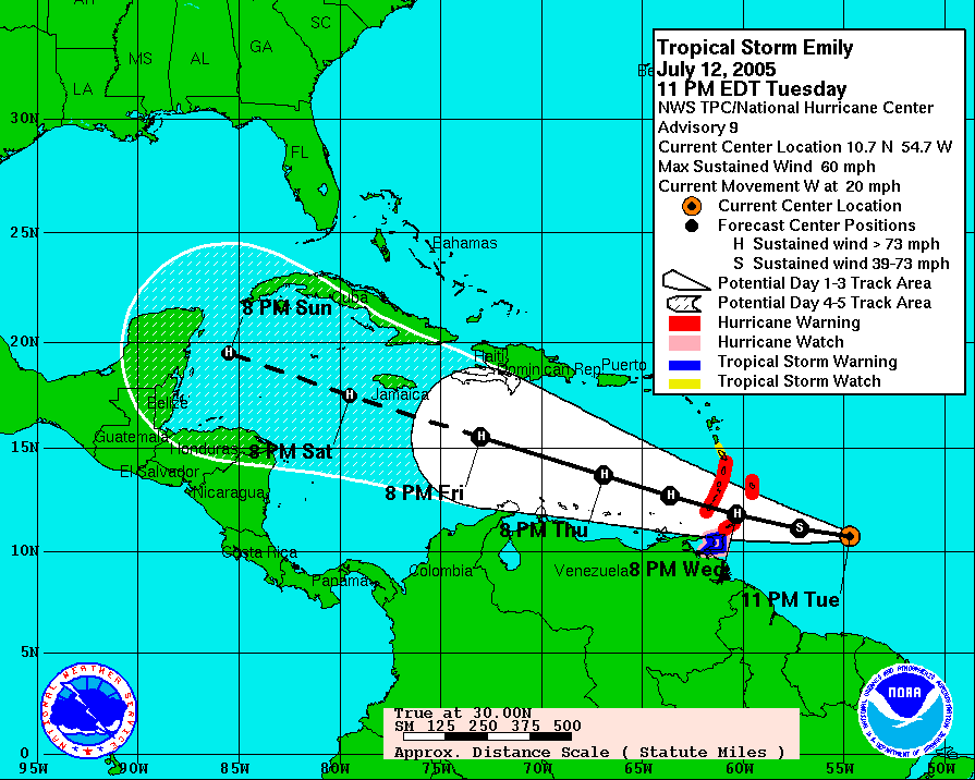
Hurricane Emily resources--the links are self-updating for handy reference:
NHC Hurricane Public Advisory Updates Currently published every three hours 5A, 8A, 11A, 2P, etc. ET.
NHC Hurricane Discussion Updates Published every 6 hours 5A, 11A, 5P, 11P ET
Caribbean Visible Loop (Only works during daylight hours)
Puerto Rico Long Range Radar Loop
Emily Forecast Track Archive Loop Great for reviewing the 3 day and 5 day historic track positions
WOW. As I said, interesting storm.
I'm reading the story about Hugo from youor link. Very interesting.
Hurricane Emily Discussion Number 23
Statement as of 11:00 am EDT on July 16, 2005
Emily has undergone another round of strengthening this morning. An
Air Force Reserve hurricane hunter aircraft indicates that the
central pressure has fallen to 943 mb...with 700 mb flight-level
winds as high as 148 kt. This would normally support surface winds
of 130-135 kt. However...the central pressure and eyewall
dropsondes do not yet support winds this high. Thus...the initial
intensity is set to 125 kt...which is in agreement with satellite
intensity estimates from TAFB and SAB.
The initial motion is 290/16...just a little to the right of the
previous advisory. Other than that...there is no change in the
forecast philosophy. Emily is on the south and southwest side of a
deep layer ridge extending from the Atlantic across Florida into
the northern Gulf of Mexico. Large-scale models agree this ridge
should build slowly westward...with perhaps a weakness remaining
over eastern Texas as a shortwave trough moves through the north
central U.S. Emily should continue west-northwestward for at least
48 hr...which should take the center near or over the Yucatan
Peninsula of Mexico. After that...the exact track depends on how
much weakness there is in the ridge over Texas. The model track
guidance has made a large shift to the left...or south...since the
previous runs...with the major dynamical models calling for the
ridge to fill in and landfall in east central Mexico. The official
track will also shift a little to the left...but not as far as the
guidance. Overall...the forecast track is in the northern edge of
the guidance envelope.
Emily has become well organized...with a well-defined 13 N mi wide
eye and a strong outer band in the northeastern quadrant. The
major factor controlling the intensity before landfall in Yucatan
will be hard to predict eyewall cycles...with perhaps some
influence from dry air trying to entrain into the Hurricane. Emily
should weaken over Yucatan...but is expected to regain major
hurricane intensity over the warm waters of the western Gulf of
Mexico.
Forecaster Beven
forecast positions and Max winds
initial 16/1500z 16.2n 77.3w 125 kt
12hr VT 17/0000z 17.1n 79.7w 130 kt
24hr VT 17/1200z 18.5n 83.0w 130 kt
36hr VT 18/0000z 19.9n 86.2w 130 kt
48hr VT 18/1200z 21.3n 89.4w 100 kt...inland
72hr VT 19/1200z 23.5n 94.5w 105 kt...over water
96hr VT 20/1200z 25.0n 99.0w 75 kt...inland
120hr VT 21/1200z 26.0n 103.5w 25 kt...inland dissipating
Well, it all depends on whether the ridge protecting Texas extends to the west for the next few days. If it degrades, we're in a heap of trouble.
Emily...DON'T MESS WITH TEXAS... ;o)
Looking like it might shoot the gap between yucatan and cuba.
Jamacia looks to have dodged this bullet, at least from a direct hit.
What an eye she has now. 9 miles wide yesterday and 13+ today iirc.
WTNT65 KNHC 161544
TCUAT5
HURRICANE EMILY TROPICAL CYCLONE UPDATE
NWS TPC/NATIONAL HURRICANE CENTER MIAMI FL
1145 AM EDT SAT JUL 16 2005
REPORTS FROM AN AIR FORCE RESERVE HURRICANE HUNTER AIRCRAFT INDICATE
THAT THE CENTRAL PRESSURE OF EMILY HAS FALLEN TO 940 MB AND THAT
MAXIMUM SUSTAINED WINDS HAVE INCREASED TO 150 MPH.
FORECASTER BEVEN
$$
Erik wrote Devil in a WHite City about the Chicago worlds fair and a murderer at the same time. It was mesmerizing and way more interesting than you would think.
My daughter baby sat for him when she was in high school. He was writing for either the Times or the Post and lived in Baltimore. She said he was nice.
Have been wanting to read about that storm. Let me know what you think of the book

What--if anything--can keep her from Cat 5 today?
Just damn. Gonna be a rainy end of next week here in San Antonio. What are your current thoughts about a Texas landfall?
Holey Guacamoley!!!!!!!!!!
"What--if anything--can keep her from Cat 5 today?"
Eye wall replacement... that's about it.
Shear is low.
http://cimss.ssec.wisc.edu/tropic/real-time/atlantic/winds/wg8shrZ.html
And lowering:
http://cimss.ssec.wisc.edu/tropic/real-time/atlantic/winds/wg8shtZ.html
So what's the morning's prognostication?
(Comes now Xenalyte, and for Count One of her action states that she is engaging in a bid to avoid going to work next week.)

It's going to be close... I guess I'm a little less confident than prior, because the models shifted south. The main trough from yesterday lifted out, but a remnant upper level low is still sittin in northern Mexico/S. TX. It will be interesting to see if that stays there, as we saw a similar thing happen with Dennis. That would be enough to kick the storm into TX.
Steering currents currently would bring it right to the border, if not a bit north... but the high is expected to build west. It's all about the weakness on the western periphery, hopefully the next model runs will make things a tad more clear.
This is kind of neat... Super Typhoon (cat 5) heading for Taiwan.
https://metoc.npmoc.navy.mil/jtwc/satshots/wp0505sair.jpg
That's impressive...
Taiwan is in a heap of trouble. That image reminds me of Isabel, when she was a big Bertha.
Disclaimer: Opinions posted on Free Republic are those of the individual posters and do not necessarily represent the opinion of Free Republic or its management. All materials posted herein are protected by copyright law and the exemption for fair use of copyrighted works.