Posted on 09/25/2005 6:14:46 AM PDT by Comstock1
The damage that has hit SW Louisiana and SE Texas is much worse than is being reported by the MSM. While there is very little in the way of a body count, houses and businesses by the hundreds have been destroyed. Entire communities in Cameron Parish have more than likely been erased from the map.
Here is link for some images from SW LA. You'll have to scroll down.
http://forum.lakecharles.com/ultimatebb.php?/ubb/get_topic/f/14/t/000023
No wonder Shep was losing it on the overpass...
A storm surge will be there as long as the storm keeps stacking the water up ahead of it, and the wind and tides can combine to increase the devastating effect.
You are right about the level of devastation, the effect is pretty much the same, with the added destructive force of the wind whipping waves into everything. That constant, rhythmic battering is more destructive in the long term than just an influx of water.
Over all, for a given depth, the storm surge is worse except in the regard that it can be predicted and avoided with a greater span of time to escape. Property suffers. People need not, except for the loss of what they cannot take with them.
to get an idea of the scale, those little sticks laying over at an angle are telephone poles.
to get an idea of the scale, those little sticks laying over at an angle are telephone poles.
All the houses are ... gone.
If you want to call it what it was, then you wouldn't call it a tsunami.
I think everything, housing wise in that area is gone.
This can not be said loud enough or often enough. MSM is infuriating and pathologically negligent with their smug "dodged a bullet" angle on Rita.
Looks like that working class community was completely wiped out.
These give you a good idea of the flooding in various areas. Each has a map of the pre-Rita and flood area for +5 +10 +15 +20.
I'd say go with the +15 maps. And I'd say those maps are accurate as they are based on elevation. Water and gravity obey no other master.
As for the wind and initial surge damage, well, let's just say that it will take the whores of the Hollywood citadel longer to get the picture, than just about anyone else.
Credit to JEFFERS for providing the originals I have posted below. TYIA.
http://photobucket.com/albums/y138/jeffers_mz/Rita/Beaumont/
http://photobucket.com/albums/y138/jeffers_mz/Rita/Lake%20Charles/
http://photobucket.com/albums/y138/jeffers_mz/Rita/Port%20Arthur/
http://i4.photobucket.com/albums/y138/jeffers_mz/Rita/BigPicture.jpg
I believe that photo is from Cameron Louisiana, and if so, the center of the photo was 3.5 miles from the outer edge of the right eyewall when Rita came ashore.
We don't know that that level of damage exists all along the coast. We do know that the surge/flooding reports came in well after landfall, which might mean that the damage is so severe that reports took a long time to get out, and which also might mean that the surge was impeded by wetland vegetation along a long slowly rising slope to the populated areas.
The best way to proceed in a case like this is to build the big picture slowly and cautiously. Bit by bit details will emerge from widely seperated areas and then we will begin to know what happened over the wider area.
You have to sort the information as to credibility and scope too. One man's tale of disaster might refer to his grass hut, swept away by an errant gust while the rest of the neighborhood stands fine, and at the opposite extreme, it might be the first harbinger of utter disaster.
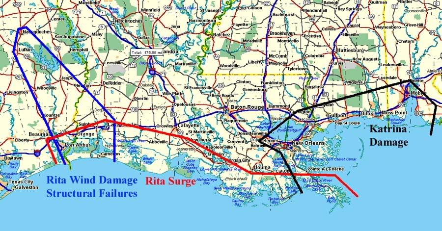
I expected that major surge damage would extend from Sabine Pass east to Vermillion Bay, and that significant surge damage would be experienced as far east as Caillon Bay as early as Thursday.
http://i4.photobucket.com/albums/y138/jeffers_mz/02J.jpg
This may well have been an optimistic assessment as the reports of flooding that I've seen extend further east to southeast of Houma. Of course the storm actually came ashore 17.25 miles east of that projection, and due to the geometry of the shoreline and the angle of the strike, the numbers and the anecdotal reports mesh pretty well.
(There's still a question of why the surge seemed to get deeper the further you got from the eye, but we've taken that as far as we can for now on another thread. Maybe more later on this.)
The media is always late to the party, usually between 12 and 48 hours, sometimes as late as three days or more. That's why Geraldo was in Galveston.
If there's a story, and film to sell ads at eleven, they'll show up.
Depend on it.
ONE of the reasons the MSM is not covering the devastation as quickly as we are, is that they are impeded in their
efforts by the flood, and the wind, as anyone else.
Right now, HELICOPTERS ARE NOT BEING WASTED ON TRANSPORTING MSM.
Politics. MSM news reporting isn't about news, it's about politics.


vs.
No stilts:

The enlargement shows classic eyewall damage. The water comes ashore with velocity, and being heavy, it breaks things. One the structure's integrity is lost, the wind and surf together remove the debris.
Though this may seem insensitive, I've seen worse. There's a lot of telephone poles still standing in that photo. Higher winds snap them off at ground level. Andrew took reinforced concrete. Katrina did too.
I imagined before the storm that this is what would happen to Sabine and Sabine Pass. The term I think I used was "vaporize". The storm came ashore a little east of east of the predictions, and Cameron got it instead. Well, maybe not instead, because I haven't seen damage reports from Sabine yet.
Another place that I haven't heard from that may have been hit pretty hard is Orange.
We'll see what turns up today, when there will be real assesment. I rarely expect any kind of comprehensive overview until landfall plus 24 hours, and that can vary depending on when during the diurnal cycle the storm comes ashore.
(O/T, company coming, I'll be off for a few hours, and will be back sometime this evening.)
Tell me FoxNews or anyone else can't spring for a charter airplane from FL or somewhere nearby and fly at low atltitude down the Lousiana Coast with a camera sticking out the window . . . they can do this, I've seen it done after Hurricanes on the outer banks, with non-media researchers footing the bill . . . the MSM are too freakin' lazy to go and find the news . . . they want it brought to them in a neat little package, preferably right to where they already have a reporter comfortably posted . . .
think about long island for a minute. while development on the barrier islands is limited (to a degree). the value of the properties all along the great south bay, and out to the Hamptons and Montauk is staggering.
I zoomed back from the view posted earlier to get the big picture.
This shows the likeliest path of destruction. The Storm and surge would follow the water, and the flooding would follow the path of least resistance. Lowest elevation.
http://www.terraserver.com/imagery/image_gx.asp?cpx=-93.324996&cpy=29.7975&res=64&provider_id=360&t=pan


The site where homes once stood in Holly Beach, is shown in this aerial view in the aftermath of Hurricane Rita Sunday, Sept. 25, 2005 in Cameron Parish

The aftermath of hurricane Rita is seen over Cameron, La., in this aerial photo made in a U.S. Coast Guard helicopter

Floodwaters surround damaged homes and businesses in the aftermath of Hurricane Rita Sunday, Sept. 25, 2005 in Cameron, La. (AP Photo/David J. Phillip)
Disclaimer: Opinions posted on Free Republic are those of the individual posters and do not necessarily represent the opinion of Free Republic or its management. All materials posted herein are protected by copyright law and the exemption for fair use of copyrighted works.