Skip to comments.
Hurricane Katrina, Live Thread, Part V
NHC - NOAA ^
| 28 August 2005
| NHC - NOAA
Posted on 08/28/2005 9:35:34 AM PDT by NautiNurse
Extremely dangerous Hurricane Katrina is bearing down on the North Central Gulf of Mexico. Mandatory evacuation of New Orleans is finally underway. Louisiana officials are warning of complete failure to levy systems, and pleading with people to leave low lying areas. For those who choose to stay, they are recommending picks and axes for breaking through to access their roofs during flooding.
Due to the size and intensity of this storm, all interests in the North Gulf of Mexico should be rushing hurricane preparations to completion.
The following links are self-updating:
Public Advisory Currently published every 3 hours 5A, 8A, 11A, 2P, etc. ET
NHC Discussion Published every six hours 6A, 11A, 6P, 11P
Three Day Forecast Track
Five Day Forecast Track
Navy Storm Track
Katrina Track Forecast Archive Nice loop of each NHC forecast track for both three and five day
Forecast Models
Alternate Hurricane Models via Skeetobite
Bouy Data Louisiana/Mississippi
Buoy Data Florida
Images:
New Orleans/Baton Rouge Experimental Radar Subject to delays and outages - and well worth the wait
Mobile Long Range Radar Loop
New Orleans/Baton Rouge Radar
Ft. Polk, LA Long Range Radar Loop
Northwest Florida Long Range Radar
Storm Floater IR Loop
Storm Floater Still & Loop Options
Color Enhanced IR Loop
Other Resources:
Hurricane Wind Risk Very informative tables showing inland wind potential by hurricane strength and forward motion
Central Florida Hurricane Center
New Orleans Web Cams Loads of web cam sites here. The sites have been very slow due to high traffic
New Orleans Music Online Couldn't resist--love that jazz
Golden Triangle Weather Page Nice Beaumont weather site with lots of tracks and graphics
Hurricane City
Crown Weather Tropical Website Offers a variety of storm info, with some nice track graphics
Live streaming:
copy/paste into player:
http://www.wjbo.com - BR radio station. Callers calling in and describing traffic etc.
WWL-TV/DT New Orleans (WMP) - mms://beloint.wm.llnwd.net/beloint_wwltv
WVTM-TV/DT Birmingham (WMP) - mms://a1256.l1289835255.c12898.g.lm.akamaistream.net/D/1256/12898/v0001/reflector:35255
WDSU-TV/DT New Orleans (WMP) - http://mfile.akamai.com/12912/live/reflector:38202.asx
Hurricane City (Real Player) - http://hurricanecity.com/live.ram
ABCNews Now (Real Player) - http://reallive.stream.aol.com/ramgen/redundant/abc/now_hi.rm
WKRG-TV/DT Mobile (WMP) - mms://wmbcast.mgeneral.speedera.net/wmbcast.mgeneral/wmbcast_mgeneral_aug262005_1435_95518
Hurricane Katrina, Live Thread, Part IV
Hurricane Katrina Live Thread, Part III
Katrina Live Thread, Part II
Hurricane Katrina Live Thread, Part I
Tropical Storm 12
| Category |
Wind Speed |
Barometric Pressure |
Storm Surge |
Damage Potential |
Tropical
Depression |
< 39 mph
< 34 kts |
|
|
Minimal |
Tropical
Storm |
39 - 73 mph
34 - 63 kts |
|
|
Minimal |
Hurricane 1
(Weak) |
74 - 95 mph
64 - 82 kts |
28.94" or more
980.02 mb or more |
4.0' - 5.0'
1.2 m - 1.5 m |
Minimal damage to vegetation |
Hurricane 2
(Moderate) |
96 - 110 mph
83 - 95 kts |
28.50" - 28.93"
965.12 mb - 979.68 mb |
6.0' - 8.0'
1.8 m - 2.4 m |
Moderate damage to houses |
Hurricane 3
(Strong) |
111 - 130 mph
96 - 112 kts |
27.91" - 28.49"
945.14 mb - 964.78 mb |
9.0' - 12.0'
2.7 m - 3.7 m |
Extensive damage to small buildings |
Hurricane 4
(Very strong) |
131 - 155 mph
113 - 135 kts |
27.17" - 27.90"
920.08 mb - 944.80 mb |
13.0' - 18.0'
3.9 m - 5.5 m |
Extreme structural damage |
Hurricane 5
(Devastating) |
Greater than 155 mph
Greater than 135 kts |
Less than 27.17"
Less than 920.08 mb |
Greater than 18.0'
Greater than 5.5m |
Catastrophic building failures possible |
TOPICS: News/Current Events; US: Alabama; US: Florida; US: Louisiana; US: Mississippi
KEYWORDS: hurricane; hurricanekatrina; katrina; tropical; weather
Navigation: use the links below to view more comments.
first previous 1-20 ... 421-440, 441-460, 461-480 ... 2,441-2,457 next last
To: janetjanet998
I grew up around tornadoes, they're bad but don't last long.
I think it's easy for some to forget that with a hurricane you're looking at hours of severe weather.
441
posted on
08/28/2005 10:27:47 AM PDT
by
tutstar
(OurFlorida.true.ws)
To: Beelzebubba
442
posted on
08/28/2005 10:27:55 AM PDT
by
filbert
(More filbert at http://www.medary.com)
To: don-o
There is a link upthread.
443
posted on
08/28/2005 10:27:56 AM PDT
by
JennysCool
(Non-Y2K-Compliant)
To: Normal4me
Is Anderson Cooper going too? I'm guessing he's still recovering.
To: All
When possible, please just post links to graphics and photos
To: Crawdad
Roll the top back.The roof of the Dome is a fixed roof - it won't "roll back."
446
posted on
08/28/2005 10:28:09 AM PDT
by
mhking
(The world needs a wake up call gentlemen...we're gonna phone it in.)
To: Beelzebubba
447
posted on
08/28/2005 10:28:12 AM PDT
by
Brian Mosely
(A government is a body of people -- usually notably ungoverned)
To: Torie
Why don't they have people drive school buses? I'm stunned, absolutely on the floor stunned, at the apparent lack of a preparedness by city officials.
448
posted on
08/28/2005 10:28:36 AM PDT
by
Peach
(The Clintons pardoned more terrorists than they ever captured or killed.)
To: Pravious
i've been telling everyone here (and getting flamed) that the white house communications team are idiots. not only is that speech about iraq poorly timed, but no one is listening to it anyway, its going to get zero attention.
anyway, back to the real topic at hand here.
To: in hoc signo vinces
They did their computer models and such with the nukes on a hurricane. No effect in most cases. Strengthened it in others. (Created more heat and low pressure.)
At least that is what I read awhile back.
450
posted on
08/28/2005 10:28:42 AM PDT
by
Ingtar
(Understanding is a three-edged sword : your side, my side, and the truth in between ." -- Kosh)
To: mware
People are bringing bags of food & clothing with them....is there a water tank in there so they will have drinking water? What about toilets? How long after this hits until supplies could be airlifted in?
451
posted on
08/28/2005 10:28:42 AM PDT
by
chgomac
To: brothers4thID
I'll predict that if the worst case scenario does unfold in New Orleans or elsewhere along the Gulf coast, coastal areas prone to hurricanes will become UNINSUREABLE for a long time to come.
Some estimates have potential material damage at 50 - 100 Billion dollars.
The insurance companies will simply cease providing coverage or coverage may exceed the cost of one's mortgage.
So then the government/taxpayer will foot the bill for oceanfront property or whole areas will simply depopulate due to the cost of living along the coast.
I never thought we would see such a possibility......
452
posted on
08/28/2005 10:28:49 AM PDT
by
Milwaukee_Guy
(Don't hit them between the eyes. Hit them right -in- the eyes!)
To: RightWhale
Not necessarily so. Some of the local level higher ups are corrupt and run dictatorial shops, they treat their staffs worse than shabbily and skim donations for personal use. I'm sure the majority are not that way but once you've known and talked to some staff, you'll be amazed and saddened. Still, they do some amazingly good work.
To: beyond the sea
90 degree water to pass over in the next hours.....
gawd, 90 degree water, like sitting in a jacuzzi.
454
posted on
08/28/2005 10:29:06 AM PDT
by
SunnySide
(Ephes2:8 ByGraceYou'veBeenSavedThruFaithAGiftOfGodSoNoOneCanBoast)
To: numberonepal
No, it was lousy timing and politically tone deaf (which is par for the course for the WH PR dept.) If the worst case scenario occurs, it will be the worst disaster in US history, and there will be screaming and finger-pointing regardless of the facts. The media will scream that Bush was so fixated on Iraq that he failed to adequately deal with the storm and implemented a better evacuation. And given that most of his speech was on Iraq, with less than a quarter on NO, while a frantic evacuation was taking place, a lot of people will agree. Not I, and IMHO the hurricane will probably move just enough east to avoid the worst case flooding, but it could end up being a huge PR blunder that paints a lasting political urban myth, similar to his father's price of bread snafu. Hopefully not, but it is a risk and wasn't a politically astute move. Rove's label of 'genius' continues to wear thin.
To: Normal4me; mhking; shield; IndyTiger; janetjanet998
NO ONE SHOULD ASSUME THEY WILL BE SAFE IN THE SUPERDOME WITH 175MPH SUSTAINED WINDS AND GUSTS TO 225MPH!
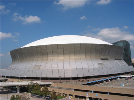
http://www.wwltv.com/local/stories/wwl092304thanh.1295648.html
"According to Curl, the assumption that the Superdome can withstand hurricane force winds is just that: an assumption. He says more analysis is needed to determine what the Dome can actually withstand because previous wind studies have become somewhat irrelevant since they did not factor in the new high-rise buildings around the Dome. “They create a wind tunnel effect and that needs to be tested. There were initial studies that indicated 130 miles per hour, but we don’t know,” said Curl. He adds that the Dome is not impervious to the same elements other areas would be exposed to."
To: dawn53
To: Aquamarine
That thing looks to me like it is still moving somewhat WNW. It does not look like it's going north yet.
458
posted on
08/28/2005 10:29:42 AM PDT
by
beyond the sea
("I was just the spark the universe chose ....." --- Cindy Sheehan (barf alert))
To: mhking
The roof of the Dome is a fixed roof - it won't "roll back."
What does that mean?
459
posted on
08/28/2005 10:29:42 AM PDT
by
hipaatwo
(Nazis Love Mother Sheehan)
To: NautiNurse
OK I Have now seen it all. Check out the BOLDED area of the following NWS advisory. They have removed al pretense and are saying that Katrina WILL come ashore as a CAT 5. I have never seen them actual put it out like that, usually they couch it with words like "has the Potential" etc etc
000
WTUS84 KLIX 281521
HLSLIX
LAZ038-040-050-056>070-MSZ080>082-281900-

HURRICANE KATRINA LOCAL STATEMENT
NATIONAL WEATHER SERVICE NEW ORLEANS LA
1015 AM CDT SUN AUG 28 2005

...HURRICANE KATRINA NOW A CATEGORY 5 HURRICANE PACKING SUSTAINED
WINDS OF 175 MPH...

...DIRECT STRIKE OF POTENTIALLY CATASTROPHIC AND LIFE THREATENING
HURRICANE EXPECTED...

...RUSH PROTECTIVE MEASURES TO COMPLETION AND LEAVE THE AREA
NOW!...

...HURRICANE WARNING IN EFFECT FOR SOUTHEAST LOUISIANA AND COASTAL
MISSISSIPPI FROM MORGAN CITY EAST TO THE ALABAMA FLORIDA BORDER....

...DANGEROUS HURRICANE KATRINA MOVING WEST NORTHWEST IN THE GULF OF
MEXICO...

...AREAS AFFECTED...
IN SOUTHEAST LOUISIANA...THE FOLLOWING PARISHES

ASSUMPTION...ST JAMES...ST JOHN THE BAPTIST...ST CHARLES...ST
BERNARD...TERREBONNE...ORLEANS...JEFFERSON...PLAQUEMINE...
LAFOURCHE...ST TAMMANY...TANGIPAHOA...LIVINGSTON.

IN COASTAL MISSISSIPPI...THE FOLLOWING COUNTIES
HANCOCK...HARRISON...JACKSON

...WATCHES AND WARNINGS...
A HURRICANE WARNING IS IN EFFECT FROM EAST OF MORGAN CITY EAST TO THE
ALABAMA-FLORIDA BORDER AREA. THIS INCLUDES THE METRO NEW ORLEANS
AREA...AND THE MISSISSIPPI COAST.

...STORM INFORMATION...
AT 10 AM CDT...THE CENTER OF HURRICANE KATRINA WAS LOCATED NEAR
LATITUDE 26.0 NORTH...LONGITUDE 88.1 WEST OR ABOUT 225 MILES
SOUTHEAST OF THE MOUTH OF THE MISSISSIPPI RIVER.

MAXIMUM SUSTAINED WINDS ARE NEAR 175 MPH...WITH HIGHER GUSTS.
HURRICANE KATRINA IS A CATEGORY FIVE HURRICANE ON THE SAFFIR
SIMPSON SCALE. SOME MINOR FLUCTUATIONS IN STRENGTH IS POSSIBLE
DURING THE NEXT 24 HOURS. HOWEVER...KATRINA IS EXPECTED TO
MAKE LANDFALL AT A CATEGORY 5 HURRICANE PACKING SUSTAINED
160 MPH WINDS. HURRICANE KATRINA IS MOVING TOWARD THE WEST-NORTHWEST
NEAR 12 MPH AND A GRADUAL TURN TOWARD THE NORTHWEST IS EXPECTED
LATER TODAY.

...PRECAUTIONARY/PREPAREDNESS ACTIONS...
PROTECT YOU AND YOUR FAMILYS LIVES. FOLLOW LOCAL EMERGENCY MANAGERS
RECOMMENDATIONS AND LEAVE HURRICANE WARNING AREA NOW BEFORE WEATHER
CONDITIONS WORSEN. RESIDENTS OF SOUTHEAST LOUISIANA AND COASTAL
MISSISSIPPI SHOULD RUSH PREPARATIONS FOR THE LANDFALL OF A
CATASTROPHIC HURRICANE LATER TONIGHT AND EARLY MONDAY...WITH DAMAGING
HURRICANE FORCE WINDS AND HIGH STORM SURGE.

MANDATORY EVACUATION ORDERS ARE IN EFFECT FOR MOST SOUTHEAST
LOUISIANA PARISHES AND COASTAL MISSISSIPPI COUNTIES. RESIDENTS SHOULD
FOLLOW EVACUATION RECOMMENDATIONS FROM LOCAL PARISH OFFICIALS.

...STORM SURGE FLOOD AND STORM TIDE IMPACTS...
KATRINA IS EXPECTED TO MAKE LANDFALL ALONG THE NORTHERN GULF OF
MEXICO COAST AS A CATASTROPHIC LIFE THREATENING HURRICANE. WHILE
EXACT LOCATION LANDFALL IS UNCERTAIN AT THIS TIME...SIGNIFICANT AND
LIFE THREATENING STORM SURGE 18 TO 22 FEET ABOVE NORMAL IS POSSIBLE
NEAR AND TO THE RIGHT OF THE LANDFALL AREA. A FEW AREAS MAY
EXPERIENCE STORM SURGE FLOODING AS HIGH AS 25 FEET ALONG WITH LARGE
AND DANGEROUS BATTERING WAVES NEAR AND TO THE EAST OF WHERE THE
CENTER MAKES LANDFALL. RESIDENTS IN AREAS PRONE TO STORM SURGE
FLOODING SHOULD LEAVE NOW! HEED EVACUATION RECOMMENDATION FROM LOCAL
EMERGENCY MANAGEMENT OFFICIALS. SECONDARY ROADS OUTSIDE LEVEE
PROTECTION WILL LIKELY BECOME IMPASSABLE THIS EVENING AND TONIGHT.

...WIND IMPACTS...
EAST TO NORTHEAST WIND OF 20 TO 25 MPH SHOULD CONTINUE OVER
THE REGION TODAY...THEN INCREASE LATE THIS AFTERNOON AND CONTINUING
TONIGHT. TROPICAL STORM FORCE WINDS ARE LIKELY TO OVERSPREAD THE
COASTAL AREAS THIS EVENING AND THE REMAINDER OF THE INLAND AREAS BY
EARLY MONDAY MORNING. HURRICANE FORCE WINDS ARE LIKELY TO BEGIN BY
MIDNIGHT AND MOVE INLAND MONDAY MORNING AND AFTERNOON.

KATRINA IS FORECAST TO MOVE ASHORE AS CATEGORY FIVE HURRICANE...
SIMILAR IN STRENGTH TO HURRICANE CAMILLE IN 1969. WINDS ASSOCIATED
CATEGORY 4 AND CATEGORY 5 HURRICANE CAN TOTALLY DESTROY MOBILE
HOMES...AND CAUSE MAJOR DAMAGE TO EVEN WELL CONSTRUCTED BUILDINGS.
HIGHER WIND SPEEDS ARE LIKELY TO BE EXPERIENCED ON UPPER FLOORS OF
TALL BUILDINGS CAUSING DAMAGE.

...RAINFALL...
RAINFALL TOTALS OF 8 TO 10 INCHES...WITH ISOLATED MAXIMUM AMOUNTS OF
15 INCHES...ARE POSSIBLE NORTH AND SOUTH OF LAKE PONTCHARTRAIN
AND THE MISSISSIPPI COAST.

...NEXT UPDATE...
THE NEXT LOCAL STATEMENT WILL BE ISSUED AROUND 130 PM CDT.
460
posted on
08/28/2005 10:29:42 AM PDT
by
commish
((Montgomery, AL) Freedom Tastes Sweetest to Those Who Have Fought to Preserve It)
Navigation: use the links below to view more comments.
first previous 1-20 ... 421-440, 441-460, 461-480 ... 2,441-2,457 next last
Disclaimer:
Opinions posted on Free Republic are those of the individual
posters and do not necessarily represent the opinion of Free Republic or its
management. All materials posted herein are protected by copyright law and the
exemption for fair use of copyrighted works.
FreeRepublic.com is powered by software copyright 2000-2008 John Robinson