Posted on 12/10/2004 1:00:11 PM PST by blam
Following the Trail of Ancient Louisianians
December 9, 2004
by Amélie A. Walker
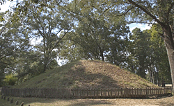
A mound at Marksville, one of the state-owned sites on the Louisiana Ancient Mounds Trail. (Mark J. Sindler/LA Office of Tourism)
Known for Mardi Gras, jazz, and Cajun culture, Louisiana also has a wealth of Native American sites dating to as early as 4000 B.C. The most obvious remains of ancient peoples are the many mounds that can be seen throughout the state, in cotton and soybean fields, hidden in woods, or even under houses. In all, there are more than 700 mound complexes or individual mounds in Louisiana. Built over millennia, they include some of the oldest and best-preserved such structures in North America.
Mound building began around 6,000 years ago, at a time when people were becoming more sedentary, though not yet involved in agriculture, and continued until the period of European contact. The first mounds may have marked seasonal homes with abundant resources for nomadic hunter-gatherers, but mounds were used for different purposes at different times and places. Burials have been found in some mounds, while archaeologists have identified house patterns and found domestic objects on mounds that were apparently residential sites. Others likely served religious purposes. Whatever their use, these earthen structures are a reminder of cultures past, a heritage that should be protected and shared.
To celebrate Louisiana's Native American mounds, a series of historical markers has now been installed, creating the Ancient Mounds Trail. Currently made up of 37 sites that can be viewed from public highways, the trail's purpose is to educate the public about the state's earliest people while also diversifying and expanding tourism. The mounds are a lesser-known aspect of Louisiana's past, one that the state would like to better publicize and make accessible. More visitors would be especially welcome in mound-rich northeastern Louisiana, the region that currently receives the smallest number of tourists.
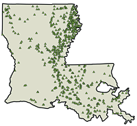
Ancient mounds are found throughout Louisiana, but they are most concentrated in the northeast. (Courtesy Louisiana Division of Archaeology)
The idea for a trail came from the desire of the state's Division of Archaeology to recognize the sites and make those that could be seen from the right of way available to the public. Northeast Louisiana Regional Archaeologist Joe Saunders and Reca Jones, the woman who discovered the Middle Archaic site of Watson Brake and is now an assistant in the Northeast Regional Archaeology Program, started the process. They began identifying the mound sites that are viewable from highways and contacting the landowners to see if they would be willing to participate in a trails program. The Division of Archaeology secured Federal Highway Administration funds from the Department of Transportation and Development in Louisiana to mark the sites with historical markers and to develop a guidebook that would provide more information for those wishing to follow the trail.
Participation of private landowners was critical to the success of this project. A few of the sites--Poverty Point, Marsden, and Marksville--are owned by the public, but most mounds are in private hands. The Ancient Mounds Trail is part of a greater Heritage Area, which itself is mostly made up of mounds on private property that landowners have agreed to protect. The state has been quite successful in landowner cooperation and stewardship, and there are about 80 sites and 86 owners involved so far. The private owners have agreed to become stewards, whereby they protect the sites from looting, farming, and other activities that would damage the mounds or other archaeological remains. There is no payment involved, each participating landowner gets a certificate of appreciation and recognition. There are means by which they can obtain an easement for their site with the Louisiana Archaeological Conservancy, providing them with tax benefits, but this is not part of the program's objective.
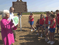
Reca Jones and Tom Eubanks talk to a school group at Balmoral Mounds, a privately owned site on the trail. (Mark J. Sindler/LA Office of Tourism)
When asked how long it's taken to get the trail together, State Archaeologist Thomas Eubanks said, "It's one of these things. You can't do the guidebook until you have markers in the ground, and you can't have the markers in the ground until the landowners agree. It's just taken a lot more time than we originally envisioned it would take." On top of all this is the still-in-progress process of verifying the information they have about the sites so that the historical markers are accurate and the guidebook can be written. This includes coring many of the mounds to get carbon samples for dating and to determine whether they were constructed in multiple stages. It also entails surveying the sites for the guidebook maps. The mapping is also necessary for the landowners to know the extent of the sites they are protecting that extend beyond the mounds themselves. The information on the trail's mounds must be as correct and up-to-date as possible, as a historical marker is permanent once it is created and installed. Eubanks says it has taken six or seven years since the project began to get to the point of putting the markers in the ground.
(Courtesy Louisiana Division of Archaeology)
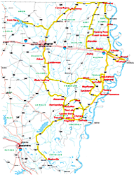
The Louisiana Ancient Mounds Trail is about a five-hour tour by car with stops at the museums at Poverty Point in West Carroll Parish and Marksville in Avoyelles Parish, which serve as the hubs to the trail. Individuals or groups with an interest in learning more about mound sites in Louisiana can start near Epps at the Poverty Point State Historic Site. There they will be introduced to mound building by watching a video, looking through the museum, and touring the site itself. They can then drive to see the other sites with a better understanding of the mounds and the people who constructed them. The next state-owned site on the trail is Marsden, a group of mounds incorporated into Poverty Point Reservoir State Park and recently opened to the public. Though no full visitor's center is planned at Marsden, there will eventually be more interpretative materials available there, and visitors can arrange for guided tours. Following the trail from northeast to central Louisiana, most of the rest of the historical markers are on privately owned mounds. These sites can be viewed from highways or to the extent each landowner allows (these markers will all have "No Trespassing" signs on their posts). The tour ends at Marksville, where there is another interpretive center. (See larger map and images.)
Louisiana's Division of Archaeology hopes the trail will enhance appreciation for the mounds' significance and highlight the need to protect them. Because the state will never be able to own all of these sites, it is important for landowners and the general public to understand that the preservation of this cultural resource is to a great extent in their hands. "If we don't work toward private protection of archaeological sites, we're really losing the resource base as a whole," says Eubanks, who stresses educating the public in the long-term benefit of saving the sites. "What we're doing is enhancing protection by reinforcing with the landowners the importance of the sites, so that the public can understand that looting or digging at the site is not responsible."
The 50-page interpretive guide and map of the Louisiana Ancient Mounds Trail will be published in January 2006. Until then, brochures and a trail map are available at Poverty Point and Marksville or by contacting the Louisiana Division of Archaeology at archaeology@crt.state.la.us or visiting their website.
Amélie A. Walker, a native of Louisiana, is online editor and webmaster for ARCHAEOLOGY. She wishes to thank Louisiana's Department of Culture, Recreation, and Tourism for its generous assistance.
Thanks. That’s the one I was going to post, got started, and FR won’t allow it due to copyright complaints.
Never knew about this place. I own a fishing camp on this lake not too far from here.
https://www.crt.state.la.us/dataprojects/archaeology/moundsguide/scottplace.html
Scott Place Mounds
Nice.
As a sidebar, it’s interesting how even remote, sparsely inhabited places tend to have pretty specific placenames.
D’Arbonne Bayou, which drains in the Ouachita River just north of Monroe, LA, was a significant transportation artery before railroads. We are in the area known today as “piney woods,” but quite a bit of cotton was grown in the region way back when
https://shilohtocanaan.com/2016/09/01/steamboats-made-history-in-parish/
Steamboats Made History in Parish
September 1, 2016
Written by Gene Barron
From the 1840s until the advent of the railroads in Union Parish, steamboats were the main method of transporting goods and travel into and from Union Parish. Although travel on the Bayous was hazardous and sporadic to say the least, these boats were the best mode of shipping cotton, stave bolts and other raw materials produced in Union Parish to markets outside the parish. They also served as a mode of transportation for passengers.
The sternwheelers that plied the Bayous of D’Arbonne and Big Corney were considerably smaller than those of the Mississippi, Red River and Ouachita Rivers. Most were about 24 feet wide and about 100 feet long and able to transport 400 or so bale of cotton at a time. The life of these steamboats was on average only a few years. The hazards of the Bayous took their toll and the danger of fires from sparks from the smoke stacks was great.
Nice!
https://www.lsu.edu/mediacenter/news/2022/08/19gg_ellwood_lsucampusmounds.php
New Research Shows LSU Campus Mounds as the Oldest Known Man-made Structures in North America
August 19, 2022
LSU Campus Mounds
BATON ROUGE – New research reveals more information about the LSU Campus Mounds, including the discovery of thousands of years old charred mammal bone fragments and a coordinated alignment of both mounds toward one of the brightest stars in the night sky. This new information offers more insight into the oldest known man-made structures in North America.
The two large, grassy mounds that are about 20 feet tall, on LSU’s campus, are among the more than 800 man-made, hill-like mounds in Louisiana, built by ancient indigenous people. While many mounds in the region have been destroyed, the LSU Campus Mounds have been preserved and are listed on the National Register for Historic Places.
“There’s nothing known that is man-made and this old still in existence today in North America, except the mounds.”
Brooks Ellwood, LSU Department of Geology & Geophysics Professor Emeritus
This study was published in the American Journal of Science by Yale University.
Ellwood and colleagues collected sediment cores from the two mounds that are located on LSU’s campus along Dalrymple Drive to learn more about them. The cores revealed layers of ash from burned reed and cane plants, as well as the burned osteons. Radiocarbon dating of the layers of material indicates the mounds were built over thousands of years. These findings show that people began to build the first mound about 11,000 years ago. The scientists think that sediment for the southern mound, which they’ve named “Mound B,” was taken from a location immediately behind LSU’s Hill Memorial Library, because there is a large depression in the ground there. The mound was built up over a few thousand years, layer by layer, to about half of its current height.
The layers of ash and charred microscopic bone fragments may indicate the mound was used for ceremonial purposes, which included burning reed and cane plants to make large, hot fires that would have been too hot for cooking. The scientists do not know what type of mammals were cremated or why. However, they found many microscopic, charred bone fragments, known as osteons, the building blocks of large mammal bones, in the ash beds in both LSU Campus Mounds.
Then, around 8,200 years ago, the southern Mound B was abandoned. Tree roots found in the 8,200-year-old sediment layer indicate that the mound was not used for about 1,000 years. Also around 8,200 years ago, the northern hemisphere experienced a major climate event with temperatures suddenly dropping on average by about 35 degrees Fahrenheit, which lasted about 160 years.
“We don’t know why they abandoned the mounds around 8,200 years ago, but we do know their environment changed suddenly and dramatically, which may have affected many aspects of their daily life,” Ellwood said.
Then, around 7,500 years ago, the indigenous people began to build a new mound just to the north of the first mound. However, this time, they took mud from the floodplain where the entrance to LSU’s Tiger Stadium is currently located, which at that time was an estuary. With this mud, they built the second mound, “Mound A,” layer by layer, to about half of its current height. Mound A contains mud that is saturated with water, which liquefies when agitated. As a result, Mound A is unstable and degrading, which is why it is critical to stay off the mounds to preserve them.
According to the new analyses of the sediment layers and their ages, it looks like indigenous people cleared the abandoned first-built Mound B and began to build it up to its current height before completing Mound A. Both mounds were completed around 6,000 years ago and are similar in height.
The crests of both mounds are aligned along an azimuth that is about 8.5 degrees east of true north. According to LSU astronomer and study coauthor Geoffrey Clayton, about 6,000 years ago, the red giant star Arcturus would rise about 8.5 degrees east of north in the night sky, which means it would have aligned along the crests of both LSU Campus Mounds. Arcturus is one of the brightest stars that can be seen from Earth.
“The people who constructed the mounds, at about 6,000 years ago, coordinated the structures’ orientation to align with Arcturus, seen in the night sky at that time,” Ellwood said.
Disclaimer: Opinions posted on Free Republic are those of the individual posters and do not necessarily represent the opinion of Free Republic or its management. All materials posted herein are protected by copyright law and the exemption for fair use of copyrighted works.