Click here: to donate by Credit Card
Or here: to donate by PayPal
Or by mail to: Free Republic, LLC - PO Box 9771 - Fresno, CA 93794
Thank you very much and God bless you.
Posted on 11/02/2026 9:34:17 PM PST by SunkenCiv
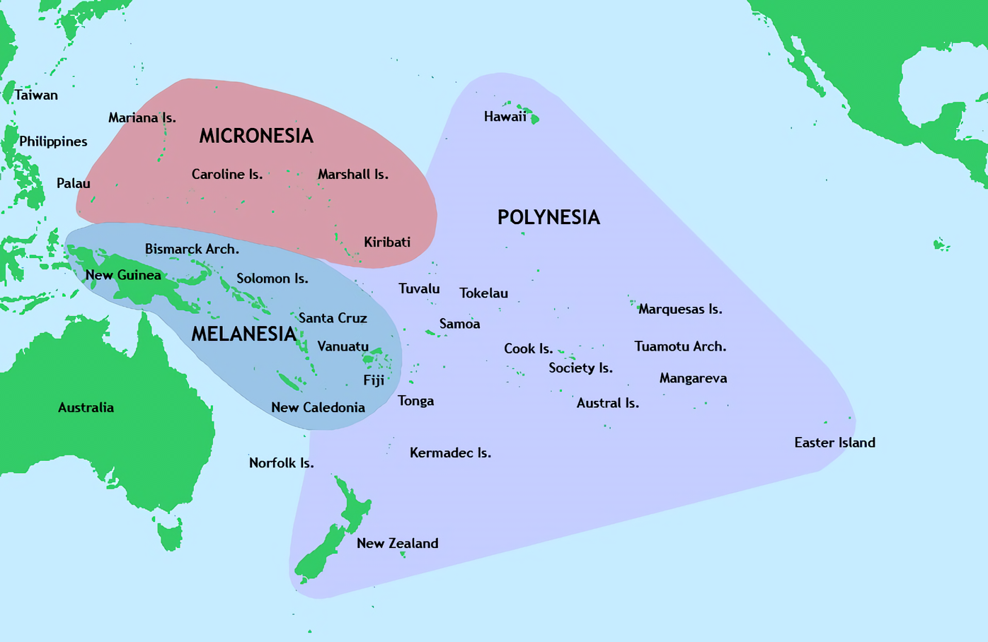
Science Alert reports that Alexander Ioannidis of Stanford University and his colleagues analyzed the genomes of more than 1,000 people who live in French Polynesia; 12 genomes from individuals on the island of Rapa Nui; and the genomes of people native to Hawaii, Samoa, Tonga, and Tahiti. First, the researchers isolated segments of Polynesian ancestry with machine learning, and then they applied an identity by descent method, which can identify common ancestors of living people and people from the past. The study shows that people traveled across Polynesia in small populations, sometimes resulting in a genetic bottleneck of reduced genetic variation that can increase the odds of the occurrence of harmful mutations known as the founder effect. People who became Native Hawaiians are thought to have experienced a series of bottlenecks as they traveled long distances on small double-hulled catamarans. "Hawaii is the only Polynesian island in the Northern Hemisphere, so it's a long way from everything," Ioannidis explained. The study also suggests that Native Hawaiians are most closely related to the people of Rapa Nui. The two islands are more than 4,000 miles apart, and each one is about 2,000 miles from another island. Both populations were also found to be related to people on Mangareva Island, which may have been their launching point in French Polynesia, Ioannidis concluded. For more on early Hawaiian history, go to "Letter from Hawaii: Inside Kauai's Past."
(Excerpt) Read more at archaeology.org ...
|
|
Click here: to donate by Credit Card Or here: to donate by PayPal Or by mail to: Free Republic, LLC - PO Box 9771 - Fresno, CA 93794 Thank you very much and God bless you. |
At two corners of the Polynesian Triangle, which has a much more benign reputation compared with another famous geographical triangle.Kahuroa/Wikipedia via The Planetary Society
We're back in the sweet spot -- the digs and such that went on earlier in the year are now getting results published.
The Ice Age almost made the world walkable ten thousand years ago. It would have been a lot easier to access these islands.
Gee, this tropical island paradise we’re living on is no good. Let’s jump into a boat and wander around millions of square miles of uncharted ocean on the slim chance we stumble upon another tropical island paradise.
The middle of the pacific would not have been walkable
The middle of the pacific would not have been walkable
The middle of the pacific would not have been walkable
Tell Jonty30.
During the Ice Age, much of the world was walkable, because thecsea levels were 400ft lower. In some places, at worst, itvwas a relatively short canoe ride.
You can verify this yourself.
Tell Gemini. :)
A **400-foot (approx. 120 to 125 meters) drop** in global sea levels corresponds to the climatic conditions of the **Last Glacial Maximum (LGM)** roughly 21,000 years ago. During this period, massive volumes of Earth’s water were locked up in continental ice sheets, exposing nearly **27 million square kilometers** of shallow continental shelves.
This newly exposed terrain—roughly equivalent to the combined landmass of North America and Europe—fundamentally transformed global geography. Here is a breakdown of what became accessible on foot or via short canoe hops:
### 1. Major Continental Land Bridges (Fully Walkable)
* **Beringia (Asia to North America):** A massive land bridge hundreds of miles wide emerged between Siberia and Alaska. Humans and megafauna walked freely between the Eurasian and North American continents.
* **Doggerland (Europe and the British Isles):** Great Britain and Ireland were entirely landlocked extensions of mainland Europe. You could walk on foot from modern-day France, Belgium, or the Netherlands straight across the dry bed of the North Sea to London and beyond.
* **Sundaland (Southeast Asia):** The shallow waters of the South China Sea disappeared, fusing the Malay Peninsula, Sumatra, Java, Borneo, and Bali into a massive southern extension of the Asian continent.
### 2. Expanded Megacontinents & Basin Dry-Outs
* **Sahul (Australia, New Guinea, and Tasmania):** While Australia and Asia remained separated by deep-water oceanic trenches (the Wallace Line), Australia, New Guinea, and Tasmania were joined into a single giant continent called Sahul.
* **The Persian Gulf Basin:** The entire Persian Gulf was a dry, fertile river valley. The Tigris and Euphrates rivers flowed together through the basin before emptying into the Indian Ocean far to the south.
* **The Mediterranean and Black Sea:** While the deep Mediterranean basin retained its major seas, many island groups were connected or dramatically expanded (e.g., the Italian peninsula stretched much further, and the Adriatic Sea was largely a flat plain).
### 3. Coastal Expansions (Short Canoe or Walking Access)
* **North America’s Coasts:** The Atlantic and Gulf of Mexico continental shelves dried out. Florida more than doubled in physical surface area, and the coastlines of the Eastern Seaboard shifted outward by tens of miles.
* **East Asia:** The Yellow Sea and East China Sea floors were exposed plains, connecting the Korean Peninsula directly to mainland China.
### Summary of Impact
In total, a 400-foot drop opened up vast travel corridors across the globe. While deep oceanic trenches (such as those separating Sundaland from Sahul) still required maritime travel, an ancient traveler could have walked continuously from the tip of South Africa, through Europe and Britain, across Asia into Alaska, and all the way down to the depths of modern-day Indonesia without ever needing a ship.
Im not saying every island would have been so easily accessible, but much of it was at the time.
One wonders what fraction of those who attempted those crossings survived the trip to a new island chain and what motivated them in the attempt. Mistakes were certainly made, both fortuitous and catastrophic.
In Melanesia yes, but not any of the Hawaian Islands.
Primitive tribes would have been resource poor. The nomadic lifestyle requires upwards of 50 sqmiles per person. Itvwas either fight for what you have or find another place to live.
The research I've seen suggests a wide range in the relative degree of prosperity v. impoverishment.
There would be a wide range, but they wouldn’t have had our ability to create resources, because they generally lived off the land as is.
You are correct, I had Grok research it.
If the oceans were 400 feet lower, the Hawaiian Islands would have been about 20-30 miles more accessible, out of 3800 miles from Asia.
They’re volcanoes from deep water.
Yes they are, but to get to them requires to go through some deep water, even if 400 ft lower. The Ice Age dodnt make these really accessible.
Combine flock cameras with time travel and everything you ever did is now recorded.
Disclaimer: Opinions posted on Free Republic are those of the individual posters and do not necessarily represent the opinion of Free Republic or its management. All materials posted herein are protected by copyright law and the exemption for fair use of copyrighted works.