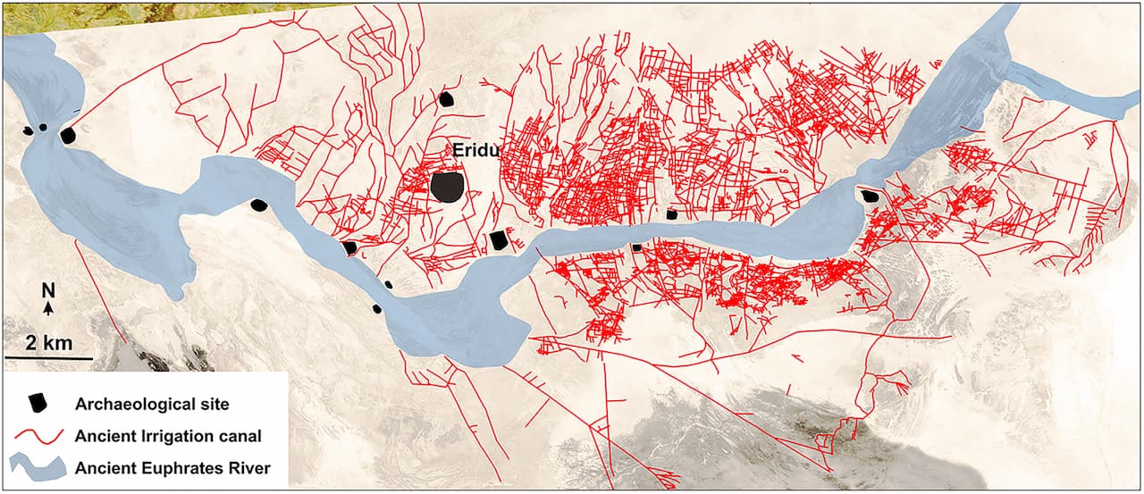
The reconstructed irrigation canal network in context with the ancient Euphrates riverbed and the archaeological sites of the Eridu region. The base map is a Corona satellite image.Credit: Jaafar Jotheri et al, Antiquity
Posted on 03/18/2025 6:28:57 PM PDT by SunkenCiv
Recent research by a multidisciplinary team of archaeologists and geologists has revealed that the Eridu region of southern Mesopotamia, inhabited from the sixth to the first millennium BCE, boasts one of the oldest and most well-preserved irrigation networks.
Led by geoarchaeologist Jaafar Jotheri from Durham University, the research team uncovered an extensive water management system that predates the first millennium BC, offering valuable insights into the irrigation practices of ancient farmers.
The Eridu region of southern Mesopotamia, located in present-day Iraq, is one of the best-preserved ancient archaeological sites, having been occupied from the sixth until the early first millennium BC. While our understanding of the irrigation and farming methods used in this ancient city has largely relied on indirect evidence, such as cuneiform tablets, recent research has revealed a vast and well-developed network of irrigation canals that predates the early first millennium BC...
In contrast to other regions, the Eridu area was abandoned following a shift in the Euphrates River's course, allowing its archaeological landscape to remain relatively intact...
By combining geological maps, satellite imagery, drone photography and fieldwork, researchers identified over 200 primary canals directly connected to the ancient Euphrates. Additionally, more than 4,000 smaller branch canals were mapped, linked to over 700 farms.
(Excerpt) Read more at arkeonews.net ...
The reconstructed irrigation canal network in context with the ancient Euphrates riverbed and the archaeological sites of the Eridu region. The base map is a Corona satellite image.Credit: Jaafar Jotheri et al, Antiquity
World’s first city that wasn’t submerged by the glacier melts.
Sixth millennium BC?
Doubt.
That, and the need to defend their food supply from outsiders, and probably to keep order when there were disagreements about who had which land. The flood plain was the breadbasket of Sumerian cities, but the property lines had to be surveyed before each planting season. This led to their development of surveying (which led to geometry) as well as record keeping (which led to writing) and maybe astronomy (to track when to plant).
Well, yeah. :^) The Sumerians considered Eridu the first city in that region, but Samuel Noah Kramer pointed out that the place names (cities and rivers) of the Sumerians didn’t have Sumerian names. The Sumerians preserved the place names and hence recorded small fragments of whatever language had been spoken in Mesopotamia before their arrival. The rest of the language is unrecorded and presumably will remain unknown.
The Sumerians thought all cities were founded by the gods, a superstition which may account for their reluctance to a) found cities of their own and b) rename stuff.
submerged city example in India:
https://en.wikipedia.org/wiki/Dv%C4%81rak%C4%81#Submergence
Evidently, they were not woke.
Eridid?..............
Eridgation.
Disclaimer: Opinions posted on Free Republic are those of the individual posters and do not necessarily represent the opinion of Free Republic or its management. All materials posted herein are protected by copyright law and the exemption for fair use of copyrighted works.