
Posted on 03/21/2022 10:05:17 AM PDT by nickcarraway
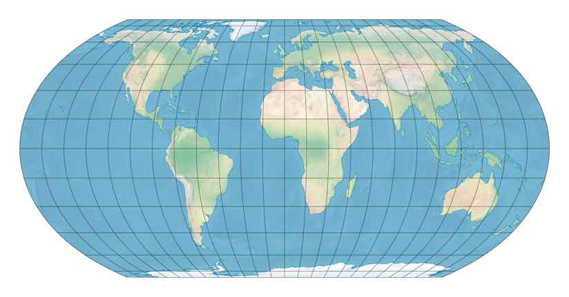
ideo showing the true size of Russia compared to Africa has gone viral on TikTok as social media users learn about the misrepresentation of scale on many world maps.
First posted in late February, the video had gained around 8.5 million views as of March 14 with just under 400,000 likes.
In the video, footage of an interactive map shows an outline of Russia, which at first appears to dominate a huge section of the map. However, as the outline is dragged down towards the continent of Africa and the equator, Russia begins to shrink. By the time the outline of Russia is placed on the equator, it is significantly smaller than it appeared at first and is dwarfed by the continent of Africa.
(Excerpt) Read more at msn.com ...
They likely wouldn’t. Nevertheless… https://www.foxnews.com/media/donald-trump-greenland-white-house.amp
Ever hear of Australia?
Perhaps that's why some believe that the melting of Greenland's ice will result in everything being flooded.
Lots of folks according to the glowing MSM takes on spending my tax dollars unwisely (marathon sessions of congress?)....oh yeah and whenever one of the Harry Reids of the world pass on (beacon of American politics?)....or when race baiters go off on some “social justice” issues (going all out to make the world a more equitable place?)....
Unfotunately, it’s the teachers union that keeps ignorant and incompetent “teachers”. Teachers should be teaching kids to be learners, that was the idea of the classical education, to give people the skills to educate themselves throughout their life. Not to insure that someone had tenure.
So… if you mix in black equity Africa is the largest continent of all the world!
Pluto was a planet, then it got cancelled. The same could happen to Australia.
Get a globe. Trace Russia on a piece of cellophane/sandwich wrap flattened over it. Flatten it back out over Africa. (Or trace Africa and flatten it over Russia.) Now you have a more direct comparison
Or... Wikipedia says that Russia has a landmass of ~6.6 million square miles. South America is ~6.8 million square miles. Africa is 11.7 million square miles. Russia is almost the size of South America.
Except, South American has a lot of warm water ports.
Cute video, but the point of it is what? The continent of Africa has 11.7 million square miles. The country of Russia, which encompasses the entire northern area of Asia and part of the continent of Europe, is 6,612,073 sq mi. Comparing a continent to a country is misleading. Russia has the largest land mass of any country in the world (11%). Canada is next, then China, and the USA is fourth.
For much of my life, I never gave much thought to the actual relative sizes of various continents or land masses, even though I was well schooled in the pitfalls of various types of maps (such as those seen in a Mercator projection) but it wasn’t viscerally imprinted in me until I went inside the Christian Science Mapparium located in Boston.
(I know, it is a Christian Science thing, but...it is quite impressive. Read about it at: https://en.wikipedia.org/wiki/Mapparium)
It is a giant earth globe, made of glass, three stories tall, lit from the outside with lights, and you walk inside to view the globe as if you were at the center of the earth.
It is a remarkable viewpoint because when you are looking at a globe...the size difference between say, Africa and North America is evident, but...it doesn’t hit you the same way because of the act of viewing it on a globe from the outside tends to...isolate what you are looking at on the globe.
You have to often rotate the globe a little to see a different part.
But from the inside of the Christian Science Mapparium, the size differential not only readily apparent, it was astonishingly apparent.
Africa seemed to take up nearly half the globe. It seemed to dwarf everything else. That really stuck with me over the years, that perspective.
Is there some corrected way to measure? Russia and Canada have significant land mass that is barely habitable or uninhabitable. 90% of Canadians live within 100 miles of the U.S. border.
Africa is big. Took me a day to fly from Djibouti to Malawi and that is only about 1/2 way.
72% of Canadians live below the 49th parallel. 33% f Canadians actually live below the 45th parallel. 80% of Canada is uninhabitable.
Interesting post (and thanks for link).
80 % Canada is uninhabitable. Guessing NOT from being too warm.
It tipped over.....................
Disclaimer: Opinions posted on Free Republic are those of the individual posters and do not necessarily represent the opinion of Free Republic or its management. All materials posted herein are protected by copyright law and the exemption for fair use of copyrighted works.