Posted on 02/06/2022 5:03:02 PM PST by Right Wing Vegan
The March 2022 North American blizzard, alternatively named Winter Storm Mandy, was the costliest and most intense extratropical cyclone ever recorded in the Atlantic. It developed as an elongated trough over the northwestern Caribbean Sea on March 4, and struck the Yucatan Peninsula before moving east-northeast, impacting Florida and the Bahamas before paralleling the east coast of the United States.
A combination of the absorption of a second, weaker low-pressure system near Bermuda, an unusually sharp sea surface temperature gradient along its path, a rapidly cooling upper troposphere, and the presence of an anomalously strong jet stream resulted in the cyclone beginning to undergo explosive intensification while located east of North Carolina. The system reached its peak intensity while located east of the Delmarva peninsula, with a minimum central pressure of 908 mbar (26.81 inHg) and maximum sustained winds of approximately 125 mph (201 km/h), making it the most intense tropical cyclone on record worldwide at the time, a record that was surpassed less than three years later by the November 2025 Bering Sea cyclone, but one which remains standing in the Atlantic Ocean.
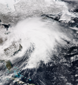
As the cyclone approached land, it weakened somewhat, but remained extremely potent. An eye feature was present on satellite imagery, and major hurricane-force sustained winds were present in the northeast quadrant of an eyewall-like feature that had developed. Hurricane-force winds extended over 100 miles from the center, and gale-force winds covered an exceptionally large area, extending from the Bahamas to Atlantic Canada.
Late on March 9, the cyclone made landfall north of Atlantic City, New Jersey with a minimum central pressure of 912 mbar (26.93 inHg) and maximum sustained winds of approximately 115 mph (185 km/h). Much of the region was devastated by very high snowfall totals, storm surge, and extreme winds. Anomalously, the system spawned dozens of tornadoes across the Mid-Atlantic and New England, and frequent lightning was observed in some locations, especially those in proximity of the center of circulation.
As the cyclone moved inland, it weakened, albeit slowly, and even regions hundreds of miles from the coastline experienced hurricane-force sustained winds, in some cases for hours on end. During the afternoon of March 10, it emerged into Lake Ontario, where it managed to strengthen somewhat before making landfall north of Hamilton, Ontario. The presence of a strong jet stream to the south and a strong ridge to the north caused the system to undergo a large cyclonic loop, and it again emerged into the Atlantic during the afternoon of March 11. Late the following day, it made landfall in northwestern Nova Scotia. On March 13, the weakening cyclone made a final landfall in a sparsely populated region of Quebec's Côte-Nord region after briefly crossing over the nearly uninhabited Anticosti Island, and proceeded to rapidly weaken before dissipating on March 16. Meteorological history
On March 9, an elongated trough of low pressure with a minimum central pressure of 1012 mbar (29.88 inHg) developed over the northwestern Caribbean Sea. The system slowly deepened as it drifted to the northwest, and a region of gale-force winds surrounded the developing center of circulation by the time it made landfall on the Yucatan Peninsula early on March 11. As the system tracked to the east-northeast, over the Gulf of Mexico, the rate of intensification began to increase, and it had deepened to 987 mbar (29.15 inHg) by the morning of March 12, when it passed over the Florida Keys.
During the evening of March 12, as the cyclone moved over the Bahamas, it began to undergo rapid intensification, with its minimum central pressure falling to 968 mbar (28.59 inHg) as a field of hurricane-force sustained winds developed around the center. At this time, a secondary low, with a minimum central pressure of 1008 mbar (29.77 inHg) began to develop well southwest of Bermuda, along a cold front associated with the primary cyclone. The strengthening was enhanced by an unusually sharp sea surface temperature gradient along the system's path, a rapidly cooling upper troposphere, and an anomalously strong jet stream with maximum wind speeds approaching 275 mph (443 km/h).
On the afternoon of March 13, the cyclone, which now had a minimum central pressure of 957 mbar (28.26 inHg), absorbed the secondary low to its southeast, which had a minimum central pressure of 988 mbar (29.18 inHg). This merger triggered a period of extremely explosive intensification. By the morning of March 14, the minimum central pressure of the cyclone had fallen to 915 mbar (27.02 inHg), and a field of major hurricane-force sustained winds began to develop around an eye feature that had become present on satellite imagery.
Around noon on March 14, a weather buoy near the center of circulation measured a barometric pressure of 908 mbar (26.81 inHg) and sustained winds of 125 mph (201 km/h), with a maximum gust of 157 mph (253 km/h) before failing, making the system the most intense extratropical cyclone on record worldwide, at the time -- a record which still stands in the Atlantic. Maximum wave heights in the region were estimated to approach 100 feet (30.5 m), and dangerous storm surge began to impact the coast of North America, while increased swells were present as far from the center of circulation as the United Kingdom.
A tremendous barometric pressure differential existed between the cyclone and a high-pressure area centered over northern Manitoba, which had a maximum central pressure of 1041 mbar (30.74 inHg). This caused the existence of an extremely large field of gale-force winds, which extended from Quebec to the Bahamas on a north-south axis and Indiana to the central Atlantic on a west-east axis. Hurricane-force winds extended over 300 miles (483 km) from the center, and major hurricane-force winds were present in an eyewall-like feature that had developed within the cyclone, giving it an appearance similar to that of a tropical cyclone on satellite imagery.
Late on March 9, the cyclone made landfall near Atlantic City, New Jersey with a minimum central pressure of 912 mbar (26.93 inHg) and maximum sustained winds of approximately 115 mph (185 km/h). An automated weather station operated by the Philadelphia, PA/Mount Holly, NJ National Weather Service (NWS) office reported a maximum gust of 160 mph (257 km/h) before failing. A storm surge in excess of 25 feet (7.6 m) inundated many coastal regions. In the eyewall of the cyclone, frequent lightning was observed, and snowfall rates exceeded 12 inches (31 cm) per hour, at times.
As the cyclone advanced inland, it slightly weakened, albeit rather slowly. Anomalously, it spawned over two dozen tornadoes in multiple states, the strongest of which being an EF2 tornado that touched down near Rome, New York, heavily damaging a Walmart and multiple homes. An automated weather station in Cicero, New York reported a minimum central pressure of 936 mbar (27.64 inHg) and sustained winds of 83 mph (134 km/h).
I know we’re behind a lot of times, but it’s still February here in Kentucky.
Thanks for the heads up time traveler
Now do the July 4, 2024 UFO landing
And…?
You think that was big?
You shoulda seen last August when I got soaked by pop-up thundershower “Bruce”
I’m impressed. Not one word about Climate Change. Just a storm.
Haha. Author wrote this at least as far back as November 2020. At least that is the date of the first comment there.
Yes. To make the report sound like a real (real fake) media report, there has to be blame on global warming somewhere!
Areas to the north and east of me will pick up 40-60 inches easy and I'll be sitting here with barely 20. Just you wait and see.
Around here we call that “Tuesday”.
Oh no....not a storm in March...
And in the middle of it all the Russians detonated an EMP over Mahwah, New Jersey, and an asteroid strike wiped out Saint Louis. April 3rd saw the first landings of Chinese troops in the Pacific Northwest.
For reference: The Blizzard of 1949
https://www.youtube.com/watch?v=gl6Iz4dXGdg
I actually know someone from Mahwah, NJ.
Perhaps suggest it to the blogger. I didn't write the thing. It just appealed to me because I like snow, ice and blizzards.
You omitted April 2, when the Mayor of Portland gave they keys of the city to PLA Gen. Bai Dins Pao
Everyone died.
Or will die in that particular space-time continuum.
I guess.
Film at 11:00.
March 2017 North American blizzard - Wikipedia
The March 2017 North American blizzard was a major late-season blizzard that affected the Northeastern United States, New England and Canada, dumping up to 3 feet (36 in; 91 cm) of snow in the hardest hit areas, mainly New York, Vermont, New Hampshire and Southern Quebec. Forming out of an extratropical cyclone near the Northwest, the storm system dived into the northern portions of the United States, dropping light to moderate snow across the Great Lakes, Upper Midwest on March 11–12 before reaching the Ohio Valley the next day. It later coalesced into a powerful nor'easter off the East Coast, producing a swath of heavy snowfall across a large portion of the Northeast. The storm was given various unofficial names, such as Winter Storm Stella, Blizzard Eugene, and Blizzard of 2017.[
Disclaimer: Opinions posted on Free Republic are those of the individual posters and do not necessarily represent the opinion of Free Republic or its management. All materials posted herein are protected by copyright law and the exemption for fair use of copyrighted works.