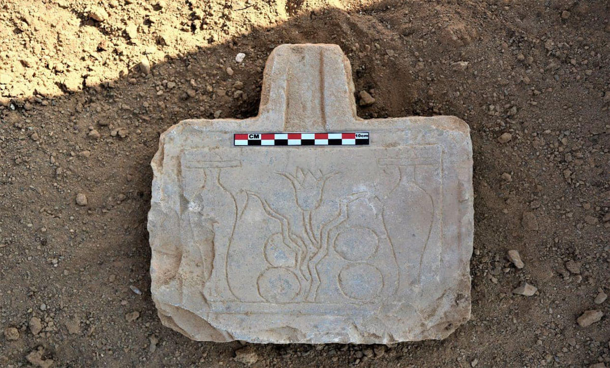
Engraved stone, Jabal Sukari, EgyptEgyptian Ministry of Tourism and Antiquities
Posted on 03/05/2025 4:48:30 PM PST by SunkenCiv
La Brújula Verde reports that the Egyptian Ministry of Tourism and Antiquities completed a two-year excavation and preservation project of an ancient mining camp at Jabal Sukari near the Red Sea. Archaeologists were under pressure to complete the project as the site is currently endangered by modern mining activities. The Egyptian team uncovered a vast gold processing complex that dates back 3,000 years, as well as a settlement inhabited by those who worked at the mine. The mining facility included specialized factories for extracting the gold from quartz veins, which has provided new information about ancient methods of obtaining and producing pure gold. The site included grinding and crushing stations, filtration and sedimentation basins, and clay furnaces for smelting. Adjacent to the industrial works, archaeologists located dwellings, workshops, administrative buildings, temples, and even baths. Inscriptions on various pieces of pottery and stone were found to be written in hieroglyphs, Demotic, and Greek, which highlights the linguistic and cultural diversity of the community working and residing there at the time. Some of the more sensitive architectural remnants were relocated about two miles outside of the modern mining zone for their protection, while a full-scale replica of the entire site was also built in that location to attract tourists.
(Excerpt) Read more at archaeology.org ...
[snip] The world's oldest known geological map is a nine-foot-long papyrus from the Egyptian village of Deir el-Medina, home to the New Kingdom craftsmen who worked in the Valley of the Kings. Created by Amennakhte, the chief scribe of the royal necropolis, the papyrus depicts a dry riverbed called the Wadi Hammamat in Egypt's eastern desert. The wadi had been used for quarrying and mining for centuries, and as a route connecting the Nile Valley to the Red Sea for millennia. No map would have been needed for general travel, according to Egyptologist Andreas Dorn of Uppsala University and linguist Stéphane Polis of the University of Liège. Instead, the papyrus was created as a commemorative record of a pharaonic expedition, perhaps during the reign of Ramesses IV (r. ca. 1153 -- 1147 B.C.), to a bekhen-stone quarry. Bekhen-stone, or greywacke, was prized for use in high-quality sculptures. To distinguish types of stone, Amennakhte employed dark brown to represent bekhen-stone, pink for deposits of granite and gold, and spots for alluvial deposits. [/snip]The Goldmine Papyrus | Jarrett A. Lobell | Archaeology Magazine | Mapping the Past | May/June 2019
Engraved stone, Jabal Sukari, EgyptEgyptian Ministry of Tourism and Antiquities
James Carville is gone!?
Doc Brown sure got around.
You ever notice that there was no setting for location?
It's as if all of history went down in Hill Valley.
For God’s sake, don’t tell the Hoffmans.
Great Scott!
And of course, “Hill Valley” is like “jumbo shrimp”.
I wonder if this corresponds to the description of the headwaters of the Pishon River in Genesis 2:11-12.
Since it would be flowing into the confluence of the Tigris and Euphrates, no.
https://israelbylocals.com/pishon-river/
Remember sea level rise since the Pleistocene, also that there was a waterway from the southeast Saudi Peninsula to the Gulf. Then there is the coherence in stone spear points from the southern Peninsula to Ethiopia, suggesting the same people capable of crossing a very shallow Bar Al Mandeb (Rose 2010).
The tidal pattern in Red Sea is very much like a bathtub, rising in the middle and falling on the ends then reversing (a boring topic, no?). It might have been possible to cross on foot.
So there's reason to ask the question I rose.
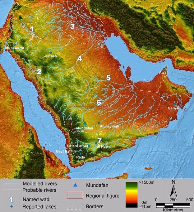
AM, the image above is by Crassard et al. (2013) but posted from BBC. It is hosted as public access on plos.org. I don't know what the copyright status would be in this case but suspected we're OK there.
Thanks, nice map. The wadi labeled “4” appears to be the one discussed as the Kuwait River (Pishon).
My hypothesis is the mining is of latrines of the Jews after Moses lead them across the Red Sea.
The latrines would hold the gold that Arron made the Jews eat and drink of the golden calf that was ordered destroyed.
As Roseann Rosanndanna said…Never mind.
Emily Litellla.
The Hebrew says the “Gihon” ‘encompasses the land of Kush,’ probably the river exiting the system of lakes and marshlands now amid the largest sand dune system on earth today (Wiseman and Farouk El-Baz, 2007). Also called the Empty Quarter River, the system enclosed that part of Kush which had migrated across the land bridge at the bottom of the Red Sea (bab el Mandeb, may have been dry at that time as the bridge crest was probably subjected to tidal erosion because of the differences between diurnal Red Sea and semidiurnal Arabian Sea tides of up to 2m). Recovered hunting points indicate that the two areas of “Kush” on either side of the Red Sea strait were crafted by the same people (Clark 1954, Rose, 2010).
The existence of botanical refugia capable of supporting human populations during the late Pleistocene desiccation is documented along both the Nile and beneath the Persian Gulf (Rose, 2010). Were those peoples primarily living by horticultural means, then Cain came before Abel, as the story describes.
Disclaimer: Opinions posted on Free Republic are those of the individual posters and do not necessarily represent the opinion of Free Republic or its management. All materials posted herein are protected by copyright law and the exemption for fair use of copyrighted works.
