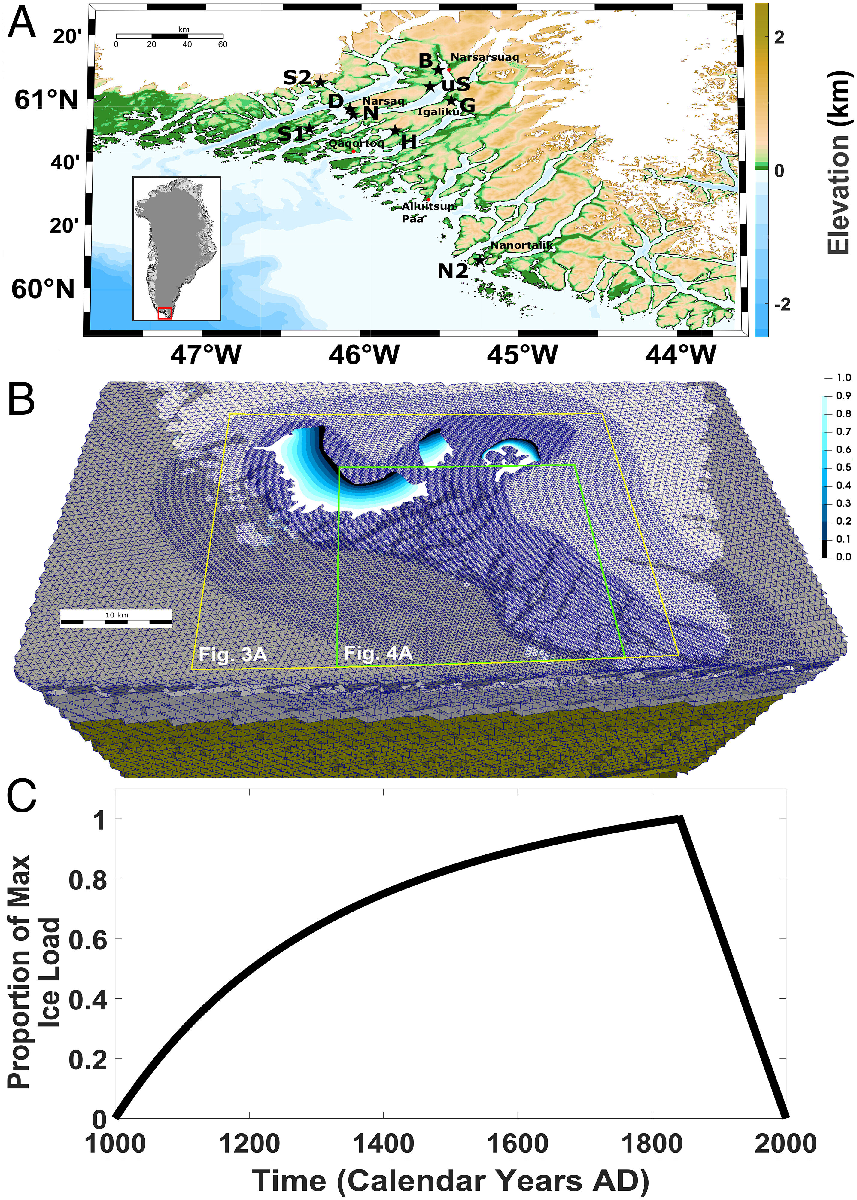
Regional setting and ice history. (A) The Eastern Settlement of Southern Greenland. The inset shows the entirety of Greenland; dark gray depicts grounded ice cover at present, light gray is land, and white is ocean. Eight black stars show locations of the Viking sites considered herein and also Nanortalik, where Late Holocene relative sea-level data have been collected (11). B is Brattahlid, D is Dyrnaes, G is Gardar, H is Hvalsey, N is Narsaq, N2 is Nanortalik, S1 is Site 1, S2 is Site 2, and uS is Undir Solarfjollum. (B) The tetrahedral grid across Southern Greenland used in the sea-level simulation (top 72 km of Earth’s interior is shown in light gray; surface shading reflects grid resolution and is discussed in Material and Methods Section 3B) with ice mask (blue to white gradient) overlain. The ice mask is estimated from ref. 12. The yellow box shows an area encompassing the Eastern Settlement and the area of ice growth (the same area is shown in Fig. 3A). The green box shows an area with several important Viking settlements, where coastal flooding is assessed (also seen in Fig. 4A). For more details, Section 3A. (C) Time-varying growth for our ice history, normalized to a maximum value of 1.0, and adapted from refs. 13–15. DOI: 10.1073/pnas.2209615120Credit: Proceedings of the National Academy of Sciences (2023)
1 posted on
04/23/2023 6:28:10 PM PDT by
SunkenCiv
To: SunkenCiv
Damn SUVs...damn gas ovens!
To: SunkenCiv
Oh noes!! Global warming!!
4 posted on
04/23/2023 6:32:28 PM PDT by
mass55th
("Courage is being scared to death, but saddling up anyway." ~~ John Wayne )
To: SunkenCiv
The departure of these Viking settlers coincided with the beginning of the period known as the Little Ice Age, which had a particular impact on the North Atlantic. But while cooling and freezing might seem likely to lower sea levels, a variety of factors combined to have the opposite effect in Greenland. So, the scientific consensus is basically, "It's whatever."
Colder? That's Global Warming and rising seas.
Warmer? That's Global Warming and rising seas.
Remarkably steady? That's Global Warming and rising seas.
5 posted on
04/23/2023 6:32:42 PM PDT by
ClearCase_guy
(“You want it one way, but it's the other way”)
To: SunkenCiv
Climate Change, is there anything it isn’t responsible for?
6 posted on
04/23/2023 6:35:48 PM PDT by
EvilCapitalist
(81 million votes my ass.)
To: SunkenCiv
What if there was sudden land mass subsidence in Martha’s Vineyard, and in Nantucket. Our climate Czar and Brandon Junta friends would need new luxury beach houses. Quelle dommage.
To: SunkenCiv
Oh Bullcrap. These “researches” don’t have a clue why the Vikings left.
9 posted on
04/23/2023 6:40:45 PM PDT by
Organic Panic
(Democrats. Memories as short as Joe Biden's eyes)
To: SunkenCiv
We are not talking about steel skyscrapers here. We are talking about wooden huts. If they at risk of flooding the Vikings would have moved the huts further up hill.
Greenland was settled during the Medieval Warm Period, when melting glaciers made the land well watered and green, and abandoned when it got too cold to farm there.
10 posted on
04/23/2023 6:40:53 PM PDT by
SauronOfMordor
(The rot of all principle begins with a single compromise.)
To: SunkenCiv
Impossible. President Trump was not President.
To: SunkenCiv
Those darn Viking Sport Utility Ships were a cause of global warming.
13 posted on
04/23/2023 6:48:23 PM PDT by
Freedom_Is_Not_Free
(America -- July 4, 1776 to November 3, 2020 -- R.I.P.)
To: SunkenCiv
Sea levels have been rising for 7000 years.
14 posted on
04/23/2023 6:49:47 PM PDT by
arthurus
(covfefe /)
To: SunkenCiv; All
However, a closer look at previously published geomorphological and paleoclimate data and the researchers' modeling of ice-sheet growth suggested that the opposite occurred in Greenland, In other words, based on a computer model.
These computer models are a classic example if garbage in, garbage out.
Models are not science. They reflect the researchers desires.
To: SunkenCiv
17 posted on
04/23/2023 6:58:20 PM PDT by
cdcdawg
(Our empire of sodomy is failing as it should. How else could it go? )
To: SunkenCiv
I can imagine diesel powered ships and coal fired generating stations were responsible for the Viking abandonment. Those dang fossil fuels will make the water rise anywhere.
19 posted on
04/23/2023 7:00:50 PM PDT by
redfreedom
(You can vote your way into socialism, but you may have to shoot your way out.)
To: SunkenCiv
21 posted on
04/23/2023 7:07:13 PM PDT by
TangoLimaSierra
(⭐⭐To the Left, The Truth is Right Wing Violence⭐⭐)
To: SunkenCiv
BS, cold is what drove the vikings from Greenland. Little ice age started around 1400 and it got real cold.
23 posted on
04/23/2023 7:10:27 PM PDT by
jpsb
To: SunkenCiv
The weather, plus running out of fuel. Real estate agents hyped a place that disagreed with buyers who managed to view the property. Women. Rumors. News from home. Signs. Islamic wars required warriors back home.
25 posted on
04/23/2023 7:19:01 PM PDT by
linMcHlp
To: SunkenCiv
Sea levels had risen in Greenland but not in Europe? In 1066, William the Conqueror had to wait to cross the English channel due to unfavorable winds. I’d say they left because it was cold and no food.
But hey, I’m no expert.
27 posted on
04/23/2023 8:13:34 PM PDT by
Brasky
(You miss every shot you never take.)
To: SunkenCiv
What the researchers found was striking: Not only were sea levels drawn up by gravity, other factors—including the subsidence of Greenland's land mass—made the settlement more prone to flooding. In other words, the Viking settlements were causing Greenland to start tipping over, so they left?
-PJ
38 posted on
04/24/2023 12:17:33 AM PDT by
Political Junkie Too
( * LAAP = Left-wing Activist Agitprop Press (formerly known as the MSM))
To: SunkenCiv
If true, Greenland ought to be underwater by now................
44 posted on
04/24/2023 5:49:20 AM PDT by
Red Badger
(Homeless veterans camp in the streets while illegal aliens are put up in hotels.....................)
To: SunkenCiv
The old adage “All computer models are wrong, though some are useful”, has been my guiding light in a 60-year career using computer models. This one makes me highly suspect. For starters, the verbiage says 3 meters of sea level rise, while the chart indicates one and a half meters. They also show the sea level ‘rise’ to be at the start of the Little Ice Age, rather than at the end. How could the so-called gravity effect of the accumulating ice start before the ice actually accumulated?
Color me highly skeptical. This one seems to me to be not one of the not ‘useful’ models.
45 posted on
04/24/2023 6:04:52 AM PDT by
norwaypinesavage
(The power of the press is not in what it includes, rather, it's in that which is omitted.)
FreeRepublic.com is powered by software copyright 2000-2008 John Robinson
