Skip to comments.
The Largest Ancient Man Made Canal System on Earth
earthepochs.blogspot.co.uk ^
| April 3, 2014
| johnmjensen jr
Posted on 01/03/2015 4:10:32 PM PST by Fred Nerks
From my Free Web Book 'AncientCanalBuilders.com'
The largest wide-array man made (or at least non natural) structure in the world is in fact an ancient terra formed systems of agricultural-aquaculture canals in Northwestern Botswana and Northeastern Namibia, north of the Kalahari Desert in Southern Africa. Obviously quite ancient, the canal systems no longer provide free flowing water throughout its 105,000 mile array, but many sections show obvious intention to provide cross sectional irrigation.
These canals are too evenly spaced over too large an area to be any kind of natural formation. Based on entry and exit points, it is readily apparent this system is a very large, controlled agronomy array and/or aquaculture system. Its age is defined by the overgrown nature of the canals, as well as some areas that are covered over with drift and sand erosion.
The entire complex covers an area about equal in size to the State of Arizona in the USA. The canals are an integrated system of apparent irrigation and agricultural (and probably aquaculture) design. The system is about 350 miles in width and about 300 miles in depth. (For the remnants still visible.) This system represents roughly 67 MILLION acres of sustainable agriculture. Given the sophistication of design, it is entirely plausible to assume an above average yield, i.e. feeding well over 90 persons per acre on an annual basis. The system may or may not have provided a sustainable aquaculture (marine farming) environment. I have no reason to suspect that it did not.
Given the size and scope of this complex, (canals are about 1 mile apart on average) and collectively are roughly 350 X 300 miles in a rough rectangular format. (At least the observable parts) There could be, and probably is, much more to this complex than what is visible to the naked eye. Right now, we can identify ancient cultivation of roughly 105,000 square miles.
One square mile = 27,878,400 square feet, or 640 acres, so the entire complex had a sustained producing land mass of (640 acres x 105,000 square miles) or > 67,200,000 acres. (That is 67 MILLION acres)
One linear mile of canal had (750' width x + >12' depth x 5,280') = 47,520,000 cubic ft of water per linear mile.
Entire canal length (105,000 miles x 47.5 million cubic ft per mile) = 5,000,000,000,000 (That's 5 TRILLION) cubic feet of water in the canals. It would be an incredible waste of time and effort to irrigate >105,000 square miles of sustainable agriculture land, and not use the 5 trillion cubic feet of water circulating in the canals for aquaculture farming. I don't think the builders were that stupid.
Different estimates of the numbers of people this sustainable system would supply varies widely, though it is generally accepted that a system like this, if properly managed would provide a complete annual diet for somewhere between 60 to 120 people per acre. Which means this system was in fact providing food for an average of about 5 Billion people.
This array is in fact the largest non natural artifact on the Planet. It can be clearly viewed unaided from the International Space Station at roughly 230 miles up, which cannot be said for any other non natural feature on Earth.
I would suggest that depth of canal(s) must have been significant to compensate for general slight variations in elevation. There seems to be an average elevation variation of about 60', sometime more, and sometimes less.
Your comments are welcome, or you can contact me here:
johnmjensenjr@gmail.com 321-614-5040
First brought to my attention by Gary Schoening Here is his original Vimeo post: http://vimeo.com/64351951
TOPICS: Chit/Chat
KEYWORDS: africa; agriculture; ancientcanals; animalhusbandry; botswana; canals; godsgravesglyphs; irrigation; kalahari; kalaharidesert; namibia; remotesensing
Navigation: use the links below to view more comments.
first previous 1-20 ... 141-160, 161-180, 181-200, 201-211 next last
To: gleeaikin
“The parallel lines visible on the Google Earth map do NOT have the characteristics of any of the dune processes shown. They have two slightly raised lines with a narrow sunken area between, or two slightly raised lines with a wide flat area between. In other words, the progression is raised, narrow sunken, raised, wide flat, raised, narrow sunken, raised, wide flat, raised, narrow sunken, raised, wide flat, etc. etc. etc. for dozens or more repetitions. Where are there any generally accepted as natural dune features like that???”
You are badly mistaken. One of the illustrations correctly describes how bidirectional winds form longitudinal dunes that tend to merge into the so-called linear dunes. What you fail to understand is your misperception of the Google images due to optical illusions and the degraded nature of the ancient dunes which are now represented by little more than consolidated soils with gentle rises and dips in a generally flat landscape. What you are misperceiving as canals is due in great part to the coloring of the soils by the sorting of the soils in the remnant bases of the dunes and valleys between the dunes, embayment of moisture between the slight rises, and coloration due to the plant life exploiting moisture and their contribution of material to color the soils. When you drive across those so-called stripes you misperceive as canals, you will be hard put to find evidence of a canal. Instead, you are seeing the remnants of the soils after 30,000 to 60,000 years of dune and other erosion and the formation of topsoils in an arid environment.
“In addition the ridges are not high like dunes tend to be especially when spaced that far apart.”
You wouldn’t expect them to be so. The dunes were relatively broad and low to begin with, and tens of thousands of years of erosion and degradation have reduced them to some very low rolling terrain covered in vegetation that stabilized the soils and colored them in the subsequent millennia.
“Look at the Google Map link at Comment 48. Go in close, 100 and 200 feet. Look at a lot of them in different areas. No high dunes, and always the wide, narrow, wide, narrow pattern.”
Try driving on the road across those dune stripes. Geological samples have been taken from inside the linear dunes. Can you even manage to see the dunes and valleys from the road? What you think you see in the Google satellite views are illusions which disappear when you look at them from closeup on the ground.
To: gleeaikin; SunkenCiv
WHAT ARE THESE GIANT STRIATED GEOGRAPHICAL FEATURES... Image Identification

Near the Okavango Delta. They appear to have a spatial frequency of about 1 mile and cover thousands of square kilometers...
Those are the dunes of the Kalahari desert.
The northern dune field is characterised by broad linear dunes of approximately 25 m high and 1.5 to 2 km apart and extending as much as 200 km (Grove, 1969; Lancaster, 1980). Degradation of the dunes in this field increases towards the north (Flint and Bond, 1968; O’Connor and Thomas, 1999). The eastern field is characterised by degraded linear dunes with up to 50 km of unbroken length (Flint and Bond, 1968) and by barchan dunes and transverse dunes to the west of Makgadikgadi (Grove, 1969; Mallick et al., 1981).
Helgren and Brooks (1983) suggested that the large linear dunes were formed during the Early Pleistocene or late Tertiary and Cooke (1980) suggested deposition of the sands during intervals of Lower-Mid Pleistocene aridity. Although several other dates for conditions favouring dune formation have been suggested by various other workers (e.g. Lancaster, 1981, Van Zinderen Bakker, 1982, Deacon et al., 1984; Heine, 1981, 1982, 1990) there were not many absolute dates for the formation of dunes other than a dune-base peat date of 19 680 ± 100 years BP in the Makgadikgadi (Thomas and Shaw, 1991a) and a powder calcrete within a dune near Etosha dated at 3 510 BP (Rust,1984).
SOURCE
And there we seem to have it. It's been an interesting journey.
162
posted on
01/04/2015 8:31:10 PM PST
by
Fred Nerks
(Fair Dinkum!)
To: WhiskeyX; All
Have you yourself actually driven through these areas, like down route 88?
To: Fred Nerks; SunkenCiv; All
Since nearly all the lines are oriented to the Okavango, then they would not need cross channels. I would be interested to know to what extent all this is flooded in the rainy season. Anyone have a Google Earth or similar site that would cover that season?
To: gleeaikin
“Have you yourself actually driven through these areas, like down route 88?”
Use Streetview....
To: gleeaikin
Since nearly all the lines are oriented to the Okavango, then they would not need cross channels... 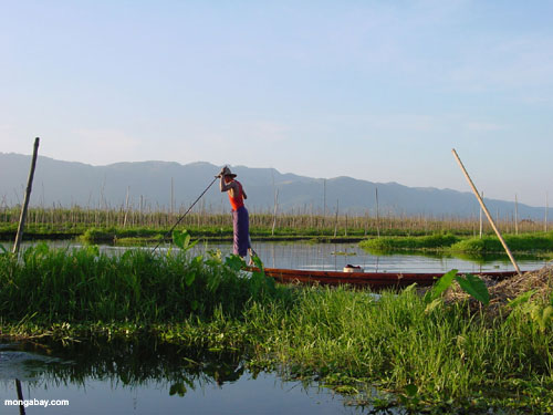
I'm thinking like I am the gardener, producing potatoes and or maize/corn on fields that are almost one mile in width and which go on forever...with channels in between that are some 6 foot wide that carry the water from the delta.
The above image is an example from Myanmar (Burma) and one needs to ask; how would all that produce be transported? By boat? For how many miles? How are the workers delivered? How many miles would they need to walk or row to work?
I would be interested to know to what extent all this is flooded in the rainy season. Anyone have a Google Earth or similar site that would cover that season?
I can't offer any further information, I'm tempted now to write to the author and ask him that very question.
166
posted on
01/05/2015 3:48:17 AM PST
by
Fred Nerks
(Fair Dinkum!)
To: gleeaikin
http://vimeo.com/64351951
this is the vimeo video that started it.
Ancient Irrigation of South Africa
from Gary Schoenung 1 year ago
The Okavango delta in South Africa is surrounded by evidence of hundreds of miles of artificial irrigation. The parallel channels that you see are a mile or so apart. This suggests that there was once an extremely large population there utilizing advanced agricultural techniques. (VIDEO UPDATED September 8 2013)
It’s one of a series of 10:
http://vimeo.com/user12206452/videos
167
posted on
01/05/2015 5:00:56 PM PST
by
Fred Nerks
(Fair Dinkum!)
To: SunkenCiv
Had me going until he hit that part about 5 billion people. Also, 750’ wide agricultural canals?
To: Fred Nerks; WhiskeyX; cripplecreek; SunkenCiv; no-to-illegals; All
After looking at the low angle, 5 minute video of the “irrigation” ditches, I am even more convinced that these are not sand dunes. You simply do not find sand dunes regularly arranged on either side of a narrow feature, then a regular wide feature before the next cluster. Also, the soil colors appear to be similar on each side of the ditches as digging and throwing up embankments would cause. I noticed a number of whitish areas, would those be salt contamination of the soil?
I looked at several of the other videos you posted. I am inclined to think that the “wall” in Wisconsin is natural splitting of rock, he really did not show enough area to clarify conclusions. The Australian “pyramids” were interesting. Unlike the photos of the Egyptian and Mexican pyramids, it was hard to see elevated terrain features. I think a more like source is south Asian settlers, the forms seem more similar. Also there are enough of them to conclude they are not a natural phenomenon. Cheers, and I plan to continue looking at the Okavango situation and hope some serious archaeology gets funded soon for that area.
To: gleeaikin
Anyone who thinks those are man made is a moron and I don’t want them wasting any more of my time.
170
posted on
01/06/2015 4:12:07 AM PST
by
cripplecreek
(You can't half ass conservatism.)
To: colorado tanker
The figures he cites tend toward hyperbole.
171
posted on
01/06/2015 4:44:22 AM PST
by
SunkenCiv
(Imagine an imaginary menagerie manager imagining managing an imaginary menagerie.)
To: gleeaikin
To: SunkenCiv
173
posted on
01/06/2015 5:29:20 AM PST
by
cripplecreek
(You can't half ass conservatism.)
To: cripplecreek
174
posted on
01/06/2015 6:31:28 AM PST
by
SunkenCiv
(Imagine an imaginary menagerie manager imagining managing an imaginary menagerie.)
To: cripplecreek
or ammo bunkers for House Atreides....
To: WhiskeyX; Fred Nerks; SunkenCiv; blam; no-to-illegals; All
I looked at both links. The first one showed a road in some very flat land, with no sign of sand dunes, even relatively low ones. I don’t know if there was some way I was supposed to make a long trip down the road in the various places, but all I managed was to turn around in the other direction. No travel across anything that might have been an excavated area that I could figure out how to make happen. The spooky music was interesting, but not relevant
Do you happen to have any scientific basis for your rejection of the canals idea. I had a year of geology, and we saw a lot of pictures of various kinds of landscape, and nothing with sand dunes created anything that looked like this area. So unless you can show me something specifically scientific that refutes them, I am sticking with my interpretations.
To: gleeaikin
It serves no purpose imo to get hung up about one region out of the probable thousands on the surface of the planet covered by inexplicable lines and symbols, with more and more being uncovered through Google Earth almost daily. Some are obviously misinterpreted, some, like the Nazca Lines are impossible for us to comprehend. Another good example can be found on the Vernuekpan dry lake bed in South Africa.

The place-mark on the top right hand side of the image shows a line that leads to the place-mark in the centre, which ends near the junction of the outline of a V you can barely see in the image I have posted above. This line, possibly a canal, is broken from time to time by what might be sand dunes. 
If you go to Google Earth and explore this region beneath the centre place-mark, you will be as astonished as I was. The phenomenon continues over a much larger region that I have pointed out here, there is much more of a different kind to the right of the V, which do have a similarity to the irrigated fields in South America.
I doubt we will have the answers to everything in our lifetimes...but that shouldn't stop us from looking, and admitting we often don't know how it got there.
177
posted on
01/07/2015 3:00:25 AM PST
by
Fred Nerks
(Fair Dinkum!)
To: gleeaikin
It's there, and one man with a tractor didn't do it.

178
posted on
01/07/2015 3:13:04 AM PST
by
Fred Nerks
(Fair Dinkum!)
To: Fred Nerks
Those are vehicle tracks associated with a variety of modern human activities including using the flats for land speed records by Sir Malcolm Campbell and others, kiting, and more.
To: gleeaikin
“I looked at both links. The first one showed a road in some very flat land, with no sign of sand dunes, even relatively low ones.”
Duh...while you are on the road in the Google Steetview panorama, you’re sitting atop one of the stripes in your pictures that you claim to be human made canals. No canal, imagine that. Yes, the land is very flat, nonetheless you are looking down a road that travels across dunes and the valleys between the dunes. You cannot see the dunes, because, as was said before in prior posts, the dunes have been degraded in the past tens of thousands of years until they have been leveled into relatively flat lands and the valleys between the dunes filled to produce relatively flat lands. The stripes visible in the satellite and aerial views result from the differences in chemistries between the soils of the whitish silicate and calcium carbonate rich degraded linear dunes and the reddish clay filled valleys between the linear dunes. While traveling down the road in the Streetview, you cannot find any canals, because they quite simply do not exist except in the minds of the gullible, who insist upon the existence of UFO alien engineers and like fantasies.
“I don’t know if there was some way I was supposed to make a long trip down the road in the various places, but all I managed was to turn around in the other direction.”
That location was reached by using Streetview to travel on the roads out of the Tsodilo Hills UNESCO World Heritage Site and towards the southeastern and eastern areas beyond them. The Streetview function becomes problematic at about the point of the picture. Using Streetview in the vicinity of the Tsodilo Hills site gives you an opportunity to witness no canals exist where the Google satellite views show the colored stripes on the ground. Instead, Steetview demonstrates how the ancient linear sand dunes and valleys between them were leveled by aeolian forces and erosion to produce soils differing in coloration in a striped pattern.
“No travel across anything that might have been an excavated area that I could figure out how to make happen.”
Streetview can work from that location and along the road/s back to the Tsodilo Hills. When you get your computer and Streetview to work properly to travel down the road, note how your position in the satellite view travels directly across some the same features seen in the Google satellite view you are erroneously claiming to be canals/ditches.
“The spooky music was interesting, but not relevant”
It is relevant because it is mystery music accompanying your fictional mystery canals.
“Do you happen to have any scientific basis for your rejection of the canals idea.”
Why are you pretending to be ignorant of the scientific sources referenced in the previous posts?
“I had a year of geology, and we saw a lot of pictures of various kinds of landscape, and nothing with sand dunes created anything that looked like this area.”
Evidently you failed to benefit from your college education in geology, otherwise you would have immediately understood our prior comments about “degraded” linear sand dunes and their obvious relationship to the formation of sedimentary soils and rocks. Sand dunes, linear and otherwise, which persist long enough to become consolidated and embedded into the soils are in the transition to becoming sandstone and limestone. Degraded sand dunes in sedimentary units was a common feature in our geomorphology surveys.
“So unless you can show me something specifically scientific that refutes them, I am sticking with my interpretations.”
Why do you choose to deny the sources already provided to you in prior posts which reported how cores were taken from the sand dunes?
Navigation: use the links below to view more comments.
first previous 1-20 ... 141-160, 161-180, 181-200, 201-211 next last
Disclaimer:
Opinions posted on Free Republic are those of the individual
posters and do not necessarily represent the opinion of Free Republic or its
management. All materials posted herein are protected by copyright law and the
exemption for fair use of copyrighted works.
FreeRepublic.com is powered by software copyright 2000-2008 John Robinson