Skip to comments.
Prehistoric human migration in Southeast Asia driven by sea-level rise, study reveals [Sundaland]
Phys dot org ^
| February 6, 2023
| Nanyang Technological University
Posted on 02/21/2023 4:20:43 PM PST by SunkenCiv
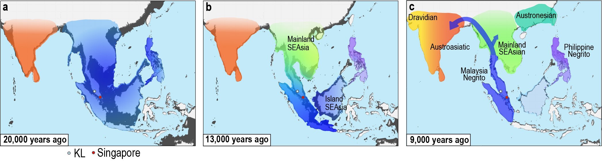
The Malay Peninsula and the islands of Sumatra, Borneo, and Java were originally part of a large landmass of rainforests and coastal mangroves in the South Asia continental shelf known as the Sundaland some 26,000 years ago (see figure a).
But during the last major period of global warming in Earth's history, from the Last Glacial Maximum period (approximately 26,000—20,000 years ago) to the mid-50 Holocene (approximately 6,000 years ago), sea level rose 130 meters. The rise in sea level flooded and submerged half of the Sundaland, breaking land bridges and splitting the large landmass into smaller islands of the region today.
To understand the impact on humans living in the Sundaland during one of the most dramatic sea-level rises in the Earth's history, the team of NTU Singapore scientists reconstructed the history of the landmass using two different approaches: paleogeography—the study of historical physical landscapes—and population genetics...
...the research team constructed paleogeographic maps dating from 26,000 years ago to the present.
The NTU team also used whole-genome sequence data from 59 ethnic groups, including that belonging to populations native to Southeast and South Asia from 50,000 years ago. By analyzing the high-quality genome data, the team was able to infer the genetic ancestry and demographic history of the groups, including their population size and distribution.
While researchers elsewhere have studied population history based on genetics, most of them used mitochondrial DNA (genes inherited from the mother), which does not tell the full picture of individual ancestry.
By using whole-genome sequence data—precise information of an individual's entire genetic makeup inherited from both the mother and the father—the NTU study offers an unbiased demographic history of the indigenous populations inhabiting the Sundaland.
(Excerpt) Read more at phys.org ...
TOPICS: History; Science; Travel
KEYWORDS: ancientnavigation; genealogy; godsgravesglyphs; helixmakemineadouble; noahsmalarkey; sundaland
Figure a: A paleogeographic map of South Asia and The Sundaland in Southeast Asia over 20,000 years ago. These lands were occupied by their respective earliest settlers.Figure b: Rising sea level flooded The Sundaland, reduced the land area and caused land splits into smaller islands, influencing multiple population dispersal and population surge, especially in the Island Southeast Asian region. Figure c: Overpopulation in the Island Southeast Asian region drove the Malaysian Indigenous group (Malaysia Negrito, or commonly known as ‘Orang Asli’) to migrate back northward, toward Mainland Southeast Asia and South Asia.Credit: Communications Biology (2023). DOI: 10.1038/s42003-023-04510-0
1
posted on
02/21/2023 4:20:43 PM PST
by
SunkenCiv
To: StayAt HomeMother; Ernest_at_the_Beach; 1ofmanyfree; 21twelve; 24Karet; 2ndDivisionVet; 31R1O; ...
2
posted on
02/21/2023 4:21:30 PM PST
by
SunkenCiv
(Imagine an imaginary menagerie manager imagining managing an imaginary menagerie.)
To: SunkenCiv
There was sea level rise 20,000 years ago?
Was the global economy based on petroleum then, too?
To: SunkenCiv
Key statement in article: last major period of global warming in Earth's history, from the Last Glacial Maximum period (approximately 26,000—20,000 years ago)
Was it SUV's? Coal burning power plants? Cave man burning twigs?
4
posted on
02/21/2023 4:34:45 PM PST
by
entropy12
(Food is most popular anxiety drug, exercise is the least popular.)
To: SunkenCiv
5
posted on
02/21/2023 4:35:28 PM PST
by
Jim Noble
(You have sat too long for any good you have been doing)
To: SunkenCiv
Everyone must have been driving SUV’s back in those days.
6
posted on
02/21/2023 4:36:30 PM PST
by
wjcsux
(RIP Rush Limbaugh 12 Jan 1951- 17 Feb 2021. We really miss you. 😢)
To: SunkenCiv
The dispersal of the population of Sundaland explains why the genetics of the mountain people in New Guinea and Burma (for example) are more similar to each other than to the coastal people in the same countries.
When the ocean rose 400 feet (average depth of the Sunda Sea is 150 feet), the people dwelling on the plains and in the farmlands sought the highest ground they could find (wouldn’t you?).
Some went North, some went South.
7
posted on
02/21/2023 4:43:30 PM PST
by
Jim Noble
(You have sat too long for any good you have been doing)
To: SunkenCiv

Driving smog-producing cars. Overconsumption of beef. No wonder why there was Global Warming in prehistoric times!!
8
posted on
02/21/2023 4:49:53 PM PST
by
Opinionated Blowhard
(When the people find that they can vote themselves money, that will herald the end of the republic.)
To: SunkenCiv
Sundaland, isn’t that across The Tyne from Newcastle?
9
posted on
02/21/2023 4:50:41 PM PST
by
dfwgator
(Endut! Hoch Hech!)
To: SunkenCiv
And I can create a study which shows they migrated directly across my property if I wish to tilt the outcome of the study to my chosen narrative.
How many things have the “experts” told us over the past decades (and last few years) that have later found out to be based on false data?
10
posted on
02/21/2023 4:52:50 PM PST
by
CFW
(old and retired)
To: CFW
You could, but that wouldn’t be based on data.
11
posted on
02/21/2023 5:00:19 PM PST
by
SunkenCiv
(Imagine an imaginary menagerie manager imagining managing an imaginary menagerie.)
To: SunkenCiv
Several years ago I went on a geology binge.
Learned the British Isle were connected to Europe, Japan connected to Asia, Eurasia connected to N. American (this how 3 different groups of Native Americans came here).
That the Sahara Desert had river beds and at one point the Mediterranean Sea had pretty much dried up.
Fossils of ferns showed they were several feet tall cuz CO2 was through the roof. (Uhhh. Making the planet MORE green.}
Geology dismisses the man-made global climate change crap.
A few years ago a prehistoric shark fossil was found in the Peruvian desert.
When I was a kid in the early 70’s heard “The Ice Age is coming and the world gonna end in 10 years.
“Climate change” isn’t about science. It’s about control.
This seem to start about the same time the WEF started to formed. Coincidents??
12
posted on
02/21/2023 5:10:56 PM PST
by
lizma2
To: SunkenCiv
“You could, but that wouldn’t be based on data.”
Sure it would. My “study” would show the data that I based my study upon, and it would be believable. We have seen it before in several studies that were later shown to be based upon falsified data.
13
posted on
02/21/2023 5:12:28 PM PST
by
CFW
(old and retired)
To: entropy12
Eden in the East by Barry Oppenheimer. 1998.
14
posted on
02/21/2023 5:42:35 PM PST
by
arthurus
(covfefe .|.)
To: Four of Six
Was the global economy based on petroleum then, too?Not known to most they were driving SUVs powered by coal and petroleum and natural gas. Thus the ice caps melted.
In the words of Joe Isuzu, "would I lie to you." LOL
15
posted on
02/21/2023 9:57:37 PM PST
by
cpdiii
(cane cutter-deckhand-roughneck-oil field trash- drilling fluid tech-geologist-pilot- pharmacist)
To: SunkenCiv
As you know....a favored subject of mine:
Sundaland
16
posted on
02/22/2023 5:49:59 AM PST
by
blam
To: Jim Noble
That was an excellent book.
17
posted on
02/22/2023 5:52:30 AM PST
by
blam
To: SunkenCiv
The sea level rose without any manufacturing or western culture...amazing.
To: blam
I knew you’d like it. :^)
19
posted on
02/22/2023 11:40:55 AM PST
by
SunkenCiv
(Imagine an imaginary menagerie manager imagining managing an imaginary menagerie.)
Disclaimer:
Opinions posted on Free Republic are those of the individual
posters and do not necessarily represent the opinion of Free Republic or its
management. All materials posted herein are protected by copyright law and the
exemption for fair use of copyrighted works.
FreeRepublic.com is powered by software copyright 2000-2008 John Robinson
