
Posted on 05/06/2022 11:38:01 AM PDT by Red Badger
Island Found Eastern Coast of Antarctica Annotated Unnamed island off the Glenzer and Conger ice shelves in East Antarctica. November 15, 1989 – January 9, 2022
An unnamed mound of white off East Antarctica seems to be an island.
The eastern coast of Antarctica has lost the majority of the Glenzer and Conger ice shelves. In the process, it gained what is likely an island. If confirmed, the unnamed island would be one in a series of islands exposed in recent years as portions of the floating glacial ice hugging the continent’s coast have disintegrated.
The candidate island is visible in the above triptych of images acquired by Landsat satellites between 1989 and 2022. The images are a combination of shortwave infrared and visible light, and were adjusted for consistency in brightness and color. Notice how the island has maintained the same shape, even after shelf ice detached from it, and as sea ice around it waxed and waned. That round white mound has not budged, even after large icebergs likely smashed into it following the rapid collapse of the Glenzer and Conger ice shelves earlier this year.
The feature also appears taller than its surroundings. The elevation profile below indicates that at least part of the mass stands 30 to 35 meters (100 to 115 feet) above the surface of the sea. The data were acquired on December 22, 2021, with the Advanced Topographic Laser Altimeter System (ATLAS) on NASA’s Ice, Cloud, and land Elevation Satellite 2 (ICESat-2).
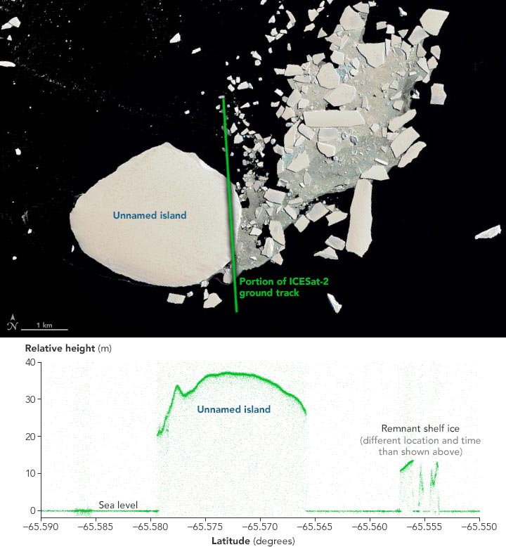
Unnamed Island Eastern Coast of Antarctica
December 22, 2021 – January 9, 2022
But just because a feature acts like an island and looks like an island, does not mean it is an island—at least not in the traditional sense. Scientists are still unsure if there is any solid earth breaching the sea surface below all of the snow and ice.
John Gibson, a scientist with the Australian Antarctic Division, thinks the feature is likely an ice island: a large, heavy cap of ice sitting solidly on an underwater peak. “It is undoubtedly similar to other ice islands, such as Bowman Island,” Gibson said.
Gibson called the ice island “self-perpetuating,” meaning that snow and ice accumulating on the island’s surface balances out the amount of melting that occurs underwater. If that balance becomes disrupted by a decrease in snowfall, then the ice island could thin and float away. “The unnamed island is a more-or-less permanent feature of the landscape,” Gibson said, “but may someday detach from the underlying rock and become an iceberg.”
Without anyone having been there to observe the island, questions remain about its structure. “To be absolutely sure, you would need to put a ship next to it to check for a bedrock outcrop, and maybe a radar over it to assess the ice thickness,” said Christopher Shuman, a University of Maryland, Baltimore County, glaciologist based at NASA’s Goddard Space Flight Center. “The ICESat-2 profile shows that the surface is well above sea level. That would be a whole lot of ‘ice cream’ above the ‘cone’ if there wasn’t bedrock at or above sea level.”
Traditional or ice, the island is the latest in a bunch of similar features that are no longer embedded in Antarctica’s floating glacial ice. In 2019, the U.S. Board on Geographic Names recognized Icebreaker Island, which in 1996 became isolated from the Larsen B Ice Shelf along the Antarctic Peninsula. And in 2020, researchers on a ship-based expedition discovered a small, rocky island capped with ice that may have been part of Pine Island Glacier’s ice shelf.
“The discovery of more of them is likely to continue in the years ahead due to shrinking glacial and sea ice,” Shuman said. “Obviously these are ‘new to us’ features, but we also have more people and more tools to look at the margins of Antarctica now. Several examples do not make a trend, but they do imply that other once-hidden features are likely to be noticed in the years to come.”
NASA Earth Observatory images by Joshua Stevens, using Landsat data from the U.S. Geological Survey, and ICESat-2 data from the National Snow & Ice Center. Story by Kathryn Hansen, with information from Christopher Shuman (NASA GSFC/UMBC JCET).
I suggest we call it CTHULHU ISLAND!..............
So that’s where I left it.
Falling sea levels.
Maybe the lefties threatening to leave America..again..could move there and start their utopia?
Since Trump is responsible for exposing the island it should be named after him. /sarcasm
I’m confused on basic geography. I am of the opinion that EVERY part of the coast of Antarctica is the northern coast. Am I wrong?
Only if you are standing exactly on the south pole. then everything is north.
but for simplicity sake, you are correct, everything is north
Land. Who says they are not making it anymore?
Hey, just found my summer, err, winter resort!
Wait, a new island? Shouldn't it be flooded because the sea Rose when the ice melted??🤓
Tectonic force raised the island
Thanks Red Badger.
By Libya, Herodotus and/or the translator means the continent of Africa. A bit omitted from this -- these voyagers ran into "shoals", which were apparently the calved icebergs drifting off from Antarctica, or at least, IMHO.The HistoriesAs for Libya, we know it to be washed on all sides by the sea, except where it is attached to Asia. This discovery was first made by Necos, the Egyptian king, who on desisting from the canal which he had begun between the Nile and the Arabian gulf, sent to sea a number of ships manned by Phoenicians, with orders to make for the Pillars of Hercules, and return to Egypt through them, and by the Mediterranean. The Phoenicians took their departure from Egypt by way of the Erythraean sea, and so sailed into the southern ocean. When autumn came, they went ashore, wherever they might happen to be, and having sown a tract of land with corn, waited until the grain was fit to cut. Having reaped it, they again set sail; and thus it came to pass that two whole years went by, and it was not till the third year that they doubled the Pillars of Hercules, and made good their voyage home. On their return, they declared -- I for my part do not believe them, but perhaps others may -- that in sailing round Libya they had the sun upon their right hand. In this way was the extent of Libya first discovered.
by Herodotus
tr by George Rawlinson
Book IV -- Melpomene
This makes sense to me.
Disclaimer: Opinions posted on Free Republic are those of the individual posters and do not necessarily represent the opinion of Free Republic or its management. All materials posted herein are protected by copyright law and the exemption for fair use of copyrighted works.
