Posted on 06/21/2016 9:53:56 AM PDT by Red Badger
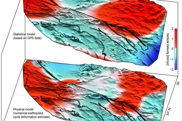
The top diagram shows the lobes of movement, uplift in red and subsidence in blue, found using GPS data, while the botom diagram shows the lobes predicted by an earthquake simulation model. Image by University of Hawaii, Manoa ===============================================================================================
HONOLULU, June 20 (UPI) -- Analysis of GPS data has revealed new areas of motion around the San Andreas Fault System.
Using data collected by the EarthScope Plate Boundary Observatory's GPS array, researchers identified 125-mile-wide "lobes" of uplift and subsidence. Over the last several years, the lobes, which straddle the fault line, have hosted a few millimeters of annual movement.
Computer models simulating the San Andreas Fault System have predicted such crustal movement, but the areas of motion hadn't been physically identified until now.
Researchers used advanced statistical modeling to identify the movement among the inevitable statistical noise that comes with monitoring minute movements in the Earth's crust.
"While the San Andreas GPS data has been publicly available for more than a decade, the vertical component of the measurements had largely been ignored in tectonic investigations because of difficulties in interpreting the noisy data," lead author Samuel Howell, a researcher at the University of Hawaii at Manoa, explained in a news release. "Using this technique, we were able to break down the noisy signals to isolate a simple vertical motion pattern that curiously straddled the San Andreas fault."
The validity of the vertical patterns was confirmed by the fact that similar motions were predicted by an earthquake model designed by researchers at the University of Hawaii's School of Ocean and Earth Science and Technology.
"We were surprised and thrilled when this statistical method produced a coherent velocity field similar to the one predicted by our physical earthquake cycle models," said researcher Bridget Smith-Konter. "The powerful combination of a priori model predictions and a unique analysis of vertical GPS data led us to confirm that the buildup of century-long earthquake cycle forces within the crust are a dominant source of the observed vertical motion signal."
Researchers say their new findings -- published in the journal Nature Geosciences -- could help scientists use smaller lobes of vertical motion to predict more significant ruptures.
SoCal ping
Yes, raising taxes and electing Hillary. She will know how to spend all that money to keep you safe!
I am so screwed.
One day soon they’ll all be surfin’ off the Arizona coast.
Then you’ll at least die happy......................
I was including those as well. Massive amounts of weight redistribution like a tire out of balance....................
Or moves laterally several feet. It has happened before........................
Which will make all of America a soft target for muzzie terrorism.
ROFLMAO


Please ping me with any Southern California related articles. Thank you!
If you want on or off this ping list, please FReepmail me.
I know you’re being facetious but I did a quick look-up anyway.
The total weight of human civilization including all people and all things built by people (97% of which is concrete and steel):
125 billion tons
Total weight of planet earth:
6 trillion billion tons
The earth is 48 billion times heavier than the total weight of human civilization.
Question to anyone who may want to answer this. Should the movement of the fault line cause some serious disturbance is there a chance that it may affect Yellowstone. I hope note, as if Yellowstone should become airborne it could affect a good portion of the US.
Yeah, my money’s on Yellowstone. I don’t believe the ‘magma five miles below’ story for a minute. Not when forests are dying from the heat, roads are melting and many areas are now off limits.
The constant uplift and subsidence in different areas of the park indicates magma much closer to the surface. The magma rises up, contacts solid rock pushing it up. As the rock melts it adds volume to the magma chamber reducing the upward pressure on the rock. The result is the ground subsides until the magma fills in the space added by the melted rock to start the uplift again.
IMO the magma is much closer to the surface than they’re admitting.
Subduction leads to Orogeny!
Disclaimer: Opinions posted on Free Republic are those of the individual posters and do not necessarily represent the opinion of Free Republic or its management. All materials posted herein are protected by copyright law and the exemption for fair use of copyrighted works.