Posted on 06/21/2016 9:53:56 AM PDT by Red Badger
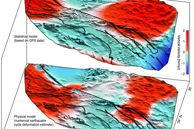
The top diagram shows the lobes of movement, uplift in red and subsidence in blue, found using GPS data, while the botom diagram shows the lobes predicted by an earthquake simulation model. Image by University of Hawaii, Manoa ===============================================================================================
HONOLULU, June 20 (UPI) -- Analysis of GPS data has revealed new areas of motion around the San Andreas Fault System.
Using data collected by the EarthScope Plate Boundary Observatory's GPS array, researchers identified 125-mile-wide "lobes" of uplift and subsidence. Over the last several years, the lobes, which straddle the fault line, have hosted a few millimeters of annual movement.
Computer models simulating the San Andreas Fault System have predicted such crustal movement, but the areas of motion hadn't been physically identified until now.
Researchers used advanced statistical modeling to identify the movement among the inevitable statistical noise that comes with monitoring minute movements in the Earth's crust.
"While the San Andreas GPS data has been publicly available for more than a decade, the vertical component of the measurements had largely been ignored in tectonic investigations because of difficulties in interpreting the noisy data," lead author Samuel Howell, a researcher at the University of Hawaii at Manoa, explained in a news release. "Using this technique, we were able to break down the noisy signals to isolate a simple vertical motion pattern that curiously straddled the San Andreas fault."
The validity of the vertical patterns was confirmed by the fact that similar motions were predicted by an earthquake model designed by researchers at the University of Hawaii's School of Ocean and Earth Science and Technology.
"We were surprised and thrilled when this statistical method produced a coherent velocity field similar to the one predicted by our physical earthquake cycle models," said researcher Bridget Smith-Konter. "The powerful combination of a priori model predictions and a unique analysis of vertical GPS data led us to confirm that the buildup of century-long earthquake cycle forces within the crust are a dominant source of the observed vertical motion signal."
Researchers say their new findings -- published in the journal Nature Geosciences -- could help scientists use smaller lobes of vertical motion to predict more significant ruptures.
I saw this movie. Right after they figured out their predictive models were working massive earthquakes happened all over the movie set.
We’Re DooMed I tellya.. DOOMED!!!

Raise taxes. It’s the only solution.
Interesting. Thanks for posting.
“...a few millimeters of annual movement”
That’s nearly 1/8” ! OMG!
BTW, gays have a much greater risk of dying from STDs. Just saying.
.......and ban guns.......................
Especially in the Juan de Fuca Subduction Zone......................
aha!.....so, the elites are planning to trigger THE BIG ONE just before the election so that Obama can declare MARSHALL LAW, cancel the election and name himself DICTATOR FOR LIFE.
Very clever!
Get out now!
While there’s still somewhere left to go!.......................
Martial.........................
I don’t think our military would allow that.........................
When the JDF goes all hell is going to break loose in the NW. The only question for Seattle is whether it sinks into the sea, is flattened by the Tsunami or raises up out of the sea and is flattened by the earthquake (or a combination of all three). The other question is whether the earthquake awakens Ranier, Hood, Shasta, Lassen or St. Helens.
Absolutely. All those guns are destabilizing the global plate tectonics. Not to mention all those extra clips. Way too many clips. It’s all adding up to a geological catastrophe.
Well, thanks for ruining MY day! Many predictions that when JdF goes, it could very well be the biggest earthquake in recorded history, since it is a subduction fault. Unlike faults like San Andreas, which are slip/slide, this means that it will literally have to lift up a mountain range (the Olympic Peninsula in WA) and probably an island (Vancouver Island) a centimeter or so when it pops. That’s heavy lifting and a whole lot of shakin going on!
I’ve often wondered what effect does world trade have on earthquakes.
Millions and billions of tons of goods are shipped across oceans and continents from points all over the globe. Surely that must have some destabilizing effect on the rotational and centrifugal forces that affect us all..................
What I observed from the actual measurement chart is uplift and no movement.
the boundary between the two is for a long distance the fault line.
The question becomes what is happening along the boundary, the fault line. Is the uplift slipping upward on the fault line or is it stuck?
If slipping there may be no perception. If stuck, when the stress builds up beyond the friction, then there will be shaking and perhaps a massive jolt as the south side breaks loose and quickly rises.
Bert is not a geoscientist and doesn’t teach at a university. he merely observes data and issues a finding
The finished goods do not weigh much in relation to the raw materials. Exporting iron ore, barrels of oil etc amounts to millions of tons.
Disclaimer: Opinions posted on Free Republic are those of the individual posters and do not necessarily represent the opinion of Free Republic or its management. All materials posted herein are protected by copyright law and the exemption for fair use of copyrighted works.