Please limit graphics to ~50KB, and do not post animated graphics.
Godspeed to all in Hurricane Ike's path.
Navigation: use the links below to view more comments.
first previous 1-20, 21-40, 41-42 next last
To: NautiNurse
Thanks for the thread, NN, and prayers for safety for all concerned.
88 posted on
09/10/2008 4:05:10 PM PDT by
Molly Pitcher
(We are Americans...the sons and daughters of liberty...*.from FReeper the Real fifi*))
To: NautiNurse
Its been raining the last two days over most of central and east TX and the ground is pretty wet. I suspect we are going to see unprecedented flooding with this storm. Please pray that it doesn’t stall over the state.
90 posted on
09/10/2008 4:12:20 PM PDT by
Nachoman
(My guns and my ammo, they comfort me.)
To: wolfcreek
Two of my 3 sons live in Austin. I’m sure they’ll be fine, but they’re gonna get wet!
susie
92 posted on
09/10/2008 4:15:01 PM PDT by
brytlea
(Obama--Keep the change!)
To: NautiNurse
track shifting north, this one is gonna be close, Houston we have a probelm.
204 posted on
09/10/2008 7:28:17 PM PDT by
jpsb
To: NautiNurse
I’m halfway between downtown Houston and Galveston, and thinking this gives me a good excuse to go visit friends up in Dallas.
I’m in an apartment, though, any suggestions on what I can do to prepare? It’s looking like the complex isn’t boarding up, so I’m moving everything away from windows, of course, but I’m mainly worried about a tree nailing my windows.
I’m fortunate to have a place to go to. I’ll keep everyone in my prayers, and I hope you’ll do the same for us here.
To: NautiNurse; potlatch; devolve; STARWISE; ntnychik; dixiechick2000; PhilDragoo; y'all
PL, I couldn't reply on the other thread cuz it's locked now. Yep. It looks like it's heading right for you in Victoria.
And right for us here in the Dallas/Ft. Worth area by Saturday.

Better batton down the hatches down there!!
343 posted on
09/10/2008 9:57:05 PM PDT by
MeekOneGOP
(Obama, WHO is Bill Ayers and WHY are you still friends with him? Please RSVP asap!)
To: NautiNurse
I live in NW Houston, and this storm is starting to worry me. We went thru Alicia in 1983, and it was not plesant, even though we were not without power as long as many. (I remember some were without power for 2 weeks or more.) Our house mostly just had some minor shingle damage.
355 posted on
09/10/2008 11:30:15 PM PDT by
smokingfrog
(He that lives upon hope will die fasting. - Ben Franklin)
To: NautiNurse
This
BUOY is fairly close to the path of the hurricane. Showing wave heights of 20 ft. but the wind is not too bad.
357 posted on
09/11/2008 12:16:51 AM PDT by
smokingfrog
(He that lives upon hope will die fasting. - Ben Franklin)
To: NautiNurse
The projected track appears to be shifting clockwise.
368 posted on
09/11/2008 3:38:14 AM PDT by
Clive
Ike hasn't hit the beach with this much force since the day my stepdad graduated from HS IYKWIM.
Seriously, my prayers go out to those in Ike's path. Stay safe, y'all.
ff
To: NautiNurse
414 posted on
09/11/2008 6:24:11 AM PDT by
smokingfrog
(He that lives upon hope will die fasting. - Ben Franklin)
To: NautiNurse
If the current path holds..this will be a total disaster!!!
According to another forum people aren’t taking the storm seriously in the houston area...and local officials and local media are not playing it up....
In fact the mayor of Galveston: “We do not intend to evacuate Galveston Island,” Mayor Lyda Ann Thomas defended this decision, saying current models call for Galveston to be hit with winds and rain only equivalent to a Category 1 hurricane
SHE is 100% wrong!!! and Ike’s storm sruge will swamp the island
To: NautiNurse; All
Jeff Masters - "Category 2 Ike is larger and more powerful than Katrina"
Hurricane Ike's winds remain at Category 2 strength, but Ike is a freak storm with extreme destructive storm surge potential. Ike's pressure fell rapidly last night to 944 mb, but the hurricane did not respond to the pressure change by increasing its maximum winds in the eyewall. Instead, Ike responded by increasing the velocity of its winds away from the eyewall, over a huge stretch of the Gulf of Mexico. Another very unusual feature of Ike is the fact that the surface winds are much slower than the winds being measured aloft by the Hurricane Hunters. Winds at the surface may only be at Category 1 strength, even though Ike has a central pressure characteristic of a Category 3 or 4 storm. This very unusual structure makes forecasting the future intensity of Ike nearly impossible. The possibilities range from a Category 1 storm at landfall--as predicted by the HWRF model--to a Category 4 storm at landfall, as predicted by the GFDL.
Ike is now larger than Katrina was, both in its radius of tropical storm force winds--275 miles--and in it radius of hurricane force winds--115 miles. For comparison, Katrina's tropical storm and hurricane force winds extended out 230 and 105 miles, respectively. Ike's huge wind field has put an extraordinarily large volume of ocean water in motion. When this swirling column of water hits the shallow waters of the Continental Shelf, it will be be forced up into a large storm surge which will probably rival the massive storm surge of Hurricane Carla of 1961. Carla was a Category 4 hurricane with 145 mph winds at landfall, and drove a 10 foot or higher storm surge to a 180-mile stretch of Texas coast. A maximum storm surge of 22 feet was recorded at Port Lavaca, Texas. Despite the fact that the center of Carla hit over 120 miles southwest of Houston, the hurricane drove a 15-foot storm surge into the bays along the south side of the city. I don't expect Ike will reach Category 4 strength, thus its maximum surge is not likely to reach the extreme values above 20 feet seen in Hurricane Carla. Like Carla, though, Ike will probably inundate a 180-mile stretch of Texas coast from Port O'Connor to just north of Galveston with a 10-15 foot storm surge. This will occur even if Ike is a Category 1 storm at landfall. The latest experimental storm surge forecast From NOAA's SLOSH model (Figure 1) shows a 10% chance that Ike's storm surge will exceed 15-21 feet at Galveston. The Galveston sea wall is 17 feet high, so may get overtopped.
The amount of water Ike has put in motion is about 50% greater than what Katrina did, and thus we can expect Ike's storm surge damage will be similar to or greater than Katrina's. The way we can estimate this damage potential is to compute the total energy of Ike's surface winds (kinetic energy). To do this, we must look at how strong the winds are, and factor in the areal coverage of these winds. Thus, we compute the Integrated Kinetic Energy (IKE) by squaring the velocity of the wind and summing over all regions of the hurricane with tropical storm force winds or higher. This "Integrated Kinetic Energy" was recently proposed by Dr. Mark Powell of NOAA's Hurricane Research Division as a better measure of the destructive power of a hurricane's storm surge than the usual Category 1-5 Saffir-Simpson scale. For example, Hurricane Katrina hit Mississippi as a strong Category 3 hurricane, yet its storm surge was more characteristic of a Category 5 storm. Dr. Powell came up with a new scale to rate potential storm surge damage based on IKE (not to be confused with Hurricane Ike!) The new scale ranges from 1-6. Katrina and Wilma at their peaks both earned a 5.1 on this scale (Figure 2). At 9:30am EDT this morning, Ike earned a 5.6 on this scale, the highest kinetic energy of any Atlantic storm in the past 40 years.
Galveston's seawall has never been topped.
To: NautiNurse
Gov Perry just said the storm has changed direction to east rather than west.
532 posted on
09/11/2008 9:46:43 AM PDT by
freekitty
(Give me back my conservative vote.)
To: NautiNurse
NN: Just want to thank you again for all of these threads. You are just awesome and a special place in heaven for you.
To all of you in the path of this storm....good luck, stay safe, and Pray.
Leaving the 77571 zip code in an hour or so.
Last one leaving the coastal areas turn out the lights...
539 posted on
09/11/2008 9:55:56 AM PDT by
Katlyn
To: NautiNurse
I’m getting a bad feeling about Ike. Because the forecasters couldn’t get a fix on its track and strength, I think a lot of people will have waited too long to make preps or evacuate. Dallas is only getting a trickle of critical-care evacuees right now. I fear many will be trapped on the highway during a last-minute bug out.
643 posted on
09/11/2008 1:43:44 PM PDT by
Nachoman
(East of Dallas.)
To: NautiNurse; SouthTexas
666 posted on
09/11/2008 2:28:16 PM PDT by
flattorney
(See my comprehensive FR Profile "Straight Talk" Page)
To: NautiNurse
I saw on the news a little while ago that it's deadheading right at Houston.
I'm praying for a miracle...that it somehow breaks up or lessens in strength.
This doesn't look good at all. I won't relax until I've heard from every one of my loved ones back home after this thing is over.
667 posted on
09/11/2008 2:28:28 PM PDT by
Allegra
(Prayers up for all in Ike's path. Please be safe...my hometown.)
To: NautiNurse
Latest Tracks Projections
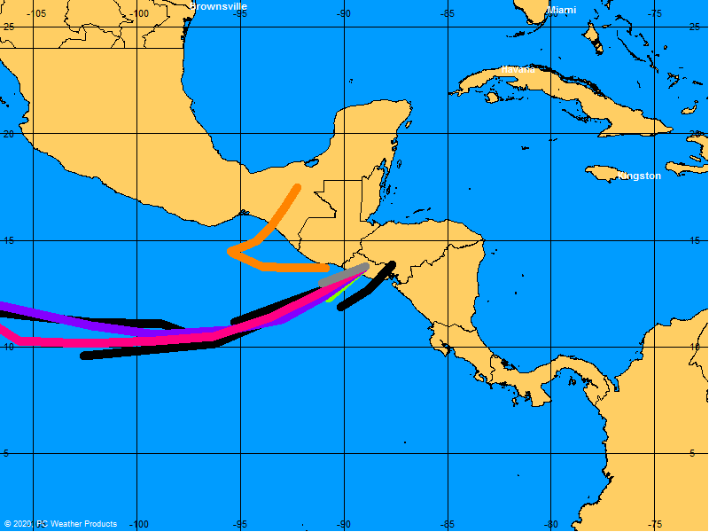
684 posted on
09/11/2008 2:45:44 PM PDT by
flattorney
(See my comprehensive FR Profile "Straight Talk" Page)
To: Conservababe
792 posted on
09/11/2008 6:48:34 PM PDT by
Cyber Liberty
(Pretending that the Admin Moderator doesn't exist will result in a suspension.)
Navigation: use the links below to view more comments.
first previous 1-20, 21-40, 41-42 next last
FreeRepublic.com is powered by software copyright 2000-2008 John Robinson