Skip to comments.
Two feet of snow possible in parts of northeast U.S., mid-Atlantic states Sunday to Tuesday (Jan 31st to Feb 2nd)
original to Free Republic
| Jan 30 2021
| Peter O'Donnell
Posted on 01/30/2021 5:23:29 PM PST by Peter ODonnell
You probably heard that a snowstorm is approaching the major cities of the northeastern U.S. and the mid-Atlantic states.
Some forecasting models have outcomes as high as 24-36 inches of snow for some areas. Most at risk appears to be eastern PA, NJ, and MD. NYC and LI could also get hit with 18-24 inch amounts.
So far it looks a bit less extreme for most of New England, with forecast models saying 6-12 inches for most areas. That is also the case for western PA, central NY state, and some parts of the Midwest where the storm has already started.
Low pressure moving through Missouri at present time will track into Kentucky by Sunday. At that time, a coastal low will form off North Carolina, capture most of the energy of the inland storm, and produce heavy snowfall near the I-95 corridor. Strong east winds will develop near the coast, and inland the snow may blow around at times with near-blizzard conditions.
If you've heard a forecast for 6-12 inches, that may in fact verify but be aware that there are significant chances of a much heavier total snowfall especially around Baltimore to Philadelphia to NYC.
This thread can now be used for actual storm observations as we go forward. The east coast snowfall will begin Sunday afternoon. It will start soon in Ohio and w PA.
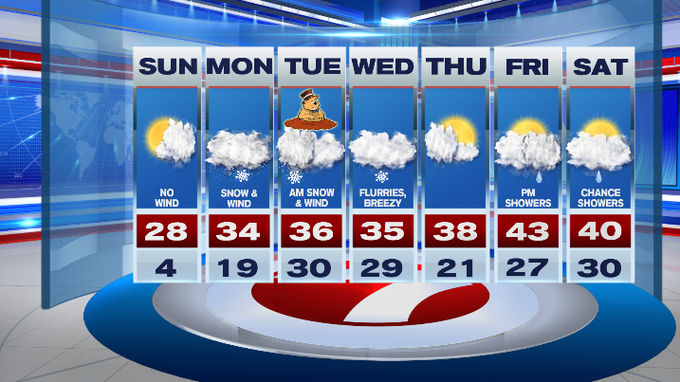
Temperatures with the snowfall are around 28-30 F, and a mixing zone is likely in parts of Delaware, southeast MD and southeast VA (sleet, ice etc). Heavy rain is the most likely outcome for Norfolk VA and that region. But the storm could transition to wet snow near the final portions on Tuesday.
Would advise some to stock up today before it gets messy as this may be a long-duration storm with a slow recovery period Tues-Wed. Could be Thursday before you'd want to go out again once the storm begins.
TOPICS: Front Page News
KEYWORDS: globalwarming; iceage; letitsnow; milkandbread; storm
Navigation: use the links below to view more comments.
first previous 1-20 ... 41-60, 61-80, 81-100 ... 121-140 next last
To: Peter ODonnell; cgbg; fieldmarshaldj; Impy
It’s no longer expected to skim along the coast
Inland snow. Direct hit in Hartford County, Tolland, maybe Litchfield
Digging out on Tuesday
61
posted on
01/31/2021 4:21:05 PM PST
by
campaignPete R-CT
(Committee to Re-Elect the President ( CREEP ) )
To: Peter ODonnell
Maybe DC will be snowed in for a few weeks.
62
posted on
01/31/2021 4:29:21 PM PST
by
Chgogal
(Hey Biden, I am a loyal supporter of the Biden's Banana Republic!)
To: metmom
Nor’easters are notoriously difficult to forecast Coastal New England has been notoriously difficult to forecast, much due to that large pond to the East, and in April-May some real dynamics can sometimes be seen. You'll are looking at about up to 20''.
 https://www.nbcboston.com/news/local/timeline-track-the-3-day-winter-storm-approaching-new-england/2289478/
63
posted on
01/31/2021 5:37:39 PM PST
by
daniel1212
(Turn to the Lord Jesus as a damned + destitute sinner + trust Him to save + be baptized+follow Him!)
To: daniel1212
We’re looking at not quite a foot. My son, closer to the coast, is looking at a foot and a half.
64
posted on
01/31/2021 5:40:19 PM PST
by
metmom
(...fixing our eyes on Jesus, the Author and Perfecter of our faith.....)
To: Jamestown1630
In ‘91 I worked in DC, Anacostia in fact. A big storm rolled in and I made a run for it. The Beltway was guaranteed to be a nightmare so I bailed onto the road through Rock Creek Park. Nobody was there. Nice fresh snow and decent traction the whole way, then surface streets through neighborhoods back into Monkey County.
To: All
Latest guidance indicating heaviest snow e PA, NJ, NYC, LI and parts of s New England. 20-40 inch potential (the 40 in most likely to occur 50-100 miles north of PHL).
66
posted on
01/31/2021 6:08:43 PM PST
by
Peter ODonnell
(Pray for health, economic recovery, and justice.)
To: metmom
We’re looking at not quite a foot. My son, closer to the coast, is looking at a foot and a half. Strange. Around Boston the closer to the coast then the less snow. Unless your coast juts out.
67
posted on
01/31/2021 6:15:21 PM PST
by
daniel1212
(Turn to the Lord Jesus as a damned + destitute sinner + trust Him to save + be baptized+follow Him!)
To: daniel1212
It peaks a little bit inland, but I think even with less snowfall, the winds are going to be an issue.
68
posted on
01/31/2021 6:20:43 PM PST
by
metmom
(...fixing our eyes on Jesus, the Author and Perfecter of our faith.....)
To: daniel1212
A couple more factors to consider.
Temperature plays a role in snowfall totals, and right on the coast it’s generally warmer.
That would either reduce the snowfall totals by mixing in with rain or icing.
And if the snow is wetter, it’s going to be more dense and compact more. So the actual precipitation totals might be the same but the snowfall amounts will vary because light fluffy snow is going to give more measured inches than heavy wet slop.
69
posted on
01/31/2021 6:25:09 PM PST
by
metmom
(...fixing our eyes on Jesus, the Author and Perfecter of our faith.....)
To: Tijeras_Slim
Many years ago, I drove the Beach Drive several times a week.
When it was really rainy, it was scary - sometimes ‘fountains’ would spout up from the grass, off-side from the creek; and I once lost my brakes going through a really big puddle...
I’m glad I haven’t had to do that in many years.
70
posted on
01/31/2021 7:15:07 PM PST
by
Jamestown1630
("Corn Pop was a bad dude. He ran a bunch of bad boys.")
To: Jamestown1630
I figured out a ton of ways to avoid the major roads, that one was a favorite.
Snow isn’t a issue now, I’m at 7300’ in the New Mexico mountains and a foot or less we just drive through.
My Mom is on the Eastern Shore, so she might get buried by this one, but has plenty of food, and a neighbor with a tractor with a blade.
To: Tijeras_Slim
The Shore will probably just get rain out of this.
72
posted on
01/31/2021 7:49:55 PM PST
by
Jamestown1630
("Corn Pop was a bad dude. He ran a bunch of bad boys.")
To: metmom
Temperature plays a role in snowfall totals, and right on the coast it’s generally warmer. Indeed, and harder to shovel, but quicker to melt. Later this week.
 © Copyright 2000 - 2021 WHDH-TV.
And they are reducing the estimates near the coast.
73
posted on
01/31/2021 8:58:35 PM PST
by
daniel1212
(Turn to the Lord Jesus as a damned + destitute sinner + trust Him to save + be baptized+follow Him!)
To: campaignPete R-CT; GOPsterinMA; BillyBoy
We haven’t had this much snow in Chi in at least 3 years.
74
posted on
01/31/2021 10:19:40 PM PST
by
Impy
(George Washington did not concede to King George.)
To: Impy
How much is ‘this much’, so far?
75
posted on
01/31/2021 10:22:00 PM PST
by
Jane Long
(America, Bless God....blessed be the Nation 🙏🏻🇺🇸)
To: Jane Long
76
posted on
02/01/2021 12:07:00 AM PST
by
Impy
(George Washington did not concede to King George.)
To: Impy; NFHale; BillyBoy; fieldmarshaldj
77
posted on
02/01/2021 5:25:03 AM PST
by
GOPsterinMA
(I'm with Steve McQueen: I live my life for myself and answer to nobody.)
To: Impy
The last thing we need is snow in the Windy City.
It’s miserable enough there
78
posted on
02/01/2021 8:10:13 AM PST
by
campaignPete R-CT
(Committee to Re-Elect the President ( CREEP ) )
To: Jamestown1630
Meteorologists can explain very well—what happened after it happens.
79
posted on
02/01/2021 8:22:03 AM PST
by
Exit148
To: daniel1212; cgbg; metmom; Peter ODonnell; Impy
 As of 11 a.m. a shift to the west. This is now on Front Page News

80
posted on
02/01/2021 9:12:35 AM PST
by
campaignPete R-CT
(Committee to Re-Elect the President ( CREEP ) )
Navigation: use the links below to view more comments.
first previous 1-20 ... 41-60, 61-80, 81-100 ... 121-140 next last
Disclaimer:
Opinions posted on Free Republic are those of the individual
posters and do not necessarily represent the opinion of Free Republic or its
management. All materials posted herein are protected by copyright law and the
exemption for fair use of copyrighted works.
FreeRepublic.com is powered by software copyright 2000-2008 John Robinson
 https://www.nbcboston.com/news/local/timeline-track-the-3-day-winter-storm-approaching-new-england/2289478/
 © Copyright 2000 - 2021 WHDH-TV.
  As of 11 a.m. a shift to the west. This is now on Front Page News