Posted on 12/03/2018 7:50:00 AM PST by fishtank
Grand Canyon Carved by Flood Runoff
BY TIM CLAREY, PH.D. * | FRIDAY, NOVEMBER 30, 2018
Secular science has long struggled to explain the timing and origin of Grand Canyon. The majority of secular scientists assumes it was carved by a large river in less than six million years.1 Why did it form where it did? In particular, how did the river “hurdle” the massive Kaibab uplift?
(Excerpt) Read more at icr.org ...
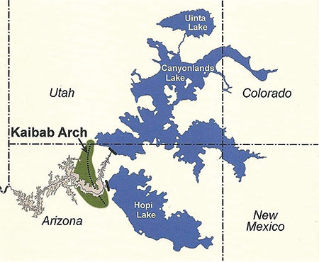
Fictional lakes that some creation geologists propose emptied in a catastrophic manner to carve Grand Canyon but are based on little if any geological evidence.
Image credit: Hill, C. et al, eds. 2016. The Grand Canyon, Monument to an Ancient Earth: Can Noah’s Flood Explain the Grand Canyon? Grand Rapids, MI: Kregel Publications, 163. Used in accordance with federal copyright (fair use doctrine) law. Usage by ICR does not imply endorsement of copyright holder.
A creation scientist critiques the “dammed lakes” theory.
Doesn’t a lot of this have to do with the impact episode around 12,000 to 13,000 years ago, and major melt-off that occurred with that?
Shall we?
The “Science” in this article is pitifully weak
A lot of conjecture with data not in evidence
Almost as bad as “Flat Earth” science
Ain't nature wonderful.
Butt, we should ban dinosaurs.
Look up Goosenecks Canyon as an example of a meandering river over flat terrain having the region uplifted. The meanders stayed in place as the river cut down.
It was not created by a little water over a long period of time. It was a large amount of water in a short period of time.
“I have his shoe! Follow the Shoe!!!”
Lately, that seems to describe more and more "science" as professors and researchers compete for big financial handouts to support their lifestyles.
That’s EXACTLY what he’s saying in the article.
He’s arguing it was in the post-Flood runoff stage, NOT in the post Ice-Age stage a few hundred years after the Flood.
It’s a good idea to read all of Michael Oard’s work on this issue before you criticize the lack of science.
“It’s a good idea to read all of Michael Oard’s work on this issue before you criticize the lack of science.”
not a lack ... a total void.
It took some time to figure out the great missoula flood, so maybe the time has come to solve this one, too.
Climate change concepts. Nonexistent lakes that become abandoned reservoirs from an advanced society that, like Atlantis, became drunk with power and destroyed themselves through failure to adopt the “green model”.
Agree completely
probably half of reviewed literature
contains significant embedded error
Actually, “as a rule of thumb,” water always finds the lowest points, and follows the paths of least resistance.
There is significant evidence of a monolithic catastrophic global flood event. In an effort to deny such an event, some evolutionist/geologist have gone so far as to take the theoretical position of numerous, or even up to thousands of floods happening simultaneously or near simultaneously around the globe.
The argument of large inland lakes or seas does not at all, diverge from a global flood. In fact, it very well compliments a massive flood event. It could even be argued, the significant bodies of salt water we have today around the globe, which are landlocked, could well be remnants of exactly such a global event. In my opinion, which is arguably not worth much, this is ultimately not an argument, or “hill to die on”.
Seashells, sedimentary sea fossils, and even bone and teeth of whales and sharks have been found at every continental latitude and every elevation group, on every continent and sub-continent. Pick Phoenix, AZ. the entire city and area are recognized as having been the sea floor. Trillions of seashells line the modern canals which have been dug. Abolone shells have been found near the Estrella park range, and ranges all across the desert. What many know of as “South Mountain” in Phoenix, is actually the “Wonder Rift”, a real precious metals bearing perpendicular rift in the sea floor.
This being said, and while nothing travels in a strait line, the Grand Canyon does run in a roughly East/West trend, which follows a massive exposed fault system, dissected by hundreds of smaller faults. Only the upper sedimentary layers would have been washed out quickly. The visible igneous and metamorphic rock layers in the Grand Canyon are actually more evidence of the main fault. Again, as a general rule around the world, water follows depressions created by faulting. As water from the flood, or possible remnant inland seas were emptied, the water would have followed these faulting routes, focusing the flow of water toward and through what we see today. Ultimately, it does not seem to be any kind of real problem, and actually may well be a compliment to the flood, to suggest large bodies of water were left over, at higher elevation, which would eventually flow along a fault structure.
Wow, I am opinionated...
Disclaimer: Opinions posted on Free Republic are those of the individual posters and do not necessarily represent the opinion of Free Republic or its management. All materials posted herein are protected by copyright law and the exemption for fair use of copyrighted works.
