Skip to comments.
Researchers: We may have found a fabled sunstone (Update)
Phys.org ^
| 08 March 2013
| Raphael Satter
Posted on 03/08/2013 11:05:59 AM PST by Red Badger
A rough, whitish block recovered from an Elizabethan shipwreck may be a sunstone, the fabled crystal believed by some to have helped Vikings and other medieval seafarers navigate the high seas, researchers say.
In a paper published earlier this week, a Franco-British group argued that the Alderney Crystal—a chunk of Icelandic calcite found amid a 16th century wreck at the bottom of the English Channel—worked as a kind of solar compass, allowing sailors to determine the position of the sun even when it was hidden by heavy cloud, masked by fog, or below the horizon.
That's because of a property known as birefringence, which splits light beams in a way that can reveal the direction of their source with a high degree of accuracy. Vikings may not have grasped the physics behind the phenomenon, but that wouldn't present a problem.
"You don't have to understand how it works," said Albert Le Floch, of the University in Rennes in western France. "Using it is basically easy." Vikings were expert navigators—using the sun, stars, mountains and even migratory whales to help guide them across the sea—but some have wondered at their ability to travel the long stretches of open water between Greenland, Iceland, and Newfoundland in modern-day Canada.
Le Floch is one of several who've suggested that calcite crystals were used as navigational aids for long summer days in which the sun might be hidden behind the clouds. He said the use of such crystals may have persisted into the 16th century, by which time magnetic compasses were widely used but often malfunctioned. Le Floch noted that one Icelandic legend—the Saga of St. Olaf—appears to refer to such a crystal when it says that Olaf used a "sunstone" to verify the position of the sun on a snowy day. But that's it. Few other medieval references to sunstones have been found, and no such crystals have ever been recovered from Viking tombs or ships. Until the Alderney Crystal was recovered in 2002, there had been little if any hard evidence to back the theory.
Many specialists are still skeptical. Donna Heddle, the director of the Center for Nordic Studies at Scotland's University of the Highlands and Islands, described the solar compass hypothesis as speculative. "There's no solid evidence that that device was used by Norse navigators," she said Friday. "There's never been one found in a Viking boat. One cannot help but feel that if there were such things they would be found in graves." She acknowledged that the crystal came from Iceland and was found near a navigation tool, but said it might just as easily have been used as a magnifying device as a solar compass. Le Floch argued that one of the reasons why no stones have been found before is that calcite degrades quickly—it's vulnerable to acid, sea salts, and to heat.
The Alderney Crystal was originally transparent, but the sea water had turned it a milky white. Le Floch's paper—written with Guy Ropars, Jacques Lucas, and a group of Britons from the Alderney Maritime Trust—appeared Wednesday in the Proceedings of the Royal Society A.
Read more at: http://phys.org/news/2013-03-fabled-sunstone.html#jCp
TOPICS: Canada; Culture/Society; US: Minnesota; United Kingdom
KEYWORDS: ancientnavigation; archeology; calcite; cordierite; ggg; godsgravesglyphs; iceland; middleages; navigation; renaissance; ships; sunstone; sunstones; thevikings; turmaline; vikings; vinland
Navigation: use the links below to view more comments.
first previous 1-20, 21-40, 41-47 last
To: Candor7
I might add that I myself have viewed some of the "historical record".
Some years ago, I visited the Three Rivers Petroglyphs in New Mexico -- between Carrizozo and Tularosa, at the foot of the Sacramento Mtns overlooking the Tularosa Basin.
Three Rivers
The site is a jumble of igneous rocks and boulders, generally about 3-5 ft high. The petroglyphs themselves are in profusion, but faded and somewhat indistinct -- to see them well, you really have to let your eyes adjust.
At one point, I sat down to rest in the shade of one boulder and looked at the boulders opposite that were highlighted by direct sun.
Suddenly, the faint forms fell into sharp focus. And one of the glyphs that stood out was a Viking ship in profile -- the high prow and stern, the square sail, the row of round shields along the gunwales.
The Three Rivers petroglyphs reportedly date to 1000-1400 AD. How did such an accurate depicition of a Viking ship appear in Southern New Mexico during this period if someone hadn't actually seen one?
41
posted on
03/08/2013 5:22:45 PM PST
by
okie01
(The Mainstream Media: IGNORANCE ON PARADE)
To: okie01; Candor7

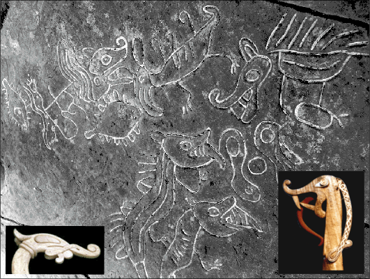
excerpt: Remaining in the Pacific Northwest, the question naturally arises as to whether representations of the "Sisuitl" might exist among the many petroglyphs in the region. Bearing in mind two things - firstly, the crocodilian snout plus the large eyes, and secondly, that an exact match with a Viking figurehead would be extremely difficult to emulate - its nevertheless seems that some examples of "Sea-Monster" petroglyphs do exist in this context, such as those found at Sproat Lake near Barkley Sound and Nanaimo. Oddly enough, in casting about for a suitable match, one of the most complex figureheads found was that used on the "Sigrid Storrada replica Viking Ship (lower right inset, Figure 7-1b below; Defunct link: http://www.sigrid-storrada.com/ ). This figurehead along with that of another working replica, the Danish Vikingship Helge Ask (lower left insert) are compared below with "Sea-monster" petroglyphs at Nanaimo on the east central coast of Vancouver Island, British Columbia:
SPIROSOLARIS LINK
42
posted on
03/08/2013 5:33:59 PM PST
by
Fred Nerks
(FAIR DINKUM!)
To: Fred Nerks
Fascinating, Fred.
Did the "long ships" actually make it to Vancouver Island...???
Or did an adventurous Viking somehow make his way from Lake Winnipeg to the Pacific coast...???
43
posted on
03/09/2013 10:01:01 AM PST
by
okie01
(The Mainstream Media: IGNORANCE ON PARADE)
To: okie01
http://www.spirasolaris.ca/sbb4g1bv3.html
It’s been a while since I first read all of this website, maybe the answer is there in part. There’s a fascinating section on Easter Island also, it shows structures that are remeniscent of structures on the island of St Kilda, in the Atlantic, off the New Hebredes. I’m inclined to think the Vikings (I think of them as Norwegan sailors) owned the oceans in the Northern hemisphere.
44
posted on
03/09/2013 2:49:32 PM PST
by
Fred Nerks
(FAIR DINKUM!)
To: okie01
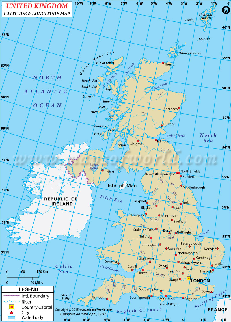
Sorry, I meant the OUTER Hebredes

It's on the island of St Kilda, not shown on the map, that one finds undated structures such as this, named cleits, supposedly constructed for storage of goodness knows what:

Which appear in similar appearance to structures found on Easter Island, described as chicken coops!
45
posted on
03/09/2013 4:42:08 PM PST
by
Fred Nerks
(FAIR DINKUM!)
To: okie01
46
posted on
03/09/2013 4:45:56 PM PST
by
Fred Nerks
(FAIR DINKUM!)
47
posted on
04/05/2018 7:32:17 AM PDT
by
SunkenCiv
(www.tapatalk.com/groups/godsgravesglyphs/, forum.darwincentral.org, www.gopbriefingroom.com)
Navigation: use the links below to view more comments.
first previous 1-20, 21-40, 41-47 last
Disclaimer:
Opinions posted on Free Republic are those of the individual
posters and do not necessarily represent the opinion of Free Republic or its
management. All materials posted herein are protected by copyright law and the
exemption for fair use of copyrighted works.
FreeRepublic.com is powered by software copyright 2000-2008 John Robinson
 excerpt: Remaining in the Pacific Northwest, the question naturally arises as to whether representations of the "Sisuitl" might exist among the many petroglyphs in the region. Bearing in mind two things - firstly, the crocodilian snout plus the large eyes, and secondly, that an exact match with a Viking figurehead would be extremely difficult to emulate - its nevertheless seems that some examples of "Sea-Monster" petroglyphs do exist in this context, such as those found at Sproat Lake near Barkley Sound and Nanaimo. Oddly enough, in casting about for a suitable match, one of the most complex figureheads found was that used on the "Sigrid Storrada replica Viking Ship (lower right inset, Figure 7-1b below; Defunct link: http://www.sigrid-storrada.com/ ). This figurehead along with that of another working replica, the Danish Vikingship Helge Ask (lower left insert) are compared below with "Sea-monster" petroglyphs at Nanaimo on the east central coast of Vancouver Island, British Columbia:

