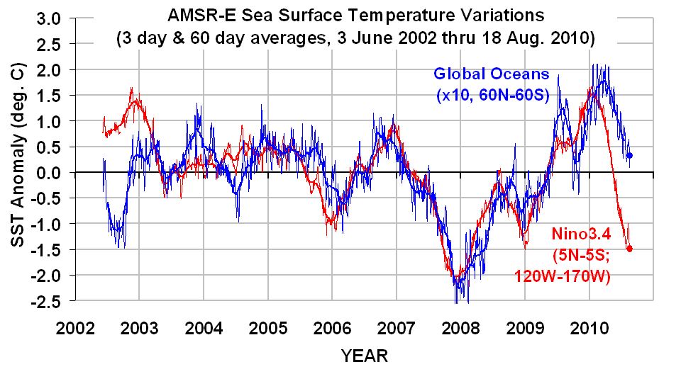
Average ocean temperature is still falling.

Antarctic Sea Ice Extent

Posted on 08/20/2010 1:15:33 PM PDT by presidio9
One hurricane, two tropical storms and five tropical depressions. That describes the 2010 Atlantic hurricane season so far. But, don't let your guard down. All signs point to a rapid increase in hurricane activity in the next two to three weeks.
Above normal temperatures in the Gulf of Mexico and the Caribbean would tend to favor hurricane growth and strength. This, plus the fact that water temperatures in the Equatorial Pacific Ocean are cooling. It's called La Nina and it means less wind shear in the Atlantic Ocean. Less wind shear gives Atlantic Hurricanes a favorable environment for rapid growth.
So far, there's not much to write home about. The strongest hurricane to form was a weak Category 1 storm, Alex, that moved on shore near Brownsville, Texas in June. Hurricane development has been suppressed by dry mid-level air and upper level wind shear blowing the cloud tops off.
We are also approaching the peak of hurricane season. Based on the NOAA historical tropical storm and hurricane frequency, an uptick in activity is a good bet heading toward the September 10 average maximum. Throughout history, more hurricanes have occurred on September 10th than on any other day of the year (See Figure 1).
So, things are primed and ready to fire, it’s just that the trigger isn’t there yet, but it’s coming. (Barring unforeseen events. There’s always that out….)
WOW, Hurricanes around Labor Day! These guys are good!.....................
So far, the shear from upper level lows has ripped all the disturbances to shreds, despite high water temperatures.
Lack of strong high-altitude winds (shear) plays as large a role in cyclogenesis as sea-surface temperatures.
Actually, if you’ll check it, you’ll find that the predictions fluctuate from year to year.
What bugs me is when people just assume that every hurricane is caused by Global Warming. There’s a lot of evidence that a warming world would, if anything, suppress hurricane activity in the Atlantic. Wind shear eats hurricanes for lunch.
Sure, I have family business in fla this month.. how “perfect”
It’s the same dire prediction as last year.
Yawn... wake me up when the NFL season starts. ; )
I live on the gulf coast and I have not been impressed at all with their forecasting. Twice we’ve been under a tropical storm watch they had to cancel because the storms died out from depressions to lows. The storms have done the exact opposite of what they were forcast to do.


Actually, the 2009 prediction was for an “above average hurrican season,” whatever that, means according to this article:
http://www.cnn.com/2008/WORLD/weather/12/10/hurricane.season.2009/index.html
Last year’s actual numbers turned out to be below average.
Official word from BrainWashington:
“The hurricanes are Bush’s fault and they are racist.”
Hmmmmmm...one must remember that the 2008 Hurricane Ike went through the Gulf States Sep 11-12 and the remnants of that Hurricanse went through the Midwest Sep 13-15
The Weather Channel was showing a large plume of Saharan dust at above 15,000 ft. in the Atlantic. Developing storms hate dust.
http://wattsupwiththat.com/2010/08/15/thoughts-on-2010-hurricane-season-so-far/
Thoughts on 2010 hurricane season so far
by Steve Goddard
(go to link to see graphs, pics and video.)
The Atlantic Hurricane Basin remains dead quiet, and is now falling below the 1944-2005 average.
I have not spent a lot of time studying hurricanes, but I have read that the “purpose” of hurricanes is to move heat quickly from the tropics to higher latitudes. Heat flow is always driven by differences in temperature. If two places were at the same temperature, there would be no heat flow.
Suppose that temperatures at higher latitudes (60N) were very warm – as they have been. What motivation would there be for hurricanes to form? The video and stil below shows UNISYS SST anomalies, with all anomalies between -1.0°C and +1.0°C removed.
Note that the Atlantic hurricane basin has very few places which are warmer than 1.0°C above normal. This agrees with Bob Tisdale’s graph.
By contrast, SST anomalies in the North Atlantic are far above normal. The difference in temperature between the tropical and north Atlantic is far below normal. Supposedly, it is that difference which gives hurricanes their raison d’être .
Things can change quickly. 1950 was the second most active hurricane season on record, and the first hurricane didn’t form until August 12.
Does it make sense that the heat engine which drives hurricane formation is basically shut down? What do you think?
That's right, folks. GLOBAL COOLING increases hurricane activity. It's sort of a planetary second chakra release.
or even close??
Won't be an issue soon, as the EPA gets their act in gear, and regulates dust from existence. After that, hurricanes will be able to form freely, and reign.
Disclaimer: Opinions posted on Free Republic are those of the individual posters and do not necessarily represent the opinion of Free Republic or its management. All materials posted herein are protected by copyright law and the exemption for fair use of copyrighted works.