Posted on 04/03/2023 5:22:42 AM PDT by Red Badger
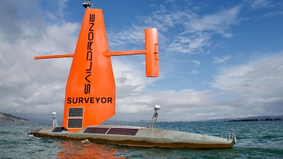
After surveying 45,000 square kilometers of once mysterious ocean floor around Alaska’s Aleutian Islands, the uncrewed sailing drone Surveyor moved far to the south, discovering a previously unknown seamount within 200 miles of the NorCal coast.
The safety-orange sailing ship is no stranger to adventure; it gathered carbon data from the Gulf Stream, mapped the seafloor from San Francisco to Hawaii, and weathered the 120-mph winds and 50-foot waves of Hurricane Sam.
The seamount is the slumbering remains of an undersea volcano; these watery mountains were once considered little more than navigational hazards for submarines until scientists uncovered the richness of the sea life they support, NOAA explains.
Studying them not only helps us understand current marine life, but also the physical processes of the ocean, Saildrone said in a release. The seamount was found 184 nautical miles from Cape Mendocino, the Sacramento Bee reported, and it towers 3,200 feet above the seafloor, with about 1,200 feet of Pacific between its crowning crater and the surface.
That means it stands outside of the usual area for California seamounts, expanding their known range, NOAA Ocean Exploration Cooperative Institute manager Aurora Elmore told SFGATE.
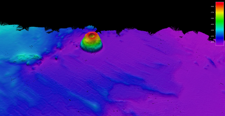
The newly-discovered seamount as mapped by Saildrone Surveyor. Saildrone/NOAA
And, Elmore noted, that crater rests atop an unusual shape. “Typically seamounts have sloped sides, like Mount Fuji,” she said. “But what’s interesting about this one is that it’s really steep. It rises from the bottom of the seafloor with a tower shape.”
The Saildrone team’s first impression was that it looked like an enormous Bundt cake, lead surveyor Neah Baechler told the Bee: “One side of the top rim is higher than the other, forming a gradual summit. … The top is slightly bulbous, due to variability in slope.”
Baechler told SFGATE that a Bundt shape isn’t unusual per se, but the sheer size of it is, with most similarly-shaped features not rising to the heights required of a seamount.
Elmore theorized that the unusual shape may be because the seamount — which has yet to be named — was formed in volcanic activity that was super hot and super quick, or it could have developed its steep sides by a piling on of marine snow that sharpened the slopes.
Or, as Elmore put it: “Millennia of fish poop.”
They ‘Follow the science...” until it leads to somewhere they do not want to go......................
Vietnam was a watershed moment for them, then they patiently spent the following decades making it happen.
If you control the narrative, the ‘science’ is whatever you say it is...
...and that’s exactly where we’re at.
Nails it at 13.
“Those who control the present, control the past and those who control the past control the future.”
― George Orwell, 1984
ya I thought that but worded it wrong comparing it to a auto pilot. But in all the pictures I seen, that looked like a rigid mount where the horizontal of the weather vane arm meets the sail. there was no evidence of a pivot point. also the wind catch on the vane would be on one side only meaning the tack could only be in the direction of a starboard wind. thats where im thrown...
mann I just noticed it may be in line with the sail!! lol... my total bad.
The deepest free dive by a man was 702 feet, but a submersible record has been around 35,000 feet. Thus 12,000 feet should be extremely doable to get actual photographs or even video.
I assume what we are seeing is some sort representation of it, rather than being an exacting image of it. Let's get some detailed images. Would be more interesting. I'll bet it's not nearly as symmetrical as it appears to be with whatever it is we are seeing. That was the point of my post.
I am sure that the oceanographers are planning to do just that, explore it with a submersible as soon as they can possibly get the time and funding to do so.................
So if one reads the article, it is not so mysterious.
The only thing I find odd about it is why was it never discovered before, since the US Navy makes topographical maps of the seafloor, and nothing has run into it....................
I would think so. 🙂
Disclaimer: Opinions posted on Free Republic are those of the individual posters and do not necessarily represent the opinion of Free Republic or its management. All materials posted herein are protected by copyright law and the exemption for fair use of copyrighted works.