Also from the article:
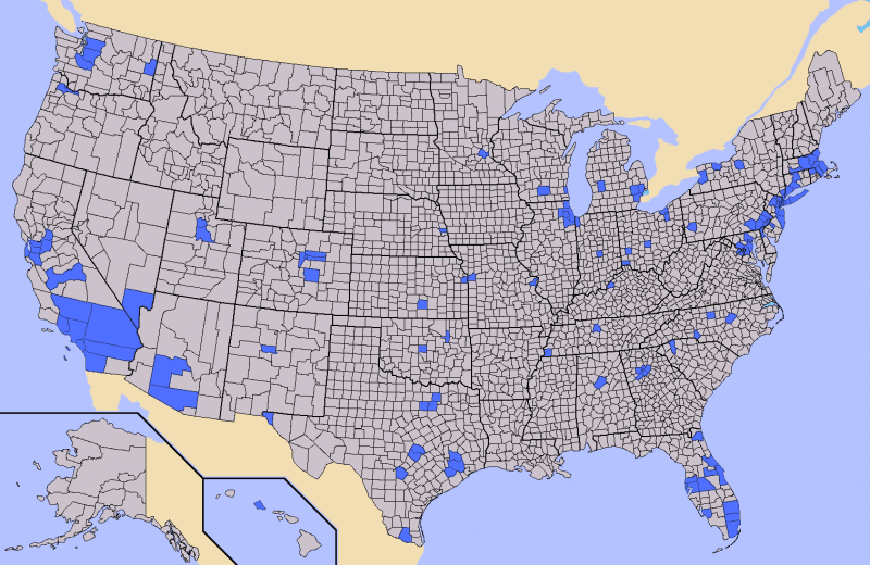
When considering your retreat locations or emergency evacuation routes, be familiar with the population densities of the area you’re headed to, as well as those counties in your immediate vicinity.
The best BOL in the world might as well be on the darkside of the moon if you can't get to it!
Navigation: use the links below to view more comments.
first 1-20, 21-35 next last
To: appalachian_dweller; OldPossum; DuncanWaring; VirginiaMom; CodeToad; goosie; kalee; ...
2 posted on
09/05/2013 4:23:40 PM PDT by
Kartographer
("We mutually pledge to each other our lives, our fortunes and our sacred honor.")
To: stylecouncilor
Ain’t that Greenville County?
3 posted on
09/05/2013 4:25:23 PM PDT by
onedoug
To: Kartographer
I can’t imagine feral urban looters running a muck out in the San Bernadino desert and Death Valley. Maybe the map just colored counties without accounting for open spaces and urban proximity.
4 posted on
09/05/2013 4:29:29 PM PDT by
Baynative
(Lord, keep your arm around my shoulder and your hand over my mouth.)
To: Kartographer
I’m two counties away from Detroit but I’m good.
6 posted on
09/05/2013 4:32:13 PM PDT by
cripplecreek
(REMEMBER THE RIVER RAISIN!)
To: Kartographer
Oh, Goodie! Dane and Milwaukee Counties in Wisconsin! ‘The People’s Republik of Madistan’ WILL explode with unrest if the ‘White Wine and Brie Crowd’ is denied their treats and Cigar Bars (exempt from Smoking Ban Rules, of course!) right off the Capitol Square. Inconvenience our Local Liberal Legislators and YOU WILL PAY! *SMIRK*
Thank goodness I can head west to Iowa County (where our ‘big’ farm is located*) and then, if necessary, on to Idaho where my survivalist Bestie lives, though Beau is a crack shot and will defend us IF the Zombies can find us. :)
*It took me nearly a year WITH A MAP to easily find my way out there; I can find it now, sans map!
8 posted on
09/05/2013 4:33:31 PM PDT by
Diana in Wisconsin
(I don't have 'Hobbies.' I'm developing a robust Post-Apocalyptic skill set...)
To: Gabz
You area looks safe - I’d come to YOU, but I’d have to shoot my way through Chi-Town to do it...and I don’t want to be responsible for THAT many deaths, LOL!
9 posted on
09/05/2013 4:35:42 PM PDT by
Diana in Wisconsin
(I don't have 'Hobbies.' I'm developing a robust Post-Apocalyptic skill set...)
To: Kartographer
I would guess that the author failed to take into account that not all urban areas are created equal.
I suspect that the Salt Lake area will be much safer than NYC due to a much higher percentage of people who have made preparations...
10 posted on
09/05/2013 4:37:14 PM PDT by
null and void
(I'm betting on an Obama Trifecta: A Nobel Peace Prize, an Impeachment, AND a War Crimes Trial...)
To: Kartographer
Which Hawaiian Island is that? I’ve been to Kauai...they have a Wal-Mart! A well-hidden, Wal-Mart, but still.
Betcha there’s no ammo to be found at THAT Wal-Mart, either!
11 posted on
09/05/2013 4:37:34 PM PDT by
Diana in Wisconsin
(I don't have 'Hobbies.' I'm developing a robust Post-Apocalyptic skill set...)
To: Kartographer
I’m not worried about the DC metro. The core will always be supplied with power, water, police/military.
I saw this first hand. They’d better be because the only ones prepared during 2012’s drecho were those who had served and knew what to keep at home. The rest of the public, brilliant though they may be, were unprepared. I still warn some people, but it just doesn’t register.
I hope those I know can make it to my swamp along with those who live here already but hey, whatever comes, comes.
12 posted on
09/05/2013 4:37:34 PM PDT by
OpusatFR
To: Kartographer
bump
can someone take the night map of the US and black out all of these counties??
17 posted on
09/05/2013 4:41:26 PM PDT by
GeronL
To: Kartographer
I can see Denver county, Colorado, but Adams county?
Lots of farmers in that area. Many good conservative folks.
20 posted on
09/05/2013 4:43:18 PM PDT by
RandallFlagg
(IRS = Internal Revenge Service)
To: Kartographer
What! NO New Awleans? No Lil Rock! No Pine Bluff? No Shereveport? No Amarillo?
This map is partially worthless!
21 posted on
09/05/2013 4:43:52 PM PDT by
Ruy Dias de Bivar
(Sometimes you need 7+ more ammo. LOTS MORE.)
To: Kartographer
Looks the map of blue counties that gave the election to BHO, btw. Only here the red counties are gray.
23 posted on
09/05/2013 4:45:14 PM PDT by
StAntKnee
(Add your own danged sarc tag)
To: Kartographer
I am too $#%@ close to Atlanta.
25 posted on
09/05/2013 4:46:28 PM PDT by
FreeAtlanta
(Liberty or Big Government - you can't have both.)
To: Kartographer
Try this one on for size.
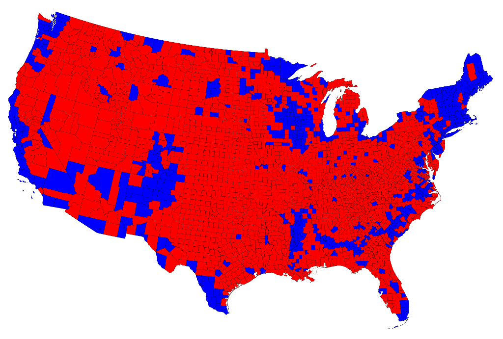
Source = http://www-personal.umich.edu/~mejn/election/2012/countymaprb1024.png
30 posted on
09/05/2013 4:51:45 PM PDT by
fulltlt
To: Kartographer
I feel pretty good about Tarrant County, Texas.
31 posted on
09/05/2013 4:52:36 PM PDT by
Dysart
To: Kartographer
I35 is the main N-S route through TX - draw a line from blue San Antonio, blue Austin and north to blue Dallas. It will be locked down within the first hours. Down south in San Antonio, there will be a mad exodus of illegals headed to the border. The illegals who inhabit the east side of I35 in Austin will immediately head to the liberal west side of I35 for their rampaging. The blacks who took over Oak Cliff in south Dallas will meet anyone coming north and east Dallas will cross the highway to hit the wealthy in north Dallas. Funny how closely the blue on this map matches the blue on the election map.
32 posted on
09/05/2013 4:52:46 PM PDT by
bgill
(This reply was mined before it was posted.)
To: Kartographer
Actually Jefferson County, CO is a great place to be. Only a small portion of it is in the metro area, the rest is mountains.
35 posted on
09/05/2013 4:53:32 PM PDT by
CodeToad
(Liberals are bloodsucking ticks. We need to light the matchstick to burn them off. -786 +969)
To: Kartographer
Well Janet the Nap did make that cryptic comment about a upcoming cyber attack and natural disaster of unprecedented proportions when she retired. I wonder when she got the ability to predict “natural” disasters or maybe she was just engaging a little hyperbole for dramatic effect I would like to think that is the case.
36 posted on
09/05/2013 4:54:17 PM PDT by
Polynikes
(What would Walt Kowalski do. In the meantime "GET OFF MY LAWN")
To: Kartographer
I doubt Guilford County NC will have many problems. The rural parts will hold their own.
43 posted on
09/05/2013 5:00:39 PM PDT by
AppyPappy
(Obama: What did I not know and when did I not know it?)
Navigation: use the links below to view more comments.
first 1-20, 21-35 next last
FreeRepublic.com is powered by software copyright 2000-2008 John Robinson