Posted on 09/02/2013 4:43:48 PM PDT by rjbemsha
A meteor or comet impact near Quebec heaved a rain of hot melted rock along North America's Atlantic Coast about 12,900 years ago, a new study claims.
Scientists have traced the geochemical signature of the BB-sized spherules that rained down back to their source, the 1.5-billion-year-old Quebecia terrane in northeastern Canada near the Gulf of Saint Lawrence. At the time of the impact, the region was covered by a continental ice sheet, like Antarctica and Greenland are today.
Around this time, a global cooling began and the big animals in North America all vanished. Their human hunters, the Clovis people, turned to a hunter-gatherer subsistence diet of roots, berries, and smaller game.
The cooling has been attributed to a sudden shutdown in Northern Atlantic Ocean currents, caused by a big glacial lake flood out the St. Lawrence or Mackenzie Rivers. But in 2007, scientists suggested that comet or meteor impacts or atmospheric fireballs triggered the Younger Dryas, though no crater of the right age has ever been found.
(Excerpt) Read more at news.yahoo.com ...
For the last time, I wasn’t the one manning the meteor-redirection ray that day!
This tracing the Atlantic coast tectites to the Laurentian Shield is an exciting new find, but the Firestone book tells a pretty clear story. Also, he shows an underwater map of Lake Michigan and says it shows 2 craters. However, looking at it carefully I feel I identify 3. Kind of like this: OoO. Looks a little like an ant body. Check it out, tell me if you see it too.
If you read Firestone’s book you will see that debris has been found a lot farther south than NJ.
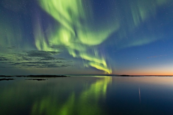
YOu might like this picture: http://d1jqu7g1y74ds1.cloudfront.net/wp-content/uploads/2013/09/aurora-olsen-580x386.jpg
An aurora seen in Norway on Aurora Borealis from September 2, 2013. Credit and copyright: Frank Olsen.
Read more: http://www.universetoday.com/#ixzz2dq1cgD23
Very interesting....
Some comet material can be found on Mars too.
Firestone mentioned Mars and the Moon as indications of the direction of entry into our solar system.
I know for a fact that New England was an impact site but there is some sort of strange connection to the Carolina Bays as well. Perhaps the wave of debris that caused the comet swept many different substances with it. Still, Carolina Bays were not under an ice sheet. The ice sheet did not extend that far south 12,900 years ago.
My theory is that the Carolina Bays were formed when gigantic chunks of ice were thrown out of the ice sheet by impact, and then melted. If I remember correctly, the book SC posted said something about CB type shapes found elsewhere, and that lines along the long axis of the oval mostly pointed toward Lake Michigan. Since there may have been more than one boloid strike, other bays could also have been produced with a different axis orientation.
Can you imagine what the tsunami must have been like?
I just came back from a week away. I have a lot of mail to process but will read your links in the next few days. Thanks.
Interesting the legend refers to the St Lawrence river by the name given to it by the Europeans.
This is information given by Darren Bonaparte in his book so readers would know what the heck to which river the talkers were referring because they are speaking in Iroquois language which most people cannot understand...
St. Lawrence valley = “Kaniatarowanenneh” in Iroquois
Disclaimer: Opinions posted on Free Republic are those of the individual posters and do not necessarily represent the opinion of Free Republic or its management. All materials posted herein are protected by copyright law and the exemption for fair use of copyrighted works.