
I do as well.
‘Wonder what Mark Twain might have thought.
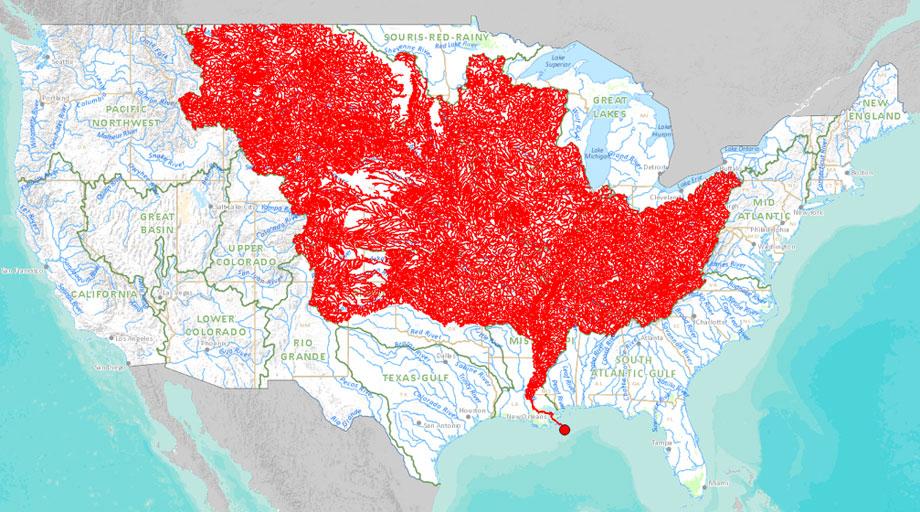
Pretty amazing how much of our nation “drains” down the Mississippi!
I used to live about a mile from the watershed demarcation in Ohio. I was on the side that drained to the Great Lakes, but about a mile south of me, the streams flowed generally to the Tuscarawas River, eventually leading to the Ohio and then the Mississippi River.
I'm still amazed that our parents allowed us to take the trip. There were very few houses along the way, and we spent quite a few hours lost in mazes of wild rice. The route we took shows up on the interactive map.
PING
It’s not real inclusive just from looking for the streams in my area.
How convenient, now they can show how your bath tub is a navigable waterway or declare it a wetland.
Here's a map for you...... The Great River Road. It is a marked series of roads and Hiways from Lake Istasca Minnesota to Venice Louisana following the river. It is about 2,300 miles through the heartland and a great excursion. It passes through many small towns and several cities. It is America at it's best
Water! I like water...
This Mississippi is improperly named. It starts in Minnisota where it flows into the Missouri at St Louis. The Missouri is the dominant river, and it is the Missouri that flows from way out west...
The Missouri River is the longest river in North America,[11] longest tributary in the United States and a major waterway of the central United States. Rising in the Rocky Mountains of western Montana, the Missouri flows east and south for 2,341 miles (3,767 km)[7] before entering the Mississippi River north of St. Louis, Missouri. The river takes drainage from a sparsely populated, semi-arid watershed of more than half a million square miles (1,300,000 km2), which includes parts of ten U.S. states and two Canadian provinces. When combined with the lower Mississippi River, it forms the world’s third longest river system.
For over 12,000 years, people have depended on the Missouri and its tributaries as a source of sustenance and transportation. More than ten major groups of Native Americans populated the watershed, most leading a nomadic lifestyle and dependent on enormous buffalo herds that once roamed through the Great Plains. The first Europeans encountered the river in the late seventeenth century, and the region passed through Spanish and French hands before finally becoming part of the United States through the Louisiana Purchase. The Missouri was long believed to be part of the Northwest Passage – a water route from the Atlantic to the Pacific – but when Lewis and Clark became the first to travel the river’s entire length, they confirmed the mythical pathway to be no more than a legend.
Thanks blam, one of my kids is testing stream water this summer as part of her internship.