Peak of hurricane season is fast approaching.
Navigation: use the links below to view more comments.
first 1-20, 21 next last
To: abb; abbi_normal_2; aberaussie; alancarp; Alas Babylon!; Alia; Alice in Wonderland; ...
Heads up Florida, GOM... 
On/Off Hurricane List Mash Here-->
2 posted on
08/25/2008 8:30:09 AM PDT by
NautiNurse
(Plants are people too)
To: NautiNurse
TS Fay rained on me all night last night. It looks like it may clear up for a while now.
3 posted on
08/25/2008 8:30:27 AM PDT by
blam
To: NautiNurse
Oh dear I just told Mr. Ditter there wasn't one out there. We are planning on a week out of the state starting Thursday, here's hoping it doesn't come to Texas.
5 posted on
08/25/2008 8:33:25 AM PDT by
Ditter
To: NautiNurse
I am known to my friends as the human barometer.
This am I was dreaming about my pain, unable to wake up. I am really hurting now, even after breakfast. I have a feeling we are in for some good storming.
10 posted on
08/25/2008 8:38:29 AM PDT by
I still care
("Remember... for it is the doom of men that they forget" - Merlin, from Excalibur)
To: NautiNurse
I was looking at that this morning as I was checking on Fay. Fay has ended our drought.
14 posted on
08/25/2008 8:49:35 AM PDT by
Jemian
(If you laid all the people in China end to end around the world...... 70% of them would drown.)
To: NautiNurse
I was looking at that this morning as I was checking on Fay. Fay has ended our drought.
15 posted on
08/25/2008 8:49:42 AM PDT by
Jemian
(If you laid all the people in China end to end around the world...... 70% of them would drown.)
To: NautiNurse
Figures, we are due to leave for Destin area day after Labor Day.
When will we ever learn?!!!
sw
16 posted on
08/25/2008 8:54:07 AM PDT by
spectre
(Spectre's wife (Is He the one?)
To: NautiNurse
Centered over Denver?
Garde la Foi, mes amis! Nous nous sommes les sauveurs de la République! Maintenant et Toujours!
(Keep the Faith, my friends! We are the saviors of the Republic! Now and Forever!)
LonePalm, le Républicain du verre cassé (The Broken Glass Republican)
18 posted on
08/25/2008 9:03:37 AM PDT by
LonePalm
(Commander and Chef)
To: NautiNurse
19 posted on
08/25/2008 9:15:17 AM PDT by
NonValueAdded
(Rest In Peace, Capt. Ed "Too Tall" Freeman (1928-2008))
To: JulieRNR21; kinganamort; katherineisgreat; floriduh voter; summer; Goldwater Girl; windchime; ...

Florida Freeper

29 posted on
08/25/2008 9:50:31 AM PDT by
Joe Brower
(Sheep have three speeds: "graze", "stampede" and "cower".)
To: NautiNurse
Whoa!!!
My son has been waiting for 10 days to get a home owner’s insurance binder on a Florida home he is buying. There wasn’t a business day last week that any agents could write Florida coverage.
Got it paid for and bound coverage this morning. Hope we get through a Wednesday closing before the forecasts are announced!
To: NautiNurse
Recon data says this is Gustav... not sure if they’ll upgrade before 5 or not, but it’s possible.
42 posted on
08/25/2008 10:46:00 AM PDT by
nwctwx
To: NautiNurse; SouthTexas
127 posted on
08/26/2008 3:28:47 AM PDT by
flattorney
(See my comprehensive FR Profile "Straight Talk" Page)
To: NautiNurse
they’ll ship H to avoid calling it hilary, Irene comes next.
151 posted on
08/26/2008 5:50:00 AM PDT by
Waco
To: NautiNurse
To: NautiNurse
Does anyone here subscribe to Larry Cosgrove’s e mail list? I had a crash and lost last Sunday’s e mail. Any help would be greatly appreciated.
163 posted on
08/26/2008 7:30:09 AM PDT by
GregB
(Never forget Lance Cpl. Juan Lopez-Castaneda!!!!!!!)
To: NautiNurse
I’m going to laugh my butt off if this thing slams into NOLA.
189 posted on
08/26/2008 8:27:27 AM PDT by
Centurion2000
(Define yourself by what you do, not by your ideology, belief, origins, genitals, etc ....)
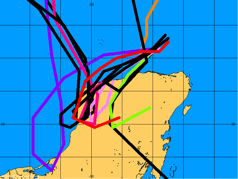
To: NautiNurse; SouthTexas
Latest Gustav Long Term

267 posted on
08/26/2008 12:16:06 PM PDT by
flattorney
(See my comprehensive FR Profile "Straight Talk" Page)
To: NautiNurse
Bad one for sure......Prayers up for all GOM FR peers...
To: NautiNurse
TROPICAL STORM GUSTAV DISCUSSION NUMBER 9
NWS TPC/NATIONAL HURRICANE CENTER MIAMI FL AL072008
500 AM EDT WED AUG 27 2008
GUSTAV HAS BEEN HUGGING THE NORTH COAST OF SOUTHWESTERN HAITI THIS MORNING WITH STRONG BANDS OF THUNDERSTORMS TO THE EAST AND SOUTH OF THE CENTER. AN AIR FORCE RESERVE RECONNAISSANCE PLANE FOUND A MINIMUM PRESSURE OF 998 MB AND RELIABLE SFMR WINDS OF 45-50 KT. THE INITIAL INTENSITY WILL BE SET AT 50 KT. LITTLE INTENSIFICATION IS FORESEEN UNTIL THE CENTER MOVES FARTHER AWAY FROM THE HIGH TERRAIN OF HAITI. THEREAFTER...A STEADY INCREASE IN STRENGTH IS LIKELY... ESPECIALLY AFTER THE CENTER MOVES INTO THE MORE OPEN WATERS NORTHWEST OF JAMAICA. VERTICAL SHEAR IS FORECAST TO BE LIGHT...AND COMBINED WITH THE DEEP WARM WATERS...RAPID INTENSIFICATION COULD OCCUR IN A COUPLE OF DAYS WHILE THE CENTER IS NEAR OR SOUTH OF WESTERN CUBA.
THE OFFICIAL FORECAST IS REDUCED FROM EARLIER DUE TO THE INITIAL WEAKENING BUT STILL SHOWS THE STORM BECOMING A MAJOR HURRICANE IN THE NORTHWESTERN CARIBBEAN SEA. IN THE LONGER-TERM... THE GLOBAL MODELS HAVE A VARIETY OF UPPER-WIND PATTERNS...BUT IN GENERAL THE
UPPER WINDS APPEAR TO BE FAVORABLE ENOUGH TO SUPPORT A MAJOR HURRICANE IN THE GULF OF MEXICO. IT SHOULD BE NOTED THAT BOTH THE GFDL AND HWRF ARE MORE AGGRESSIVE THAN THE OFFICIAL FORECAST.
FORECAST POSITIONS AND MAX WINDS
INITIAL 27/0900Z 18.6N 73.5W 50 KT
12HR VT 27/1800Z 19.0N 74.3W 50 KT
24HR VT 28/0600Z 19.1N 75.6W 60 KT
36HR VT 28/1800Z 19.2N 77.2W 70 KT
48HR VT 29/0600Z 19.6N 78.8W 80 KT
72HR VT 30/0600Z 21.0N 82.5W 100 KT
96HR VT 31/0600Z 23.5N 86.0W 105 KT
120HR VT 01/0600Z 27.0N 89.5W 105 KT
$$
FORECASTER BLAKE/AVILA
LATEST:

 #1 U.S. consolidated tropical storms and hurricanes information site on the internet.
FR Threads: Hurricane | Tropical | Weather
Hurricane Season: June 1 - November 30, 2008 | National Hurricane Center | Current Atlantic Basin Activity
Add'l Tropics Tracking: Navy | Wunderground | Dr. Masters | Hurricane City | Florida Hurricane Center | TBO
Spaghetti Models: BoatUS | CSU | MIT || Steering Layers | ND Buoy Center | NODC Water Temps | Knots to MPH
Images: NHC | NOAA HQ | NASA GOES
Key Biscayne-Miami Weather | Radar | Biscayne Bay Marine Forecast | U.S. Weather Surface Map

Oct 24, 2005, 7:30 pm - Before and after Hurricane Wilma caused the largest power outage in Miami-Dade's history.
355 posted on
08/27/2008 3:32:34 AM PDT by
flattorney
(See my comprehensive FR Profile "Straight Talk" Page)
Navigation: use the links below to view more comments.
first 1-20, 21 next last
FreeRepublic.com is powered by software copyright 2000-2008 John Robinson
