
Posted on 08/25/2008 8:27:52 AM PDT by NautiNurse
Tropical Depression 7 has formed in the eastern Caribbean.
Buoy Data:
East Caribbean Buoys
West Caribbean Buoys
Florida Buoys
| Category | Wind Speed | Barometric Pressure | Storm Surge | Damage Potential |
|---|---|---|---|---|
| Tropical Depression |
< 39 mph < 34 kts |
Minimal | ||
| Tropical Storm |
39 - 73 mph 34 - 63 kts |
Minimal | ||
| Hurricane 1 (Weak) |
74 - 95 mph 64 - 82 kts |
28.94" or more 980.02 mb or more |
4.0' - 5.0' 1.2 m - 1.5 m |
Minimal damage to vegetation |
| Hurricane 2 (Moderate) |
96 - 110 mph 83 - 95 kts |
28.50" - 28.93" 965.12 mb - 979.68 mb |
6.0' - 8.0' 1.8 m - 2.4 m |
Moderate damage to houses |
| Hurricane 3 (Strong) |
111 - 130 mph 96 - 112 kts |
27.91" - 28.49" 945.14 mb - 964.78 mb |
9.0' - 12.0' 2.7 m - 3.7 m |
Extensive damage to small buildings |
| Hurricane 4 (Very strong) |
131 - 155 mph 113 - 135 kts |
27.17" - 27.90" 920.08 mb - 944.80 mb |
13.0' - 18.0' 3.9 m - 5.5 m |
Extreme structural damage |
| Hurricane 5 (Devastating) |
Greater than 155 mph Greater than 135 kts |
Less than 27.17" Less than 920.08 mb |
Greater than 18.0' Greater than 5.5m |
Catastrophic building failures possible |
Tropical Storm GUSTAV Public Advisory
000
WTNT32 KNHC 270836
TCPAT2
BULLETIN
TROPICAL STORM GUSTAV ADVISORY NUMBER 9
NWS TPC/NATIONAL HURRICANE CENTER MIAMI FL AL072008
500 AM EDT WED AUG 27 2008
...GUSTAV STALLS...HEAVY RAIN SQUALLS OVER HAITI...
AT 5 AM...0900 UTC...THE HURRICANE WARNING FOR HAITI FROM THE
DOMINICAN REPUBLIC-HAITI BORDER WESTWARD TO LE MOLE ST NICHOLAS HAS
BEEN CHANGED TO A TROPICAL STORM WARNING. A TROPICAL STORM WARNING
IS NOW IN EFFECT FOR HAITI FROM THE DOMINICAN REPUBLIC-HAITI BORDER
WESTWARD TO LE MOLE ST NICHOLAS. A TROPICAL STORM WARNING MEANS
THAT TROPICAL STORM CONDITIONS ARE EXPECTED WITHIN THE WARNING AREA
WITHIN THE NEXT 24 HOURS.
AT 5 AM...THE HURRICANE WATCH FOR HAITI FROM LE MOLE ST NICHOLAS TO
THE NORTHERN HAITI/DOMINICAN REPUBLIC BORDER HAS BEEN CHANGED TO A
TROPICAL STORM WATCH. A TROPICAL STORM WATCH IS NOW IN EFFECT FOR
HAITI FROM LE MOLE ST NICHOLAS TO THE NORTHERN HAITI/DOMINICAN
REPUBLIC BORDER. A TROPICAL STORM WATCH MEANS THAT TROPICAL STORM
CONDITIONS ARE POSSIBLE WITHIN THE WATCH AREA...GENERALLY WITHIN 36
HOURS.
AT 5 AM...THE GOVERNMENT OF JAMAICA HAS ISSUED A TROPICAL STORM
WARNING FOR JAMAICA. A HURRICANE WATCH AND A TROPICAL STORM
WARNING ARE NOW IN EFFECT FOR JAMAICA.
A HURRICANE WARNING REMAINS IN EFFECT FOR CUBA FOR THE PROVINCES OF
GUANTANAMO...SANTIAGO DE CUBA...AND GRANMA.
A HURRICANE WATCH REMAINS IN EFFECT FOR THE CUBAN PROVINCES OF LAS
TUNAS AND HOLGUIN AND ALL OF THE CAYMAN ISLANDS.
INTERESTS IN CENTRAL AND WESTERN CUBA SHOULD CLOSELY MONITOR THE
PROGRESS OF GUSTAV.
FOR STORM INFORMATION SPECIFIC TO YOUR AREA...INCLUDING POSSIBLE
INLAND WATCHES AND WARNINGS...PLEASE MONITOR PRODUCTS ISSUED
BY YOUR LOCAL WEATHER OFFICE.
AT 500 AM EDT...0900Z...THE CENTER OF TROPICAL STORM GUSTAV WAS
LOCATED NEAR LATITUDE 18.6 NORTH...LONGITUDE 73.5 WEST OR ABOUT 80
MILES...125 KM...WEST OF PORT AU PRINCE HAITI AND ABOUT 155 MILES...
250 KM...SOUTHEAST OF GUANTANAMO CUBA.
GUSTAV HAS NOT MOVED MUCH DURING THE PAST FEW HOURS...BUT IS
EXPECTED TO RESUME A MOTION TOWARD THE WEST-NORTHWEST NEAR 5
MPH...7 KM/HR SOON. A WEST-NORTHWEST TO WEST TRACK IS FORECAST
DURING THE NEXT DAY OR TWO WITH A GRADUAL INCREASE IN FORWARD
SPEED. ON THE FORECAST TRACK...GUSTAV SHOULD PASS BETWEEN JAMAICA
AND THE SOUTHEASTERN COAST OF CUBA ON THURSDAY.
MAXIMUM SUSTAINED WINDS REMAIN NEAR 60 MPH...95 KM/HR...WITH HIGHER
GUSTS. SLOW STRENGTHENING IS FORECAST AND GUSTAV COULD REGAIN
HURRICANE STRENGTH ON THURSDAY ONCE IT MOVES AWAY FROM HAITI.
TROPICAL STORM FORCE WINDS EXTEND OUTWARD UP TO 50 MILES...85 KM
FROM THE CENTER.
THE LATEST CENTRAL PRESSURE AS ESTIMATED FROM AN AIR FORCE RESERVE
RECONNAISSANCE PLANE IS 998 MB...29.47 INCHES.
GUSTAV IS EXPECTED TO PRODUCE TOTAL RAINFALL ACCUMULATIONS OF 6 TO
12 INCHES OVER HISPANIOLA...EASTERN CUBA...JAMAICA...AND THE CAYMAN
ISLANDS...WITH ISOLATED MAXIMUM AMOUNTS OF UP TO 25 INCHES
POSSIBLE. THESE RAINS WILL LIKELY PRODUCE LIFE-THREATENING FLASH
FLOODS AND MUD SLIDES.
COASTAL STORM SURGE FLOODING OF 1 TO 3 FEET ABOVE NORMAL TIDE LEVELS
ALONG WITH LARGE AND DANGEROUS BATTERING WAVES CAN BE EXPECTED IN
AREAS OF ONSHORE WINDS.
REPEATING THE 500 AM EDT POSITION...18.6 N...73.5 W. MOVEMENT
TOWARD...WEST-NORTHWEST NEAR 5 MPH. MAXIMUM SUSTAINED WINDS...60
MPH. MINIMUM CENTRAL PRESSURE...998 MB.
AN INTERMEDIATE ADVISORY WILL BE ISSUED BY THE NATIONAL HURRICANE
CENTER AT 800 AM EDT FOLLOWED BY THE NEXT COMPLETE ADVISORY AT 1100
AM EDT.
$$
FORECASTER BLAKE/AVILA
The High that is building in ain’t messing around.
Thanx for the ping.
This storm is gunna be bad news for someone.
000
WTNT42 KNHC 270843
TCDAT2
TROPICAL STORM GUSTAV DISCUSSION NUMBER 9
NWS TPC/NATIONAL HURRICANE CENTER MIAMI FL AL072008
500 AM EDT WED AUG 27 2008
GUSTAV HAS BEEN HUGGING THE NORTH COAST OF SOUTHWESTERN HAITI THIS
MORNING WITH STRONG BANDS OF THUNDERSTORMS TO THE EAST AND SOUTH OF
THE CENTER. AN AIR FORCE RESERVE RECONNAISSANCE PLANE FOUND A
MINIMUM PRESSURE OF 998 MB AND RELIABLE SFMR WINDS OF 45-50 KT. THE
INITIAL INTENSITY WILL BE SET AT 50 KT. LITTLE INTENSIFICATION IS
FORESEEN UNTIL THE CENTER MOVES FARTHER AWAY FROM THE HIGH TERRAIN
OF HAITI. THEREAFTER...A STEADY INCREASE IN STRENGTH IS LIKELY...
ESPECIALLY AFTER THE CENTER MOVES INTO THE MORE OPEN WATERS
NORTHWEST OF JAMAICA. VERTICAL SHEAR IS FORECAST TO BE LIGHT...AND
COMBINED WITH THE DEEP WARM WATERS...RAPID INTENSIFICATION COULD
OCCUR IN A COUPLE OF DAYS WHILE THE CENTER IS NEAR OR SOUTH OF
WESTERN CUBA. THE OFFICIAL FORECAST IS REDUCED FROM EARLIER DUE TO
THE INITIAL WEAKENING BUT STILL SHOWS THE STORM BECOMING A MAJOR
HURRICANE IN THE NORTHWESTERN CARIBBEAN SEA. IN THE LONGER-TERM...
THE GLOBAL MODELS HAVE A VARIETY OF UPPER-WIND PATTERNS...BUT IN
GENERAL THE UPPER WINDS APPEAR TO BE FAVORABLE ENOUGH TO SUPPORT A
MAJOR HURRICANE IN THE GULF OF MEXICO. IT SHOULD BE NOTED THAT
BOTH THE GFDL AND HWRF ARE MORE AGGRESSIVE THAN THE OFFICIAL
FORECAST.
THE STORM HAS NOT BEEN MOVING MUCH RECENTLY BUT AN AVERAGED OVER THE
PAST TWELVE HOURS YIELDS AN ESTIMATE OF 300/4. A TURN TOWARD THE
WEST IS LIKELY TODAY AS THE STORM BUMPS INTO A LARGE HIGH PRESSURE
RIDGE OVER THE BAHAMAS AND FLORIDA. GUSTAV SHOULD THEN BE STEERED
AROUND THE SOUTHERN PERIPHERY OF THE HIGH FOR THE NEXT SEVERAL DAYS
AND TURN NORTHWESTWARD IN THE GULF OF MEXICO. THE OFFICIAL FORECAST
IS VERY CLOSE THE PREVIOUS ONE AND IS JUST TO THE LEFT OF THE MODEL
CONSENSUS. THE GFS IS AN EXTREME OUTLIER EARLY ON...TAKING THE
STORM NEAR THE NORTH COAST OF CUBA...WHICH IS CONSIDERED VERY
UNLIKELY AT THIS TIME.
FORECAST POSITIONS AND MAX WINDS
INITIAL 27/0900Z 18.6N 73.5W 50 KT
12HR VT 27/1800Z 19.0N 74.3W 50 KT
24HR VT 28/0600Z 19.1N 75.6W 60 KT
36HR VT 28/1800Z 19.2N 77.2W 70 KT
48HR VT 29/0600Z 19.6N 78.8W 80 KT
72HR VT 30/0600Z 21.0N 82.5W 100 KT
96HR VT 31/0600Z 23.5N 86.0W 105 KT
120HR VT 01/0600Z 27.0N 89.5W 105 KT
$$
Right now Gustav is having a hard time remaining a T.S., there will be a lot of catching up to do and with it stalling pushes any U.S. landfall to next Tuesday afternoon at the earliest buying more time.
The intensity forecast has been dropped completely from the Cat 5 range where Gustav was potenially sitting earlier on Tuesday to minimal Cat 3.
Which is a night and day issue.
” This storm is gunna be bad news for someone. “
Yeah — me, potentially, f’rinstance..... ;~(
” Which is a night and day issue. “
I have a pretty strong feeling that it’s more of an academic distinction to those in its path.... ;~)
I have been in a Cat 5 (Andrew) and a Cat 3 (Wilma/Katrina etc..) and I can tell you there is a HUGE difference between the 2.
I bow to your experience - which I lack, except vicariously through these threads...
And stand corrected.. ;~)
I’m liking NGPI & BAMS until he cross into the GOM. Then I like the track that GFDI takes. But he doesn’t go any further NW than South Pass, LA. I still like the arrival time at South Pass ~08 Sep 1 0700 CDT.
But at this time its looking like he’s going to stall, and move NE from there. From there it’ll take about 24 hours for him to make landfall proper between Mobile, Pensacola.
Now, here’s an interesting development. GFS is now intimating that he’ll move into GOM NNE from about where GFDI track is shown enters GOM out of Cuba, and by Wednesday he’s at about 85W, and Tampa lattitude. And if THAT happens, its looking like he’ll sit and spin there for a couple. Its hard to pick him out presently on GFS, but by Wednesday he becomes obvious. But he’s lookin’ trapped there.
Its looking like an intensifying ridge in Great Lakes region, and a Bermuda high could will pincer him on his NW & SE corners and trap him just west of Clearwater (maybe for as long as a couple days). THAT would be bad.
The “Wednesday” GFS “trapped” scenario that I described is for NEXT Wednesday, i.e., 08 Sep 3. Just to be clear.
Do you HONESTLY think the models will be so off that there will be a NE turn around Tampa? I am a major tracker and work on other sites usually (as I am sure you do as well) but until that trough comes around on Monday I don’t see any opportunity for it to...the high is ridiculous that is being built in.
No part of Florida is even in the cone of fear any longer. I have little to no faith as it is in the 5 day cane casts but I just don’t see a NE turn with Gustav in the Gomex unless you want to talk panhandle because I have noticed a trend of the models bending further back to the north and east but really focusing on the central gulf coast the last 3 runs.
Also that would have to mean Gustav remains stationary for at least a full day and crawls south under Cuba to buy time for ANY NE scenario to play out imo.
 Latest from the Navy. I follow their stuff because they aren't under any political pressure to make certain forecasts by certain times so politicians can order people to evac. The Navy guys just try to figure out where the storm is going to go, Right now, I'd say Vermillion Bay, Louisiana late on 2 September...
FORECAST POSITIONS AND MAX WINDS
INITIAL 27/0900Z 18.6N 73.5W 50 KT
12HR VT 27/1800Z 19.0N 74.3W 50 KT
24HR VT 28/0600Z 19.1N 75.6W 60 KT
36HR VT 28/1800Z 19.2N 77.2W 70 KT
48HR VT 29/0600Z 19.6N 78.8W 80 KT
72HR VT 30/0600Z 21.0N 82.5W 100 KT
96HR VT 31/0600Z 23.5N 86.0W 105 KT
120HR VT 01/0600Z 27.0N 89.5W 105 KT
$$
FORECASTER BLAKE/AVILA
LATEST: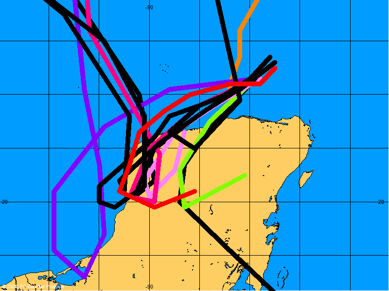


Tropical Storm Public Advisory
Statement as of 5:00 am EDT on August 27, 2008
...Gustav stalls...heavy rain squalls over Haiti...
At 5 am...0900 UTC...the Hurricane Warning for Haiti from the
Dominican Republic-Haiti border westward to Le Mole St Nicholas has
been changed to a Tropical Storm Warning. A Tropical Storm Warning
is now in effect for Haiti from the Dominican Republic-Haiti border
westward to Le Mole St Nicholas. A Tropical Storm Warning means
that tropical storm conditions are expected within the warning area
within the next 24 hours.
At 5 am...the Hurricane Watch for Haiti from Le Mole St Nicholas to
the northern Haiti/Dominican Republic border has been changed to a
tropical storm watch. A tropical storm watch is now in effect for
Haiti from Le Mole St Nicholas to the northern Haiti/Dominican
Republic border. A tropical storm watch means that tropical storm
conditions are possible within the watch area...generally within 36
hours.
At 5 am...the government of Jamaica has issued a Tropical Storm
Warning for Jamaica. A Hurricane Watch and a Tropical Storm
Warning are now in effect for Jamaica.
A Hurricane Warning remains in effect for Cuba for the provinces of
Guantanamo...Santiago de Cuba...and Granma.
A Hurricane Watch remains in effect for the Cuban provinces of Las
Tunas and Holguin and all of the Cayman Islands.
Interests in central and western Cuba should closely monitor the
progress of Gustav.
For storm information specific to your area...including possible
inland watches and warnings...please monitor products issued
by your local weather office.
At 500 am EDT...0900z...the center of Tropical Storm Gustav was
located near latitude 18.6 north...longitude 73.5 west or about 80
miles...125 km...west of Port au Prince Haiti and about 155 miles...
250 km...southeast of Guantanamo Cuba.
Gustav has not moved much during the past few hours...but is
expected to resume a motion toward the west-northwest near 5
mph...7 km/hr soon. A west-northwest to west track is forecast
during the next day or two with a gradual increase in forward
speed. On the forecast track...Gustav should pass between Jamaica
and the southeastern coast of Cuba on Thursday.
Maximum sustained winds remain near 60 mph...95 km/hr...with higher
gusts. Slow strengthening is forecast and Gustav could regain
hurricane strength on Thursday once it moves away from Haiti.
Tropical storm force winds extend outward up to 50 miles...85 km
from the center.
The latest central pressure as estimated from an Air Force Reserve
reconnaissance plane is 998 mb...29.47 inches.
Gustav is expected to produce total rainfall accumulations of 6 to
12 inches over Hispaniola...eastern Cuba...Jamaica...and the Cayman
Islands...with isolated maximum amounts of up to 25 inches
possible. These rains will likely produce life-threatening flash
floods and mud slides.
Coastal storm surge flooding of 1 to 3 feet above normal tide levels
along with large and dangerous battering waves can be expected in
areas of onshore winds.
Repeating the 500 am EDT position...18.6 N...73.5 W. Movement
toward...west-northwest near 5 mph. Maximum sustained winds...60
mph. Minimum central pressure...998 mb.
An intermediate advisory will be issued by the National Hurricane
Center at 800 am EDT followed by the next complete advisory at 1100
am EDT.
$$
Forecaster Blake/Avila
Tropical Storm Gustav Discussion Number 9
Statement as of 5:00 am EDT on August 27, 2008
Gustav has been hugging the north coast of southwestern Haiti this
morning with strong bands of thunderstorms to the east and south of
the center. An Air Force Reserve reconnaissance plane found a
minimum pressure of 998 mb and reliable SFMR winds of 45-50 kt. The
initial intensity will be set at 50 kt. Little intensification is
foreseen until the center moves farther away from the high terrain
of Haiti. Thereafter...a steady increase in strength is likely...
especially after the center moves into the more open waters
northwest of Jamaica. Vertical shear is forecast to be light...and
combined with the deep warm waters...rapid intensification could
occur in a couple of days while the center is near or south of
western Cuba. The official forecast is reduced from earlier due to
the initial weakening but still shows the storm becoming a major
hurricane in the northwestern Caribbean Sea. In the longer-term...
the global models have a variety of upper-wind patterns...but in
general the upper winds appear to be favorable enough to support a
major hurricane in the Gulf of Mexico. It should be noted that
both the GFDL and HWRF are more aggressive than the official
forecast.
The storm has not been moving much recently but an averaged over the
past twelve hours yields an estimate of 300/4. A turn toward the
west is likely today as the storm bumps into a large high pressure
ridge over the Bahamas and Florida. Gustav should then be steered
around the southern periphery of the high for the next several days
and turn northwestward in the Gulf of Mexico. The official forecast
is very close the previous one and is just to the left of the model
consensus. The GFS is an extreme outlier early on...taking the
storm near the north coast of Cuba...which is considered very
unlikely at this time.
Forecast positions and Max winds
initial 27/0900z 18.6n 73.5w 50 kt
12hr VT 27/1800z 19.0n 74.3w 50 kt
24hr VT 28/0600z 19.1n 75.6w 60 kt
36hr VT 28/1800z 19.2n 77.2w 70 kt
48hr VT 29/0600z 19.6n 78.8w 80 kt
72hr VT 30/0600z 21.0n 82.5w 100 kt
96hr VT 31/0600z 23.5n 86.0w 105 kt
120hr VT 01/0600z 27.0n 89.5w 105 kt
$$
forecaster Blake/Avila
I was sickened last night listening to James Carville and the CNN libs as they drooled at the possibility a killer hurricane might strike NOLA during the RNC Convention this year. They even called it “a political hurricane” that would cut into national coverage of the Repub. Convention. No conscience, no shame.
The psyches of the silly.
Disclaimer: Opinions posted on Free Republic are those of the individual posters and do not necessarily represent the opinion of Free Republic or its management. All materials posted herein are protected by copyright law and the exemption for fair use of copyrighted works.