Skip to comments.
2,000-Year-Old Stonemason's Tools Discovered in Romanian Quarry
Archaeology Magazine ^
| May 12, 2025
| editors / unattributed
Posted on 05/20/2025 2:11:11 PM PDT by SunkenCiv
Almost 2,000 years ago, a stonemason working in a limestone quarry near the hill of Mǎgura Cǎlanului in current-day Romania left behind his tools. A local resident happened upon the corroded bits of metal in 2022 and brought them to the attention of the Corvin Castle Museum in Hunedoara, according to a La Brújula Verde report. The artifacts turned out to be a complete stonemasonry toolkit, the first of its kind ever found in pre-Roman Dacia and one of the most complete kits from anywhere in Europe. The set consists of 15 different objects weighing a total of 25 pounds, including double-headed picks, chisels, pointers, and wedges that were used at various times to cut, shape, and refine stone blocks. It also includes a special hammer and a small anvil that the stonesmith could have used to sharpen his tools onsite. Although certain pieces show clear Roman influences, historian Aurora Pețan of West University of Timişoara believes that the tool set belonged to a pre-Roman Dacian stonemason. Her report stated that the discovery at Măgura Călanului deepens scholarly understanding of stonemasonry in Dacia and calls into question previous hypotheses about quarry construction and exploitation in the region. The worker may have hidden his tools to keep them safe during a time of crisis, Pețan posited, perhaps due to the Roman conquest of Dacia in a.d. 102. Alternatively, he may have also simply stored his gear at the quarry to avoid lugging the tools back and forth daily and for some reason wasn't able to return and retrieve them. Read the original scholarly article about this research in Prachistorische Zeitschrift.
(Excerpt) Read more at archaeology.org ...
TOPICS: History; Science; Travel
KEYWORDS: dacia; godsgravesglyphs; limestone; maguracalanului; quarry; romanempire; romania; stonemason
Navigation: use the links below to view more comments.
first previous 1-20, 21-32 last
To: SunkenCiv
You’ll put your eye out with that Harbor Freight tool! Don’t say I didn’t warn you!
21
posted on
05/20/2025 5:52:08 PM PDT
by
HandyDandy
(“Borders, language and culture.” Michael Savage)
To: SunkenCiv
World War II–era surveillance satellite images,We had satellites in WWII?
22
posted on
05/20/2025 6:01:23 PM PDT
by
ladyjane
To: ladyjane
Actual quote from archeology.org:
“Half the archaeological sites discovered in Britain over the last 70 years were found via aerial photography. Archaeologists continue to dig through World War II reconnaissance and recently declassified U.S. surveillance satellite photographs to uncover new ones.”
23
posted on
05/20/2025 6:10:14 PM PDT
by
jjotto
( Blessed are You LORD, who crushes enemies and subdues the wicked.)
To: ladyjane
That one got by their editor, and I didn’t read it closely.
The first photo from space was taken in 1946 by the US using a souped up V2.
24
posted on
05/20/2025 6:13:58 PM PDT
by
SunkenCiv
(Putin should skip ahead to where he kills himself in the bunker.)
To: SunkenCiv; jjotto
I began to get really interested that we had satellites and remote sensing back then. If only we had, the world might be different.
25
posted on
05/20/2025 6:16:53 PM PDT
by
ladyjane
Spying the Past from the Sky | Nikhil Swaminathan
Digs & Discoveries | Archaeology Magazine | November/December 2013
Half the archaeological sites discovered in Britain over the last 70 years were found via aerial photography. Archaeologists continue to dig through World War II reconnaissance and recently declassified U.S. surveillance satellite photographs to uncover new ones.
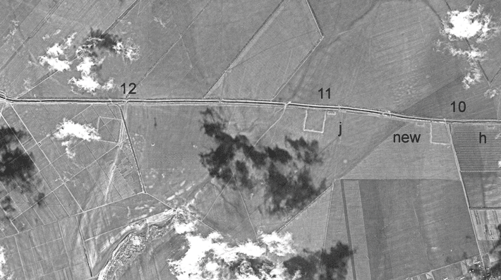
William Hanson of the University of Glasgow and Ioana Oltean of the University of Exeter have brought this technique to the eastern Romanian region of Dobrogea, studying 1960s photographs of the area. They noticed three distinct, overlapping fortifications stretching over 38 miles -- two of earthwork and one of stone -- with more than 30 forts attached. The structure of the barriers is similar to that of Hadrian’s Wall in England. The team suggests the fortifications could date to the second century A.D., when they might have been the Roman Empire’s easternmost frontier defenses.
"This photography shows the landscape as it was before the destructive impact of later twentieth-century development," Hanson explains, adding that such photography of the Middle East is also available. "The potential to change our understanding of the historical landscape in such areas is considerable."Photo: Stanley Guenter, Courtesy U.S. Geological Survey
26
posted on
05/20/2025 6:21:13 PM PDT
by
SunkenCiv
(Putin should skip ahead to where he kills himself in the bunker.)
To: 9YearLurker
He never came back for them because he got lost on the way to the can.
BTW, this guy’s nickname was Chip.
27
posted on
05/20/2025 6:24:27 PM PDT
by
SunkenCiv
(Putin should skip ahead to where he kills himself in the bunker.)
To: ladyjane
When I was in high school I saw a ground pic of a pretty cool aerial photo test using a rapid strobe for nighttime spy missions. The test was a perfectly illuminated Stonehenge.
Oh, no ****:
[Brave AI]
Stonehenge Strobe Photo
During World War II, Harold Edgerton, a famous photographer and MIT professor, was asked to develop a new photographic technique for the British military. This technique involved using a high-power strobe light attached to a bomber to illuminate Stonehenge from above, similar to the drone techniques used by modern photographers like Reuben Wu.
Edgerton’s work was crucial for aerial reconnaissance at night, and he tested his system in the area around Stonehenge a few weeks before D-Day to ensure that the timing for the Normandy landings was correct.
The images captured confirmed that the Germans had not amassed extra forces in Normandy at night, which was vital for the success of the operation.
Additionally, a collection of aerial photographs taken during World War II by the US Army Air Forces Photographic Reconnaissance units has been made available to the public. These images include a photo taken on Christmas Eve in 1943 of Stonehenge, which shows markings highlighting the location of a First World War aerodrome and camp.
AI-generated answer. Please verify critical facts.
https://ru.pinterest.com/pin/536209899357611868/
28
posted on
05/20/2025 6:29:44 PM PDT
by
SunkenCiv
(Putin should skip ahead to where he kills himself in the bunker.)
29
posted on
05/20/2025 6:32:48 PM PDT
by
SunkenCiv
(Putin should skip ahead to where he kills himself in the bunker.)
To: HandyDandy
No problem, I bought a bag of replacement eyes over from aisle six.
30
posted on
05/20/2025 6:34:04 PM PDT
by
SunkenCiv
(Putin should skip ahead to where he kills himself in the bunker.)
31
posted on
05/20/2025 11:21:42 PM PDT
by
SunkenCiv
(Putin should skip ahead to where he kills himself in the bunker.)
To: SunkenCiv
F-ing Mario Maxamus Rossi, never returns tools he borrows...
32
posted on
05/21/2025 5:28:50 AM PDT
by
BFW
(loss of signal)
Navigation: use the links below to view more comments.
first previous 1-20, 21-32 last
Disclaimer:
Opinions posted on Free Republic are those of the individual
posters and do not necessarily represent the opinion of Free Republic or its
management. All materials posted herein are protected by copyright law and the
exemption for fair use of copyrighted works.
FreeRepublic.com is powered by software copyright 2000-2008 John Robinson