What an incredible dataset to look at.
Posted on 12/18/2024 6:09:03 PM PST by Tom Tetroxide
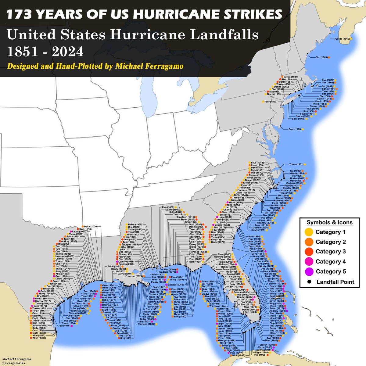
It's finally done. Over 3 days of hand-plotting 173 years' worth of data. The end result is unbelievable.
What an incredible dataset to look at.
“Yes, due to the earth’s rotation. Same reason why weather fronts in general go from west to east.”
Hurricanes are driven by prevailing winds.
Prevailing winds are driven by the earth’s rotation and local high and low pressure areas.
Something even more challenging would be to trace the track of each one….
“WE’RE GONNA NEED A BIGGER MAP!!”
“Hurricane sandy in 2012 found that gap but it lost its tropical characteristics by the time it hit southern NJ so it’s referred to as a Superstorm sandy”
Thanks. I notice the 2nd landfall for Agnes in 1972 was not listed. I guess because it was “only” a tropical storm by then, though it caused many deaths and huge damage.
West winds
Great stuff, Buddy!
How do they all end at the border of Texas and Mexico?
WW don’t save Long Island....
Delaware most certainly has state income and real etate taxes. but n retail sales taxes. Buy a car, and you’re taxed on that purchase.
My father was a geology major in college, so when he retired he bought the US Geologic Survey earthquake maps, trying to stay far away from southern California's many earthquake faults. He settled on Oceanside, halfway between LA and SD.
According to the map, quite a few have hit Hartford, Conn. I don't see any making landfall in Hampshire, Ill., although Sandy paid a visit in 2012. Hereford, Texas is probably west of the hurricane belt, but it gets tornados.
Delmarva AND New Jersey.
That is really remarkable, isn’t it? How in the world do hurricanes know about our state borders?
“but n retail sales taxes”
It is buried in the price. Vendor is taxed via grossed receipts tax.
‘Rats are repulsive when in large concentrations?
US strikes, that’s why.
“According to the map, quite a few have hit Hartford, Conn.”
None are shown hitting Hartford. It only shows landfall and Hartford is not on the coast.
boy..if they ever get a cat 5 at just the right angle, just North of the mouth of the Mississippi River....New Orleans will be gone. Only a matter of time.
I guess no place is safe.
Wasn’t aware of that aspect. Thanks for bringing that out.
well done
Why not use something like Tableau or another type map program,
Disclaimer: Opinions posted on Free Republic are those of the individual posters and do not necessarily represent the opinion of Free Republic or its management. All materials posted herein are protected by copyright law and the exemption for fair use of copyrighted works.