Posted on 09/28/2022 11:24:51 AM PDT by Red Badger
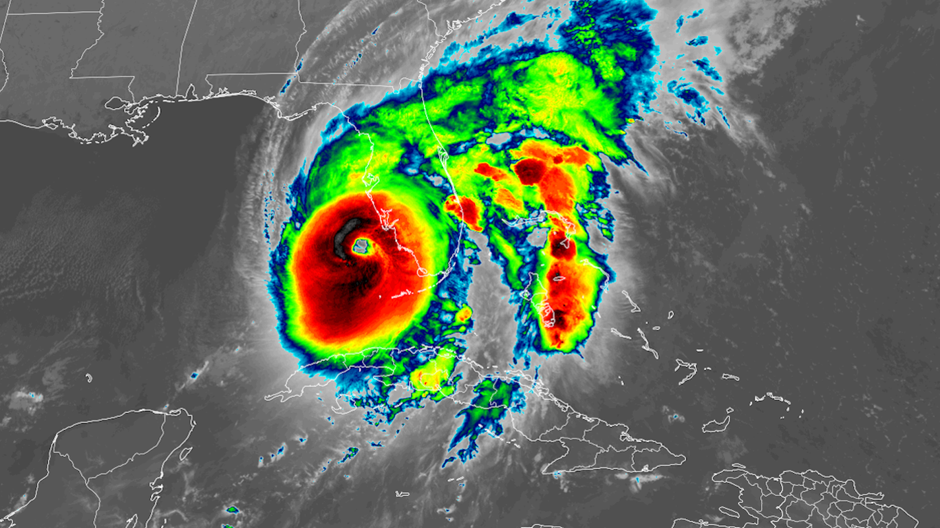
Hurricane Ian satellite photo Image: NOAA
An intensifying Hurricane Ian is on the cusp of becoming a Category 5 storm as it nears landfall along Florida's west coast with "catastrophic" winds and storm surge flooding Wednesday afternoon, per the National Hurricane Center.
State of play: The Category 4 hurricane is packing maximum sustained winds of 155 mph, the NHC said. That's just 2 mph shy of Category 5 intensity.
Just four hurricanes have made landfall in the U.S. with maximum sustained winds greater than 155 mph, according to Philip Klotzbach, a researcher at Colorado State University.
As of 1pm Wednesday, the center of Hurricane Ian was located 45 miles west-southwest of Punta Gorda, Florida, and was moving north-northeast at 9 mph, packing 155 mph winds.
The major storm unleashed life-threatening storm surge flooding across the lower Florida Keys overnight. It's doing the same on the Florida mainland — including the highest surge levels on record in Naples, Florida. Ft. Myers, Sanibel Island and Cape Coral were also seeing damaging flooding as of midday. Water has pushed inland in some communities.
The Hurricane Center increased storm surge forecasts Wednesday morning to as high as 18 feet in parts of southwest Florida, including Charlotte Harbor and Bonita Beach.
This would be unprecedented there, and on par with some of the country's highest surge events in history. What they're saying: Florida Gov. Ron DeSantis said at a briefing Wednesday morning that Ian is "a major, major storm. ... The strengthening of this over the last night has been really, really significant."
MAP AT LINK..........
Data: National Hurricane Center; Map: Jared Whalen/Axios
What to expect: The center of Ian is expected to move across the west coast of Florida during early afternoon, then cross central Florida through Thursday morning and reemerge over water northeast of Florida by Thursday morning.
Hurricane-force winds are possible along the east-central Florida coast, the NHC stated.
Potentially "catastrophic" flooding was forecast with widespread rainfall amounts of up to 18 inches across much of the state, per the National Weather Service.
The Weather Service has issued a rare "high risk" outlook for flash flooding for much of the state.
Power outages are starting to occur in the state, with more than 304,000 without electricity, according to PowerOutage.us. That number is expected to rise.
More than 2,000 flights into, within or out of the U.S. were canceled as of mid-morning Wednesday, according to flight tracking website FlightAware.
Tampa
The city is likely to see a far lower storm surge, on the order of 4 to 6 feet, than areas to the south, due to the storm's track.
Axios Local dispatch, via Ben Montgomery: The approaching storm and a falling tide began emptying the shallows of the Hillsborough River, Old Hillsborough Bay and parts of Upper Tampa Bay Wednesday morning.
Along Tampa's Bayshore Boulevard, the water had retreated from the seawall about 50 feet in places, like it did when Hurricane Irma streaked east of the region in 2017.
Flashback: Hurricane Ian was taking a path similar to that of Hurricane Charley in 2004, which caused $14 billion (in 2004 dollars) in damage. However, Ian is a far larger storm, bringing a greater surge and broader wind field.
Threat level
What we're watching: One of the biggest threats is storm surge flooding at the coast, which prompted mandatory evacuations in many areas.
A storm surge warning was in effect for a heavily populated stretch of coastline that includes Tampa Bay, Fort Myers, Naples, Port Charlotte, St. Petersburg and Sarasota.
The NHC called surge heights "potentially historic," and warned that certain locations may be "uninhabitable for an extended period."
Lightning strikes were observed in the thunderstorms surrounding the eye, a sign of continued intensification through landfall. Devastating wind damage is occurring where the core of the storm moves ashore and barrels inland.
Climate change-related sea level rise is making surge-related flooding more damaging.
Georgia
Storm surge watches, tropical storm watches and warnings, and hurricane watches have been issued extending up and down the east coast of Florida into Georgia and south Carolina.
This is due to the storm's expected track after Florida.
Climate change context
Context: Hurricane Ian has been rapidly intensifying over extremely warm sea surface temperatures straight through landfall.
Climate change favors more instances of rapidly intensifying storms such as Hurricane Ian, due to the combination of warming seas and a warmer atmosphere that can carry additional amounts of water vapor.
The bottom line: Florida is experiencing a historic storm that could cause billions in damage.
Editor's note: This is a developing story. Please check back for updates throughout the day.
“The Category 4 hurricane is packing maximum sustained winds of 155 mph, the NHC said.”
.
I’m looking all over Windy.com and the fastest I can find is right at 100 mph and that is out to sea.
On the coast it is showing 77 mph.
I wonder why is there such a big difference?
.
Where’s your home?
Cuz that is at 10,000’. It makes for better headlines and such.
Yes and the news stations hype this stuff to death. I’m originally from Jacksonville and have been through 3-4 hurricanes. When I was a kid Dora slammed through with 120 mph winds and that was scary. Nobody was out in the street. 😉
“”Cuz that is at 10,000’. It makes for better headlines and such.””
Oh. Weather porn. Gotcha.
.
Traffic.........................
My house is in Nokomis, FL, and I hope it stays there.
My neighbor says her cousin’s house had three trees fall on it. Her nephew says it is ruined. The cousin is uninsured.
Yea, you are a little too close for comfort.
You’re weather dude was in the wrong spot. This is a very destructive storm already, and it isn’t even closed to finished. Port Charlotte/Ft. Myers area is going to need a lot of reconstruction. I’m sure other places will as well.
I thought Florida required people in certain areas to have insurance (?)
Hold on—Everyone with a start date of 2000 or thereabouts appears to be exhorting posters to re-direct their comments to NN’s hurricane thread, comments they have posted on all other storm threads, since yesterday morning. There are “ads” for NN’s thread all over the alternate threads. Why are their many amongst us who will not permit any storm thread which even hints at governmental or media manipulation of the facts on the ground to stand, and are actively attempting to hijack those threads? And not a peep from mods or administrator about any of this. So what makes NN’s thread so special that so many “veteran” FReepers are willing to eat their own just to grant exclusivity rights to one solitary poster?
Must be a Democrat thing.
That’s nuts. NN is well-known here for doing hurricane threads, but other people start them too.
I just didn’t see hers before I landed here.
Hey, something not blamed on Trump. So far.
For sure. At least a few days. We encountered zero traffic, we left at 5am this morning. Rained a good bit for the first hour and a half, then clear skies but windy. We’re staying in Atlanta at our other house for probably 4 days.
They’re saving their powder for Gov. DeSantis. As someone else posted, the negative articles and tweets are probably already prepared.
FIRST THREAD is the ‘OFFICIAL THREAT’.
That is usually the rule of thumb. What is it you want to say that can’t be said on the other thread?
4runner is just trying to cause trouble and get attention.
He/She doesn’t accept that the people alerting others to NN’s thread are doing simply that - alerting. Many people rely on her storm threads for good information; but that doesn’t mean it must be the ONLY one.
Also, one is posted in News, days ago; and this one in Chat today.
I’m not sure what 4runner means by ‘eating our own’ - unless it IS just trouble-causing. I’m not aware of anyone getting paid for posting here (most of us pay in appreciation for the privilege!) and therefore able to be ‘done out’ of anything.
Has anybody seen 155mph sustained winds yet?
I think that the core of the ‘cane was near cat-4 intensity just off the coast then dropped to a high cat-2 when the eye was over the bay (Charlotte Harbor). These maximum wind speeds are restricted to the eyewall and if no weather station is in the eyewall then you get reports from nearby locations that seem too low, but they are getting what was expected for them.
That being said, this hurricane’s worst impacts are storm surge rather than wind damage. Storm surge has been very high from about Venice to Naples. There will be some reports of wind damage eventually, but that weakening trend has probably reduced the wind potential from catastrophic to moderate especially once past the outer barrier islands.
When Charley came into the same area in 2004, it was a tighter circulation moving at a faster forward speed, which allowed the cat-4 winds of the eyewall to be maintained beyond landfall around Punta Gorda. This one is moving slower and has a flabbier inner core. I don’t doubt that there were cat-4 wind gusts near the surface over the Gulf just before landfall but then the weakening trend took over.
Disclaimer: Opinions posted on Free Republic are those of the individual posters and do not necessarily represent the opinion of Free Republic or its management. All materials posted herein are protected by copyright law and the exemption for fair use of copyrighted works.