Hailed as one of the top archaeological finds of 2015, the discovery added 12 percent to the total of known ancient shipwrecks in Greek territorial waters in just 10 diving days. 17th-Century Caribbean Shipwreck Explored: Photos V. Mentogianis
Posted on 10/29/2015 3:22:11 PM PDT by SunkenCiv
Hailed as one of the top archaeological finds of 2015, the discovery was made by a joint Greek-American archaeological expedition in the small Fourni archipelago with an area of just 17 square miles. This is a collection of 13 islands and islets located between the eastern Aegean islands of Samos and Icaria.
"Surpassing all expectations, over only 13 days we added 12 percent to the total of known ancient shipwrecks in Greek territorial waters," Peter Campbell, of the University of Southampton and co-director from US based RPM Nautical Foundation, told Discovery News.
Fourni lies right in the middle of the major east-west crossing route, as well as the north-south route that connected the Aegean to the Levant. Ships traveling from the Greek mainland to Asia Minor, or ships leaving the Aegean for the Levant had to pass by Fourni.
"Ikaria and the west coast of Samos have no harbors or anchorages, so Fourni is the safest place that ships could stop in the area," Campbell said.
It was the first time that an underwater archaeological expedition was organized to the islands. Archaeologists from the Greek Ephorate of Underwater Antiquities and RPM Nautical Foundation worked with local sponge divers, fishermen, and free divers, and were more than surprised by the results.
Funding was provided by the Honor Frost Foundation, a UK charity that supports research in the eastern Mediterranean through an endowment from pioneer maritime archaeologist Honor Frost.
"In a typical survey we locate four or five shipwrecks per season in the best cases," Greek director George Koutsouflakis said.
"We expected a successful season, but no one was prepared for this. Shipwrecks were found literally everywhere."
(Excerpt) Read more at news.discovery.com ...
Hailed as one of the top archaeological finds of 2015, the discovery added 12 percent to the total of known ancient shipwrecks in Greek territorial waters in just 10 diving days. 17th-Century Caribbean Shipwreck Explored: Photos V. Mentogianis
Thanks Carry_Okie.
That’s where the sirens were. VERY distracting...
All Muzzies I hope.
This reminds me of the old Hitchcock movie, Jamaica Inn, where the lighthouse was turned off with a decoy light in another spot to cause shipwrecks.
Jeb’s campaign may be down there as well.
along with his hopes and dreams :)
The bottom must be littered with Freeper firearms.
(Someone was going to say it eventually)
“The Sea Remembers” “Throck” would appreciate this!
Are they crazy?
Thats seriously impressive.
Just as a side thought: Think about how many things down with Davey Jones the USN has mapped fully over the years but remain classified because of unrelated issues (mission they were on/Depth/area etc.
All I admit to is ..... YES!
;)
“Fourni is the safest place that ships could stop in the area,”
With twenty two ship wrecks it does not sound like the safest. But then maybe that is 22 shipwrecks in 3000 years.

is right in the passage between between the Greek islands of Samos and Ikaria (a great place to cause shipwrecks), and, is in a very historic region:
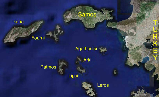
Fourni is just 20 miles north of the island of Patmos , where John, the Disciple was exiled when he wrote the book of Revelation.
And, Samos, of course, was the home of Pythagoras of Samos -- of right triangle hypotenuse fame...
Huh. I wonder if there was a local economy based on insurance scams.
Just envision the currents roaring through the pass between Ikaria and Samos -- and imagine the challenge of trying to miss all those Fournoi obstacles with a primitive sailing / rowed vessel!
Did they find the Greek economy down there too?


Right down the drain.
Disclaimer: Opinions posted on Free Republic are those of the individual posters and do not necessarily represent the opinion of Free Republic or its management. All materials posted herein are protected by copyright law and the exemption for fair use of copyrighted works.

