Posted on 12/29/2007 8:01:23 PM PST by SunkenCiv
Mark Borda and Mahmoud Marai, from Malta and Egypt respectively, were surveying a field of boulders on the flanks of a hill deep in the Libyan desert some 700 kilometres west of the Nile Valley when engravings on a large rock consisting of hieroglyphic writing, Pharaonic cartouche, an image of the king and other Pharaonic iconography came into view. Mr Borda would not reveal the precise location in order to protect the site... "The consensus among Egyptologists is that the Egyptians did not penetrate this desert any further than the area around Djedefre's Water Mountain. This is a sandstone hill about 80 kilometres south west of the Dakhla Oasis that contains hieroglyphic inscriptions. Its discovery in 2003 by the German explorer Carlo Bergmann caused a sensation as it extended the activities of the Pharaonic administrations an unprecedented 80 kilometres further out into the unknown and waterless Western Desert. The find we just made is some 650 kilometres further on!! Egyptologists will be dumbstruck by this news." ...Maltese Egyptologist Aloisia De Trafford from the Institute of Archaeology (University College London)... facilitated a preliminary decipherment of the text via Joe Clayton, an ancient languages specialist who lectures on hieroglyphic writing at Birkbeck College at the same university... "It turns out that the script we found states the name of the region where it was carved, which is none other than the fabled land of Yam, one of the most famous and mysterious nations that the Egyptians had traded with in Old Kingdom times; a source of precious tropical woods and ivory. Its location has been debated by Egyptologists for over 150 years but it was never imagined it could be 700 kilometres west of the Nile in the middle of the Sahara desert."
(Excerpt) Read more at independent.com.mt ...
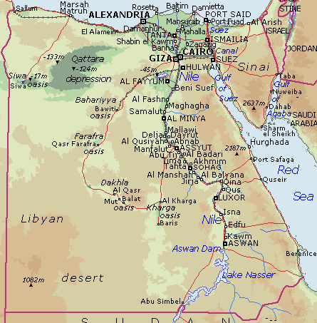
nice little map of the vicinity of Dakhla Oasis:
http://touregypt.net/Map25.htm
comes from here:
http://touregypt.net/dakhla5.htm
asswan tomb of Herkuf Mekhu SabniThe tomb dates from dynasty VI during the reigns of Merenre and Pepi II... the vast body of texts, which decorate the external facade... "His Majesty Merenre, my master, sent me, together with my father, Sole Companion end Lector-Priest, Iri to the land of Yam... I carried out this mission in seven months... His Majesty sent me a second time, alone. I went by way of the Elephantine road and returned via the land of Irtet, Makher and Teres of Irtet at the end of a voyage of eight months... I returned, coming from the camp of the chief of Setu and Irtet after having explored this land. You will find no other Sole Companion, Chief of interpreters who has reached (so far) into the land of Yam before. His Majesty sent me for a third time to the land of Yam. I went there from the Nome of Thinis by the oasis road and I observed that the chief of the land of Yam had left for the land of the Timhiu to chastise them, as far as the western corner of the sky. I followed his trail to the land of the Timhiu and I pacified him until he adored all the gods for the sake of the royal Sovereign... (I shall make haste... with a man from the land of Yam)... so thet His Majesty Merenre, my royal Lord, shall know (that I went to the land of Timhu) following the chief of the land of Yam. After having given satisfaction to this celebrated chief, (I returned via ...) the south of the land of Irtet, the north of Setu and I met the chief of Irtet-Setu-WaWat... I returned with three hundred donkeys burdened with incense, ebony, hekenu perfume, grain, panther skins, elephant tusks, many boomerangs, all kinds of beautiful and good presents. When the chief of Irtet-Setu-WaWat saw how strong and numerous were the troops of the land of Yam returning with me towards the residence (marching) in the company of the army which had been sent with me, he handed over, to be given to me, bulls and goats and guided me through the ways of the hills of Irtet- because of the skill and the vigilance which I had shown, more than any other Companion, Chief of interpreters, former envoy to the land of Yam. Then, this servant followed the course of the river as far as the Residence; and it was arranged that the prince, Sole Companion, Steward of the two halls of libation (?) came to meet me with ships loaded with date wine, cakes, bread and beer." ...A fourth, unnarrated, campaign to the land of Yam must have taken place, during which Harkhuf sent a letter to the young king Pepi II to inform him, particularly, that he was bringing back a pygmy, which resulted in the rest of the inscription... Pepi II wrote a letter in reply to that of Harkhuf, who... had the text inscribed on the facade of his tomb... Thus, the only complete royal letter dating from the old Kingdom has reached us.
from Claire Lalouette:
Sacred and secular texts from ancient Egypt
Gallimard, 1984
translation by Jim Ashton
Nigeria’s ‘land of twins’ baffles fertility experts
Nov 11, 2007
http://afp.google.com/article/ALeqM5i_IsZNBK7Hf1B4VhfWtFxg7G2svw
...Yam consumption may be one explanation for Africa’s largesse, some West Africans and Western experts believe. Yams contain a natural hormone phytoestrogen which may stimulate the ovaries to produce an egg from each side.
Happy and Blessed New Year’s wish for you also SunkenCiv and all Freepers.
Thanks DB, and also to you and yours.
Nah, that was small potatoes—but thanks for the thought.
Hope you have a great New Year planned.
Too late, Just watched episode 1 of Stargate Yam, “The Thanksgiving.”
I find that my years go pretty much not according to my plan, so I try not to plan, that way I’m not disappointed. ;’) HNY!
one of probably several for this:
Huge Crater Found in Egypt - Kebira
Space.com | 3/3/06 | Robert Roy Britt
Posted on 03/03/2006 11:58:45 PM EST by NormsRevenge
http://www.freerepublic.com/focus/f-news/1589775/posts
The Nubian Aquifer in Southwest EgyptAbstract: Synthetic Aperture Radar (SAR) images, and topographic and groundwater data are used to understand heterogeneities of the Nubian Aquifer between 20-24.5°N and 25-32°E in southwest Egypt. New fluvial and structural interpretations emphasize that the desert landscape was produced by fluvial action, including newly mapped alluvial fans. In central locations, braided channels are spatially aligned with a NE structural trend, suggesting preferential water flow paths that are consistent with the local direction of groundwater flow. The alluvial fans and structurally enclosed channels coincide with gentle slopes and optimal recharge conditions (1-5%) derived from the new Shuttle Radar Topographic Mission (SRTM) slope map, indicating that these areas have high groundwater potential. The SAR interpretations are correlated with anomalies observed in groundwater data from 383 wells. Results suggest a relationship between the spatial organization of fluvial and structural features and the occurrence of low-salinity groundwater. Low-salinity water exists adjacent to the alluvial fans and in SW reaches of the structurally enclosed channels. Wells in the vicinity of structures contain low-salinity water, emphasizing that knowledge of structural features is essential to understand groundwater flow paths. The new approach is cost effective and noninvasive and can be applied throughout the eastern Sahara to assist in resource management decisions and support the much needed agricultural expansion.
C. A. Robinson, A. Werwer,
F. El-Baz, M. El-Shazly,
T. Fritch, and T. Kusky
“The Oasis road led from the Thinite nome to Kharga Oasis and from there it passed along the Darb el-Arbain (forty-day trail) to Selima.”
Thinis: History & Locale
http://www.thinis.com/thinis/index.html
Nomes map:
http://www.touregypt.net/featurestories/nomemap1.jpg
Picture of Selima:
http://proteus.brown.edu/odell/admin/image.html?imageid=2925828
It’s the stuff dreams are made of.
Then ask The Bangles.
...the real experts.
This topic was posted , this is just a bit of an update.
The biggest desert discovery of the decade | February 11th, 2010 | The Explorer School (via the Wayback Machine)Mark Borda and Mahmoud Marai made arguably the biggest Eastern Sahara discovery of the decade when they found the ancient Egyptian inscriptions on a large boulder right in the Sudan/Egypt/Libyan border area. Here, Mark Borda answers a few questions on the matter...
5. Who has identified the inscription and what does it read?
The inscription has not yet been seen in situ by any archaeologists or Egyptologists. It was first translated and interpreted by means of examining photographs by Egyptologist Aloisia De Trafford of University College London and ancient language specialist Joseph Clayton of Birkbeck College, University College, London.
It reads as follows:Son of Ra, MentuhotepA singular feature about this inscription in comparison to other Yam inscriptions is that it records a meeting between Egyptians and Yamites at the actual geographical point where the meeting took place. It's very difficult to explain why two peoples both living on or relatively near to the Nile would choose to meet at such an inordinately distant spot west of the river, involving both peoples in a round trip of over 1200 kilometers (straight line distance only) through one of the worlds harshest and most impassable terrains.
Above the cartouche and slightly to the right we find the king's nsw-bity title, which can be translated as 'king of the dualities' or ' King of Upper and Lower Egypt.'
Horus living forever
Upper couplet
Yam bringing incense
Tekhebet bringing ..
The inscription is therefore raising serious questions not only about the true location of Yam but it is also bringing closer into the realm of the possible, a series of other startling propositions that would previously have been in the domain of the virtually unthinkable. One is the possibility that Uweinat was not the final destination of the Egyptians south western travels and that indeed they may have ventured much further into subtropical zones in the heart of Africa.
Tibesti-Jebel Uweinat Montane Xeric Woodlands | UNEP-WCMC Author Team | First published: September 23, 2020The Tibesti-Jebel Uweinat Montane Xeric Woodlands contain the highest mountain of the Sahara, Emi Koussi at 3,415 m. Both Tibesti and Jebel Uweinat have beautiful rock art, recording the animal and human life of the area, carved in caves and on outcrops over 7,000 years ago. A refuge for relict Mediterranean flora, with cooler temperatures and higher rainfall compared to the surrounding desert, the ecoregion provides a haven for aoudad, Dorcas gazelle, jackals, foxes, rock hyrax, Egyptian vultures, sand grouse, and greater hoopoe-larks. The permanent rockpools of Tibesti support eight endemic relict fish species...
Tibesti has permanent pools (gueltas) found among ravines, and seasonal watercourses (wadis), which flow following rain. The mountains are an important refuge for relict Mediterranean flora such as the endemic Nivelle myrtle. Doum palm, toothbrush tree, apple-ring acacia, Tamarix articulata, and Acacia nilotica adstringens grow along wadis, while gueltas also support date palms. Nivelle myrtle, wonderboom tree, and highly poisonous oleander are found on the mountain slopes. Jebel Uweinat has sparse amounts of Salvia and Lavandula on peaks and umbrella thorn acacia, Fagonia indica, and kapok at lower altitudes... The presence of permanent water means Tibesti supports eight endemic relict fish species of Central Sahara...
A number of species previously reported are now believed to be absent, including addax, dama gazelle, cheetah, and ostrich. The biodiversity and species richness of the region, particularly in the Tibesti mountains, are currently not well documented. Only a small area of the ecoregion at Jebel Uweinat is part of a protected area: the southwestern tip of El-Gelf El-Keber National Park in Egypt.
Gebel Uweinat | Egypt, Africa | Lonely PlanetThe mountain Gebel Uweinat sits on the border of Egypt, Sudan and Libya. At 1934m, it is the highest point in Egypt. As it name in Arabic implies, there are eight small springs within the mountain, even though the mountain sits in the most inhospitable part of the Western Desert. The oasis was rediscovered by Ahmed Hassanein in 1923. It was off limits to foreigners at the time of writing.
Hassanein discovered thousands of petroglyphs on the sandstone rocks, including depictions of humans looking very much like the Nilotic peoples of today, as well as lions, giraffes, ostriches, gazelles and cows.
Disclaimer: Opinions posted on Free Republic are those of the individual posters and do not necessarily represent the opinion of Free Republic or its management. All materials posted herein are protected by copyright law and the exemption for fair use of copyrighted works.

