Skip to comments.
Magnitude 4.8 earthquake strikes northeastern United States
CNBC ^
| 4/5/24
Posted on 04/05/2024 8:13:38 AM PDT by EBH
A magnitude 4.8 earthquake shook the coast of the northeastern United States on Friday morning.
The earthquake was felt from Boston down to Baltimore, according to the U.S. Geological Survey.
Many incoming flights at major airports in and around New York City were being diverted from landing, according to the Federal Aviation Administration.
New York Gov. Kathy Hochul in a tweet said, “My team is assessing impacts and any damage that may have occurred, and we will update the public throughout the day.”
(Excerpt) Read more at cnbc.com ...
TOPICS: News/Current Events; US: New Jersey; US: New York
KEYWORDS: earthquake; globalwarming; newjersey
Navigation: use the links below to view more comments.
first previous 1-20, 21-40, 41-60, 61-73 last
To: KamperKen
61
posted on
04/05/2024 9:54:03 AM PDT
by
Political Junkie Too
( * LAAP = Left-wing Activist Agitprop Press (formerly known as the MSM))
To: EBH
Felt it in southern CT - first thought was nuclear detonation maybe south of NYC.
Glad it was only an earthquake.
62
posted on
04/05/2024 10:51:10 AM PDT
by
Psalm 73
("You'll never hear surf music again" - J. Hendrix)
To: janetjanet998
63
posted on
04/05/2024 10:55:26 AM PDT
by
Psalm 73
("You'll never hear surf music again" - J. Hendrix)
To: Bloody Sam Roberts
These morons sure like letting their mouths write checks that their fannies can’t cash.
Bad news morons: there is Someone Who will cash those checks and they will NOT like the payout.
Ezekiel 38 and 39
To: mikelets456
Somebody on patriots.win said it was Lizzo practicing her new DNC fundraiser dance routine.
65
posted on
04/05/2024 11:05:25 AM PDT
by
mass55th
(“Courage is being scared to death, but saddling up anyway.” ― John Wayne)
To: EBH
I live in the Mohawk Valley, Central NY State. Our local news website said it was felt here. I didn’t feel it, nor did my son.
66
posted on
04/05/2024 11:06:27 AM PDT
by
mass55th
(“Courage is being scared to death, but saddling up anyway.” ― John Wayne)
To: Forward the Light Brigade
"4.8 That’s nothing. In California that is a little shaker.
We've had those here a couple of times in Central NY State. Just a little movement, then looked at the lampshade across the room, and noticed it swaying. Didn't last long. Felt nothing here today.
67
posted on
04/05/2024 11:10:10 AM PDT
by
mass55th
(“Courage is being scared to death, but saddling up anyway.” ― John Wayne)
To: mass55th
To: EBH
I felt it in Baltimore. Took me a moment to realize it was an earthquake, but this is the third one I’ve felt over the last 22 years here. The whole house shook. The china in our china cabinet was shaking. My wife did not feel it but she was sewing at the time and was on the second floor. I immediately checked the USGS and it was already posted on their site.
69
posted on
04/05/2024 11:14:33 AM PDT
by
scouter
(As for me and my household... We will serve the LORD.)
To: caww; EBH
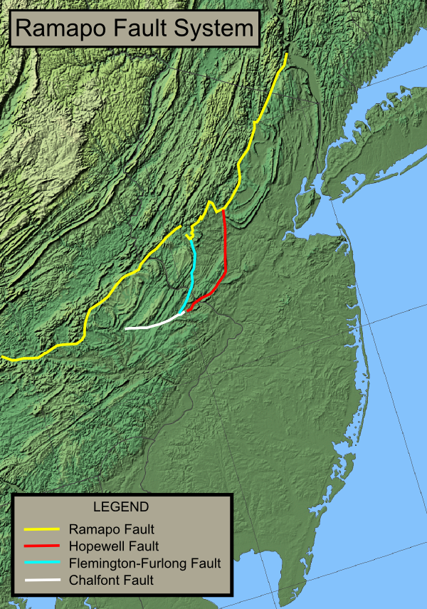
Ramapo Faulthttps://en.wikipedia.org/wiki/Ramapo_Fault"The Ramapo Fault zone is a system of faults between the northern Appalachian Mountains and Piedmont areas to the east.
Spanning more than 185 miles (298 km) in New York, New Jersey, and Pennsylvania, it is perhaps the best known fault zone in the Mid-Atlantic region, and some small earthquakes have been known to occur in its vicinity."
- Wikipedia
70
posted on
04/05/2024 11:16:27 AM PDT
by
linMcHlp
To: EBH; Red Badger
I scanned through this thread and didn’t see that anyone had noticed the anomalies in the USGS data/header for this EQ.
This info is in the midst of the article you linked:
“The epicenter of the quake was detected about 45 miles west of New York City, and 40 miles east of Allentown, Pennsylvania, in an area north of Whitehouse Station, New Jersey, according to the USGS.”
Here’s the USGS map with the EQ menu:
https://earthquake.usgs.gov/earthquakes/map/
There’s the normal title format (as seen throughout the listings):
Mag., distance from location (nearest town, when applicable)
date, time
lat/lon
depth
Then there’s this one:
M 4.8 - 2024 Whitehouse Station, New Jersey Earthquake
Time
2024-04-05 10:23:20 (UTC-04:00)
Location
40.703°N 74.758°W
Depth
4.7 km
https://earthquake.usgs.gov/earthquakes/eventpage/us7000ma74/executive
What’s 2024 doing in there? Or the word Earthquake in the title (department of redundancy)
And the depth: 4.7 km
And there’s no distance given to Whitehouse Station, as if the EQ is centered on the place.
It’s not even the closest reference point. Whitehouse Station is ~ 6 mi south, whereas Califon is ~ 4 mi a little north of west..
Just thought I’d point this stuff out.
71
posted on
04/05/2024 2:11:46 PM PDT
by
Ezekiel
(🆘️ "Come fly with US". 🔴 Ingenuity -- because the Son of David begins with MARS ♂️, aka every man)
To: rdl6989
"One of the biggest in NJ history."Interesting... because many of us didn't even notice the earthquake today, but we all remember feeling the one that happened in 2011.
To: EBH
73
posted on
04/19/2024 3:19:53 AM PDT
by
mewzilla
(Never give up; never surrender!)
Navigation: use the links below to view more comments.
first previous 1-20, 21-40, 41-60, 61-73 last
Disclaimer:
Opinions posted on Free Republic are those of the individual
posters and do not necessarily represent the opinion of Free Republic or its
management. All materials posted herein are protected by copyright law and the
exemption for fair use of copyrighted works.
FreeRepublic.com is powered by software copyright 2000-2008 John Robinson