Posted on 11/07/2022 2:18:20 AM PST by NautiNurse
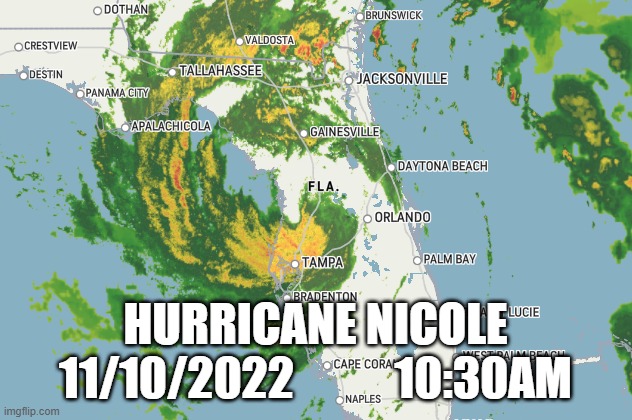
November brings Nicole and mid-term elections. Nicole has developed with subtropical characteristics in the Atlantic Ocean, taking aim for storm weary Florida.
A subtropical system has some central convection fairly near the center surrounding a warming core existing in the mid-levels of the troposphere. Nicole may further develop into a tropical storm.
Mash the graphics below to enlarge. All links and images are self-updating.
Tropical Tidbits by Levi Cowan
Local News Sources:
Miami Local10
NBC6 Miami/Ft Lauderdale
NBC5 WPTV Palm Beach
Great to hear your power is mostly working. The pup experience sounds adorable! Tried to reach Mom, no answer. Could be any number of innocuous reasons, like she didn’t get enough sleep last night. Or she’s in the bathroom. Ha!
I have one of those dogs. The other will go out in the middle of a hurricane.
Thank you for checking in. Wonderful news that you have electricity! Nighttime hurricanes are the worst.
Hope you fared ok! We’re all good. Still have power. Indian River is in the backyard but actually stops short of the house!
Skyway Bridge is closed with 50 MPH winds reported.
All good here in Port St Lucie! Glad you fared well and thanks for checking in!
Bands of heavy rain and wind gusts have been coming through Pinellas County for an hour or so. My doorbell camera keeps getting triggered by the movement of the palms and bushes in the front yard.
Thank you for your local report. Love the doorbell cam. Had a curious hummingbird staring into the camera one day.
Wind is shifting from the northwest to west and blowing stronger than earlier. I’m totally mesmerized.
North Palm/Juno did well. Beach issues that might deteriorate more with the seas.
Thank you for checking in. Good to hear your area fared well outside of beach erosion.

Tampa Bay = not as much rain as expected... well,not yet.
Hah! I don’t drive that bridge in 0 mph wind. We lived in Clearwater when the ship accident happened- I’ll never forget it. My husband often went to Sarasota on business and I went with him once after the accident way before the new bridge. Seeing the other span just end while driving so close, way up in the air just did me in. Chills just thinking about it.
Otherwise ok over there? Looked as though you were getting lots of rain.
Still very windy here, drizzly.
I'm hoping that the Artemis space rocket survives undamaged. They leaving it on the launch pad at Cape Canaveral.
Heard interesting info on the noon news. Hurricanes Charley and Jeanne in 2004 (like you would forget) occurred 43 days apart, their paths crossing in the middle of the peninsula.
Ian and Nicole also occurred 43 days apart this year, crossing paths very close to where Charley and Jeanne crossed years ago.
NASA leaves its Artemis I rocket exposed to winds above design limits. I read the gusts at higher elevation reached about 100 mph. That rocket qualifies for higher elevation.
I was kinda worried about Cedar Key and that coastline, as they’re all so low, but it looks like they may not get much surge.
Private.
Yikes! That’s eerie, isn’t it? We’ll never forget that summer. I compare all hurricanes here to Charley. For my area in Seminole County, Charley is still the worst. When it went through here my ears popped from the low pressure. The dogs howled. They weren’t impressed by Jeanne!
Disclaimer: Opinions posted on Free Republic are those of the individual posters and do not necessarily represent the opinion of Free Republic or its management. All materials posted herein are protected by copyright law and the exemption for fair use of copyrighted works.