Posted on 09/23/2022 2:32:24 AM PDT by NautiNurse
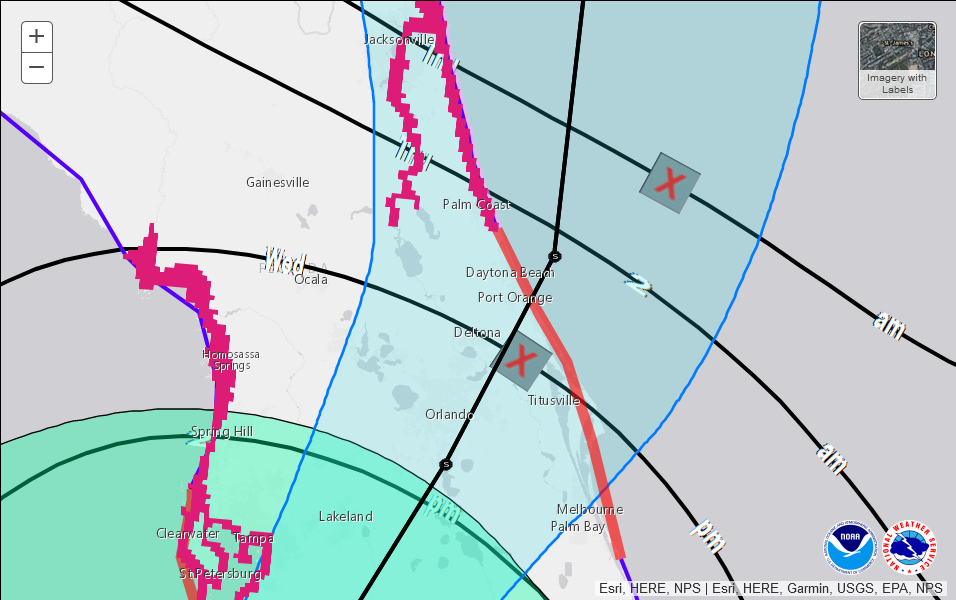
The late-blooming 2022 Atlantic Tropical Storm season is making up for lost time. A tropical system has developed in the Central Caribbean Sea. This storm system is forecast to threaten continental U.S. interests next week. While the tropical wave passed south of a key geographic area known as Hebert's Box #1, it will very likely pass through Hebert's Box #2. These boxes are useful as predictors of hurricanes that will strike South Florida. For more information about Hebert's Boxes, see Hebert Box. See graphic below which illustrated the Hebert's Boxes.
Mash the graphics below to enlarge. All links and images are self-updating.
his video feed went down and hasn’t returned...Reed Timmer..and hes a real pro at this stuff...
Yep, it looks like Fort Myers is taking the worst of it now other areas just appear to be really windy with no real storm surge.
:-) He’s in there now switching between Days of our Lives and The Beverly Hillbillies. We’re good, for now.

Sanibel and Fort Myers Beach are sadly being destroyed.
the guy running the cameras at severe-studios claims his number 7 camera in Sanibel is mounted 12 feet up....and they lost the feed half hour ago....Sanibel and Naples boy...i dunno...not good.
It’s down now
I’ve been watching weather channel but they haven’t said much about Sarasota’s since last night when it was almost guaranteed a direct hit. I’m guessing the worst hasn’t happened yet even thought we’re north of the eyewall?
just horrible stuff...lord.
Safe passage to you, your family, friends and neighbors through the storm. Hoping for the best.
My family has long association with Sanibel Island. My thoughts, as texted to my brother and sister just now:
Some positive notes...
An eyewall replacement cycle has left a gap in the most intense sections of the eyewall, which coincidentally (so far) has benefitted Sanibel as Ian moves ashore.
Further, the outer edge of the eyewall roughly coincides with Baileys. So far. It’s ragged, the storm is still intensifying, but the better the eastern half survives, the larger the footprint will be for staging post storm reconstruction, ON the island, after the causeway re-opens.
The general elevation of Periwinkle Way is around 20 meters. Although storm surge estimates have risen to 18 feet max, and winds in the (most intense parts of the) eyewall are near Cat-5, the foundation and much pavement of this primary artery have a good chance of survival.
Naples, so far, has only seen 4 foot surge, with tidal variance on track to top out around 6.
It’s not good. But it could be worse.
Once again, not official, not certain, just my best guesses.
Have a house in South Naples, may have to go down and check on it.
naples pier cam down now
downtown naples likely as well with a 5.5 ft storm surge and high tide yet to come. The naples pier was underwater before the cam went out
Thanks for your assessment.
Tampa Bay has had its water sucked out to the gulf by the storm’s extremely low barometric pressure and high westward winds, exposing the normally covered bay’s bottom (underwater rocky topography).
Charlie Kirk notes Newton’s Third Law of Physics to the reporter- Benny, that for every action there is an equal and opposite reaction.
All quite natural, and no liberal hand had anything to do with this, nor will they have any effect whatsoever on the storm’s course, yet dumb-dumb Amy Klobuchar, is being shown pleading for Democrats to be elected so that they can stop these types of hurricanes.
it took a bump to the North unfortunately....
hmmmm so demonrats control everything right now and yet still hurricanes. yeah more demonrat power is what we need /s
I’ll bet Resident Diddler will keep FEMA from helping out Gov. DeSantis.
Disclaimer: Opinions posted on Free Republic are those of the individual posters and do not necessarily represent the opinion of Free Republic or its management. All materials posted herein are protected by copyright law and the exemption for fair use of copyrighted works.