
Posted on 10/05/2020 5:44:03 AM PDT by NautiNurse
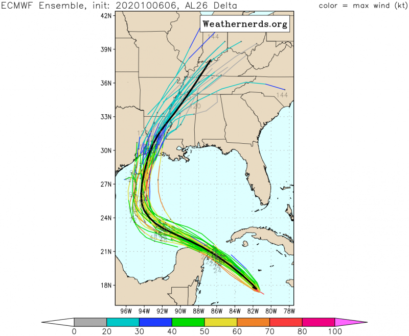
The 2020 Atlantic Hurricane epidemic continues for the Gulf of Mexico. Delta is currently forecast to reach hurricane strength in the Gulf of Mexico. Wearily and warily, we are once again looking at potential dueling storms in the Gulf of Mexico. There is a possibility we witness a Fujiwhara effect between Delta and Gamma. Delta is expected to be the dominant storm system. Meanwhile, Gamma moved much further northeast than previously anticipated.
Mash the graphics below to enlarge. All links and images are self-updating.
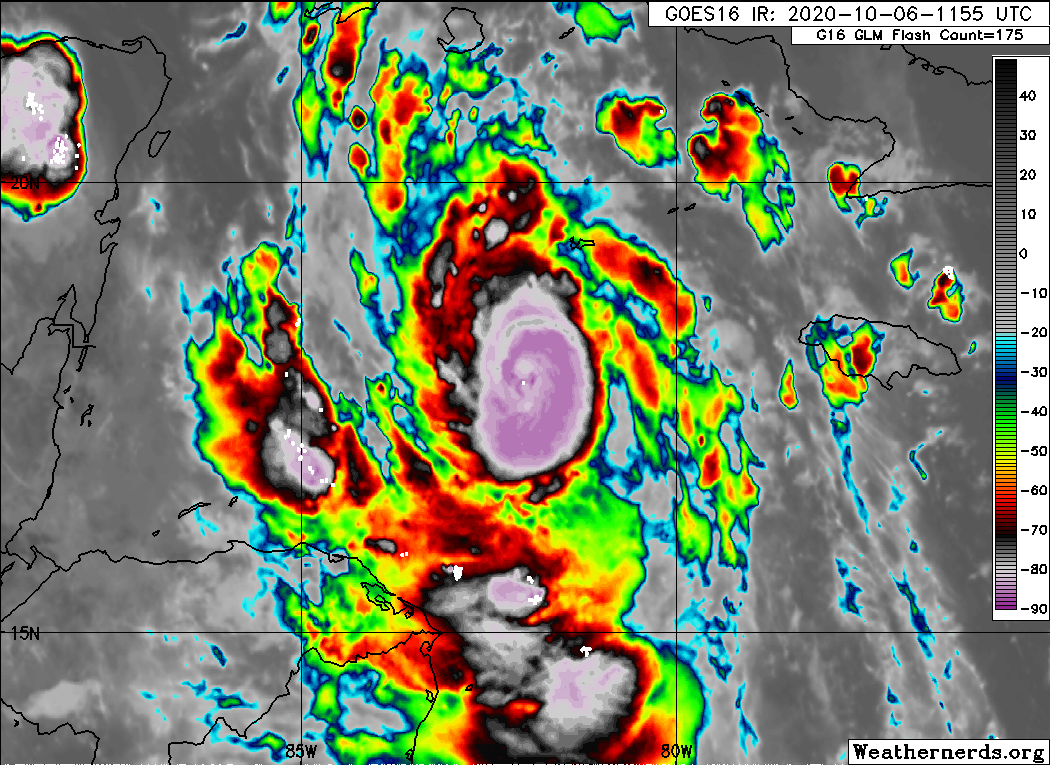
Location...About 420 MI ESE of Cozumel Mexico
...About 125 MI S of Grand Cayman
Max Sustained Winds...100 MPH
Moving...WNW at 15 MPH
Minimum Pressure...968 MB
Hurricane-force winds extend outward up to 25 miles from the center of the storm.
Tropical-storm-force winds extend outward up to 90 miles.

On/Off Hurricane List Mash Here--> 
Thanks for the ping!
LA looks to be in the path of this nasty storm. Stay safe!
Hurricane-force winds extend outward up to 25 miles from the center of the storm.
Tropical-storm-force winds extend outward up to 90 miles.
Right between Hwy 90 and I-10. What is your flood risk in your area?
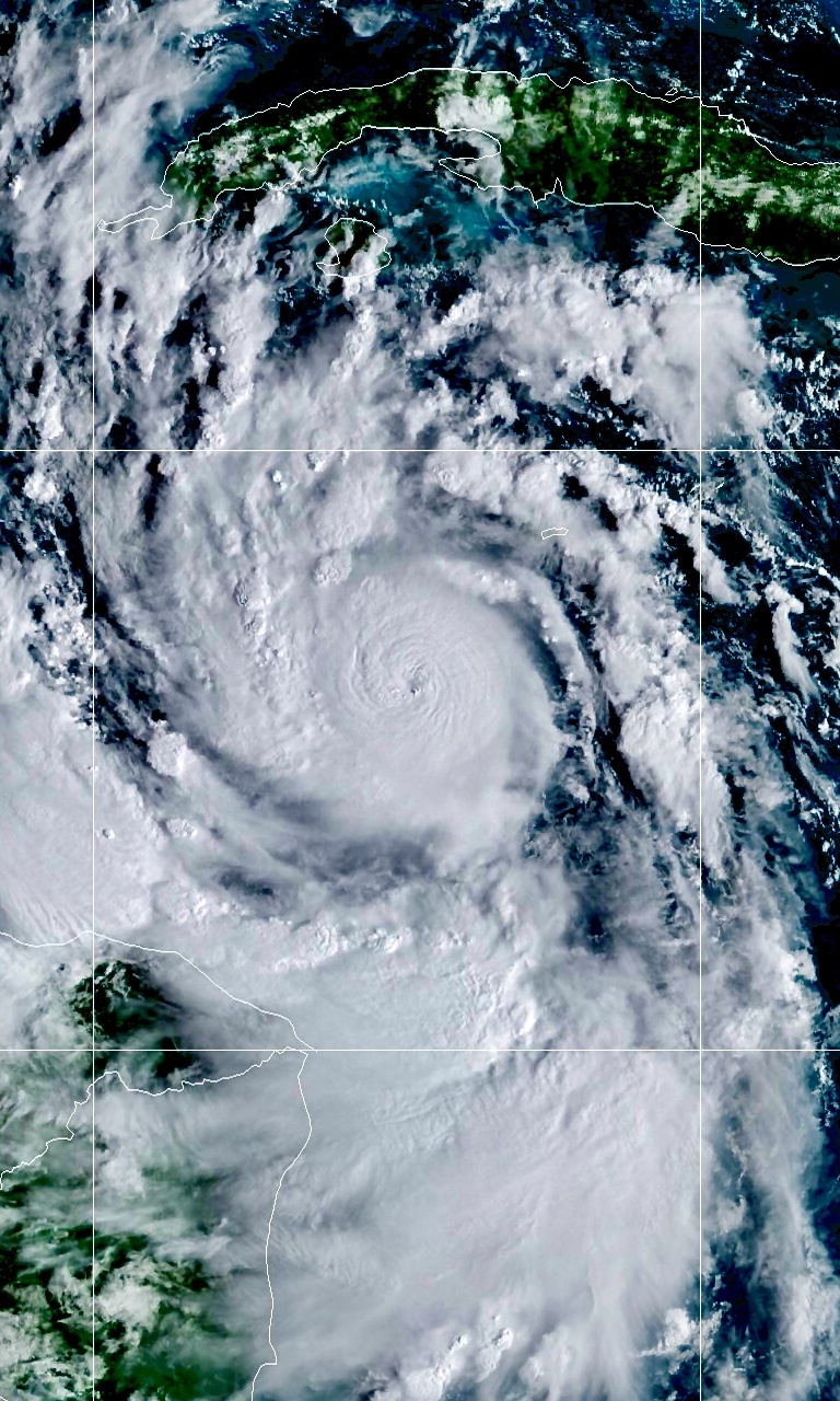
Amazing to see Gamma is still affecting things well past NHC signing off for Gamma updates.
I hate it when you have to rely on a last minute turn to the north to save your butt.
Bastardi saying Delta could hit CAT 5 for a period of time before decreasing intensity once it hits cooler water prior to landfall.
That brings the winds down but the tropical tidbits guy says, “the ocean has a long memory” meaning the higher category storm surge will continue to be pushed ahead of the eye at landfall.
Bump ((((Hugs))))
Yeah, we saw that with Ike. Ike was a cat 2 but it had a cat 4 surge.
Katrina was Cat 3 at landfall with Cat 5 surge. That is a function of large windfield hurricanes that weaken - all that water stays in motion.
Mrs. Augie and I are vacationing in Panama City Beach this week. We were supposed to be in Pensacola Beach, but Sally wrecked those plans.
Looks like we may need to bug out a day early.
I’m not hip to the idea of driving all the way across ‘bammer in a monsoon.
Now a Cat 3 as of the 11am NHC advisory.
yeah, I am not liking the Euro at all. But as long as I stay on the “good” side I’ll be OK. Rita got pretty close to me too, but happily I was on the “good” side so all I got was 50-60 mph winds for a couple of hours. I had the town just about all to myself since just about everyone here evacuated. I kept my beer joint open for the dozen or so folks that were here.
Location...About 320 MI ESE of Cozumel Mexico
...About 120 MI S of Grand Cayman
Max Sustained Winds...115 MPH
Moving...WNW at 16 MPH
Minimum Pressure...968 MB
Hurricane-force winds extend outward up to 25 miles from the center of the storm.
Tropical-storm-force winds extend outward up to 90 miles.
On/Off Hurricane List Mash Here-->
Disclaimer: Opinions posted on Free Republic are those of the individual posters and do not necessarily represent the opinion of Free Republic or its management. All materials posted herein are protected by copyright law and the exemption for fair use of copyrighted works.


