Free Republic
Browse · Search
News/Activism
Topics · Post Article

Skip to comments.

If Oroville Dam Failed, Residents Likely Would Not Be Advised in Time
Fox News ^ | February 19, 2017

Posted on 02/19/2017 2:05:36 PM PST by nickcarraway

Communities immediately downstream of California's Lake Oroville dam would not receive adequate warning or time for evacuations if the 770-foot-tall dam itself — rather than its spillways — were to abruptly fail, the state water agency that operates the nation's tallest dam repeatedly advised federal regulators a half-decade ago.

Regulators at the time recommended that state officials implement more public-warning systems, carry out annual public education campaigns and work to improve early detection of any problems at the dam.

Six years later, state and local officials have adopted some of the recommendations, including automated warnings via reverse 911 calls to residents. But local officials say the state hasn't tackled other steps that could improve residents' response, such as providing routine community briefings and improving escape routes.

(Excerpt) Read more at foxnews.com ...


TOPICS: Extended News; Government; News/Current Events; US: California
KEYWORDS: california; dam; evacuation; evacuations; lakeoroville; oroville; orovilledam; residents
Navigation: use the links below to view more comments.
first previous 1-2021-4041 next last
To: nickcarraway

Example of ‘no notice’:

(Colusa County) Maxwell residents flee at 2am and eyes are watching Knight’s Landing

Town of Maxwell floods as worry about Oroville Dam shifts to creeks and canals

http://www.sacbee.com/news/weather/article133701629.html


21 posted on 02/19/2017 5:09:15 PM PST by blueplum ("...this moment is your moment: it belongs to you " President Donald J. Trump, Jan 20, 2017)
[ Post Reply | Private Reply | To 1 | View Replies]

To: nickcarraway

nick - I just saw the spillway on fox cable news. There seems to be very little water flowing down the spillway beyond the big hole. It seems to be all going into the hole and down the cut. I don’t know what this means but it didn’t look right. I thought they filled that spillway hole up with rock?


22 posted on 02/19/2017 5:12:35 PM PST by blueplum ("...this moment is your moment: it belongs to you " President Donald J. Trump, Jan 20, 2017)
[ Post Reply | Private Reply | To 1 | View Replies]

To: blueplum

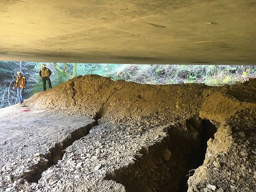
found a pix #19:
http://www.mercurynews.com/2017/02/19/oroville-dam-dramatic-photos-show-damage-to-dams-emergency-spillway/

23 posted on 02/19/2017 5:15:40 PM PST by blueplum ("...this moment is your moment: it belongs to you " President Donald J. Trump, Jan 20, 2017)
[ Post Reply | Private Reply | To 22 | View Replies]

To: blueplum
Oroville spillway isn't looking very functional today. Looks like 90% of the water is escaping.

.


24 posted on 02/19/2017 5:20:32 PM PST by Karl Spooner
[ Post Reply | Private Reply | To 21 | View Replies]

To: Karl Spooner
Ripped from WU:

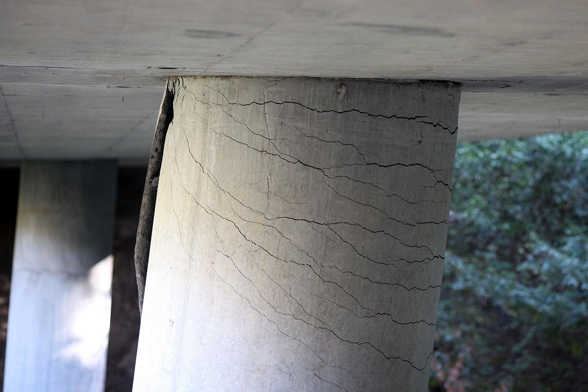
Pfeiffer Canyon Bridge along the Pacific Coast Highway (Rte.1) in Big Sur is being closed due to damage to its supports from a landslide, another result of heavy ppt in the area this rainy season.

25 posted on 02/19/2017 5:30:06 PM PST by txhurl (The LEFT are screaming at the Tsunami, and the Sky, trying to set fire to the Ocean- S.Tom)
[ Post Reply | Private Reply | To 24 | View Replies]

To: nickcarraway

Nothing to worry about, this is California, we have te Smartest People in the World running this State, just ask them.


26 posted on 02/19/2017 5:33:57 PM PST by eyeamok (destruction of government records.)
[ Post Reply | Private Reply | To 1 | View Replies]

To: txhurl

That’s a shocking photo of a most important bridge on PCH. Maybe our knowledgable Freepers can provide analysis.


27 posted on 02/19/2017 5:34:22 PM PST by The Westerner (Protect the most vulnerable: Replace all textbooks in the Humanities K-Post-Grad!)
[ Post Reply | Private Reply | To 25 | View Replies]

To: The Westerner

In centex, we went though a horrific 5yr drought, then two years’ flooding, which damages infrastructure changed by the dried-up soil, so we’re right there with CA, to a lesser extent.


28 posted on 02/19/2017 5:38:57 PM PST by txhurl (The LEFT are screaming at the Tsunami, and the Sky, trying to set fire to the Ocean- S.Tom)
[ Post Reply | Private Reply | To 27 | View Replies]

To: txhurl
Looks like a good solid foundation, too. They might be looking at years before it reopens, if it's even reparable.

.


29 posted on 02/19/2017 5:59:29 PM PST by Karl Spooner
[ Post Reply | Private Reply | To 25 | View Replies]

To: Karl Spooner

They have to wait until the rains stop, and everything dries out to shim it up.


30 posted on 02/19/2017 6:05:27 PM PST by txhurl (The LEFT are screaming at the Tsunami, and the Sky, trying to set fire to the Ocean- S.Tom)
[ Post Reply | Private Reply | To 29 | View Replies]

To: txhurl

This one? http://s24.photobucket.com/user/Davis1950/media/CALIFORNIA/IMG_0962_zpstx0lfuvm.jpg.html

One of my favorite places on earth.


31 posted on 02/19/2017 6:11:00 PM PST by combat_boots (God bless Israel and all who protect and defend her! And please, God, bless the USA again.)
[ Post Reply | Private Reply | To 25 | View Replies]

To: combat_boots

Closed Wed.


32 posted on 02/19/2017 6:26:28 PM PST by txhurl (The LEFT are screaming at the Tsunami, and the Sky, trying to set fire to the Ocean- S.Tom)
[ Post Reply | Private Reply | To 31 | View Replies]

To: txhurl

One of the most beautiful spots. An engineering marvel, too. Desolate. Magnificent. And at sunset, an absolute treasure. I hope many can see it in their lifetimes.


33 posted on 02/19/2017 6:31:19 PM PST by combat_boots (God bless Israel and all who protect and defend her! And please, God, bless the USA again.)
[ Post Reply | Private Reply | To 32 | View Replies]

To: txhurl
It's amazing the discripencies in the reporting. We go from shims to this.

"The north slope of Pfeiffer Canyon and the Pfeiffer Canyon Bridge itself are all poised to come down directly into the campground and into the path of foot traffic should we allow access.">

34 posted on 02/19/2017 6:31:19 PM PST by Karl Spooner
[ Post Reply | Private Reply | To 30 | View Replies]

To: Karl Spooner

I can’t tell if that massive boulder that slammed down on it shook the already drought-weakened soil at pier level, or how it happened.


35 posted on 02/19/2017 6:49:03 PM PST by txhurl (The LEFT are screaming at the Tsunami, and the Sky, trying to set fire to the Ocean- S.Tom)
[ Post Reply | Private Reply | To 34 | View Replies]

To: Karl Spooner

I can’t tell if that massive boulder that slammed down on it shook the already drought-weakened soil at pier level, or how it happened.


36 posted on 02/19/2017 6:49:03 PM PST by txhurl (The LEFT are screaming at the Tsunami, and the Sky, trying to set fire to the Ocean- S.Tom)
[ Post Reply | Private Reply | To 34 | View Replies]

To: nickcarraway

I fail to see how a state owned dam is a federal problem.


37 posted on 02/19/2017 7:54:32 PM PST by Blood of Tyrants (Conservatives love America for what it is. Liberals hate America for the same reason.)
[ Post Reply | Private Reply | To 1 | View Replies]

To: blueplum

The spillway is extremely compromised. I don’t know that their fixes helped in a significant way.


38 posted on 02/19/2017 8:54:18 PM PST by nickcarraway
[ Post Reply | Private Reply | To 22 | View Replies]

To: The Westerner

PCH? You must be from Southern California. They call it Highway 1.


39 posted on 02/19/2017 8:55:23 PM PST by nickcarraway
[ Post Reply | Private Reply | To 27 | View Replies]

To: Peter ODonnell
Actually, living under this dam (about 30 miles down stream), I only partially agree with your assessment... If you are in a flood prone area, you should be out of your home for this storm. Anywhere north of Fresno. But that has nothing to do with this dam.

First and foremost, if this dam completely fails as this article speculates, it will be because some significant and awful event took place. A massive earthquake that triggers some big slides that causes a pressure wave through the lake to take out the dam.

What is a worry is the auxiliary spillway, designed for one particular event and was tested with a far different one - which resulted exactly in how engineers said it would - significant erosion that would dig back towards the auxiliary spillway wall. There is a fair danger if they ever let conditions repeat that it would topple over and send about 25 feet of water right into the Feather River.

But not over the next few days. With the dam 50 feet below maximum, it is 20 feet below the lowest reach of the emergency spillway. That is, honestly, more than enough room to handle this storm. Even if the emergency spillway failed, it would take a combination of multiple events to threaten most people along the Feather River which was designed (and previously tested) to handle in excess of 360k cfps (that's 2.7 million gallons per second.)

And in my case, if the worst case were to happen, I've got 4 hours to get out of harm's way. And safety is 3 miles down the road.

As for notification, when they pushed the panic button in Oroville, our emergency services triggered the ‘code red’ system, a combination of app, e-mail, phone, and text notifications. Warning was sent to all residents within 3 minutes where I live.

40 posted on 02/19/2017 10:00:57 PM PST by kingu (Everything starts with slashing the size and scope of the federal government.)
[ Post Reply | Private Reply | To 19 | View Replies]


Navigation: use the links below to view more comments.
first previous 1-2021-4041 next last

Disclaimer: Opinions posted on Free Republic are those of the individual posters and do not necessarily represent the opinion of Free Republic or its management. All materials posted herein are protected by copyright law and the exemption for fair use of copyrighted works.

Free Republic
Browse · Search
News/Activism
Topics · Post Article

FreeRepublic, LLC, PO BOX 9771, FRESNO, CA 93794
FreeRepublic.com is powered by software copyright 2000-2008 John Robinson