Posted on 02/12/2017 4:26:47 PM PST by janetjanet998
Edited on 02/12/2017 9:33:58 PM PST by Admin Moderator. [history]
The Oroville Dam is the highest in the nation.
You know in the end the fix will be to just cover everything in a thick layer of concrete and re-bar.
Thanks.
Sounds like Juan is catching up on some of the things
we have been discussing here in the last few days.
One thing I heard new was the “Cyclopian Wall” plan.
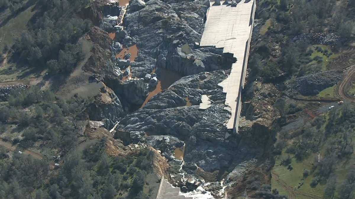
An engineering expert who visited the troubled Oroville Reservoir said this week that it would be nearly impossible for the state to complete temporary repairs to its fractured and eroded main spillway by a target date of Nov. 1.
In a report submitted to the Federal Energy Regulatory Commission this week, a panel of five independent consulting engineers warned that “a significant risk would be incurred” if the main spillway was not operational after October, which is the traditional start of California’s rainy season.
However, an engineering and risk management expert who was not part of the consulting panel told The Times this week that he doubted the state could meet such a close deadline.
“I think that is a challenging timeline,” said Robert Bea of UC Berkeley’s Center for Catastrophic Risk Management.
Bea, a retired civil engineering professor who led an investigation into failure of the New Orleans levee system after Hurricane Katrina, visited the reservoir recently to review inspection documents, as well as the report by the Independent Board of Consultants.
The consultants proposed that temporary repairs to the spillway be completed by Nov. 1, and that permanent repairs be completed after the rainy season.
In order to accomplish this, report authors said the Department of Water Resources should award grading contracts by March 31, complete design plans by mid-May and approve a construction contract by June 1. That would give the company five months to complete the work, the report suggested.
Bea said that schedule leaves little space for unanticipated problems.
http://www.latimes.com/local/lanow/la-me-ln-oroville-repair-timeline20170324-story.html
I don’t know if a link to this doc has been posted yet, but it mentions “cyclopean check dams”
https://www.ferc.gov/industries/hydropower/safety/projects/oroville/03-17-17.pdf
Thanks!
-
“Additional aspects of the short-term mitigation consist of the cyclopean backfill
placed downstream of the approximately 1,000-ft-long monolithic ogee weir section.
The weakest point in this plan occurs at the downstream end of the armoring where
all flows are directed and become channelized. To this end, DWR has placed small,
3-ft-high cyclopean check dams to slow the flow in these areas and control the
gradient. The knickpoints in these channels downstream of the check dams could be
problematic should future flows occur.
-
9
[This displays as page 5 of 16; the physical page number is 3]
[a knickpoint is part of a river or channel where there is
a sharp change in channel slope, such as a waterfall]


Whoever came up with the idea for a ramp so the flow could
jump across the gap should never be allowed to speak again.
If they just want to keep the water away from the break and avoid any undercutting erosion sure, but jumping the gap.... The impact of the uncontrolled water on the other side, the splashing.... yeah, it’s crazy! Chaos.

I’m pretty sure cyclops works for the State of California in some role...
Its looking like an "engineering political solution" is coming back to haunt the future. In the 1960's, rather than make the Original combined spillway design of 620,000 cfs work, the intervention of DWR's decision to split the combined spillway into two separate designs has forced a "lock-in" of the new "fixes" (see post link below). Yet another seeming "engineering political solution", possibly related to an expensive price tag, has the consequence of catastrophic destruction of a hillside triggering a "chain of events". This "chain of events" could lead to a swirling back flow that could erode the "toe" of the main dam, thus risking a failure collapse of the whole dam itself. This "failure mode" has been identified by a world renowned leading dam expert Scott Cahill. Scott identifies a dangerous erosion scenario that could cause the "loss of the Oroville dam" (via "eddy swirls" at the toe of the main dam).
The New "Board of Consultants (BOC)", of advising experts to DWR, has stated a requirement of restoration of the rated 646,000 cfs flood capacity of the combined spillway flows (see March 10, 2017 report below). HOWEVER, the new "upped" rating of a huge 396,000 cfs requirement of a new Emergency Spillway includes the caveat: "damage below the Emergency Spillway to be expected". This directly implies that there will be erosive damage. Given the known geology and the actual alarming erosion of "rotten rock" & debris from the last Emergency Spillway incident, the only method to prevent a repeat of this is to armor the hillside all of the way to the Feather River.
We will see how this "damage to be expected" is translated into a new design. Is the "damage" limited to the "armoring itself" or is it damage to an unconsolidated hillside further below an "armoring apron" (or both)? The latter is what could engender a very problematic sequence. (1) If the max rated 396,000 cfs destroys the hillside, a "dam" would form in the Feather River channel. (2) The main spillway chute is upstream, thus flows from the main spillway likely would "backflow" towards the "toe" of the earthen dam. (3) This backflow would form an "eddy swirl" at the "toe" terminus. (4) dangerous destabilizing erosion of the backside toe of the earthen dam would occur. (5) to prevent this "eddy swirl" or partially limit its intensity, the main spillway would need to be slowed or shut off. (6) Further erosion would occur from the Emergency Spillway handling "flood control". This is an inverse repeat of what is currently going on at the dam - BUT- with the exception of a lesser eddy back flow towards the dam (has since been mitigated by the excavation of most of the 1.7 million cubic yards of rock/debris.
The only clean design that "preserves the safety of redundancy" is by fully armoring the Emergency Spillway for the full length of the hillside to the Feather River. But the associated costs for this may become a difficult "political" funding issue.
…The 1960's DWR decision is still front and center today…
Expert panel of "Board of Consultants" requiring new Emergency Spillway to handle an upward revised 396,000 cfs down the hillside. "Damage Below the Emergency Spillway To Be Expected".

1. All of the remaining spillway is damaged or undermined beyond repair. There is just too much bad construction and damage to be sure that a patch job will not fail in the future.
2. I am very concerned about the main spillway gate structure. There is some limited information that it is weeping more than expected or designed to.
3. The e spill is a joke and needs to be seriously evaluated and dealt with.
I think the prudent course of action is the construct a new spillway - including a gate structure - adjacent to the existing one using modern techniques and design. This would allow the project to go through another wet cycle using the damaged system, in the meantime, if needed. Caisson pier system and pressure grouting the “bedrock” down to a 100 feet of so would stabilize the area significantly. Modern rebar specifications and concrete technology. They are not going to catch any breaks on this situation. The geology and past sins are an too big of a hill to climb
From the article :
“8. “The panel report also said that while touring the spillway, consultants spotted “extraordinarily large” amounts of water gushing out of drains designed to move water out from beneath the intact portion of the chute. The water was flowing even though the spillway’s gates were closed and it wasn’t raining,..””
Now, where would that water be coming from?
From under that rectangular object right behind the main spillway gates?
Hi WildHighlander57, You ask a great question - this reveals a Sac Bee reporter's "editing liberty" on the BOC report (..where would that water be coming from?).
The Sac Bee reporter edited wording from the BOC report which changes the context of what the inspectors actually observed. Without looking at the actual Board of Consultants report, the Sac Bee reporter's writing could let a reader think that "gushing" water was flowing all of the time - even when the gates were closed and it wasn't raining. Wrong. If you read the actual BOC report wording, the "gushing water" from the herringbone structure spillway underdrains is when the spillway is in operation. (i.e. NOT "gushing" when the spillway is shut down.). The BOC correctly concludes the origin of this "gushing" water as from cracks in the slabs and from seams in the slabs that are "collected" by the drains.
Another very important point the BOC identifies is that water is coming back "up" through cracks and spalls in the slab when a light flow is present along the sandbagged rerouted side of the spillway. This means that there is a "channel" that the water can flow under the drains (i.e. not collected by the drains) and resurface further down the spillway. They also note, very importantly, that "piping" is part of the process. This is the same as water "channeling" through paths under the spillway & is a "wash erosion" issue - thus the statement of "..seems likely that piping of foundation material beneath the chute slab may be responsible for the voids that have been found and repaired in the past." Bingo!! The spillway was emplaced upon erodable material - see post link below.
Now the most interesting part is the BOC statement: "The drains appear to flow for some appreciable time after the gates are closed and not precipitation is occurring".
For this condition to occur there has to be either a "pooling" of water in an elevation just above the spillway undersurface, or, a pressurized form of a rebound spring of subsurface water from below. I suspect it is the former. In this case, water could be penetrating out of the sidewalls into the backfill areas & chute hillside. It then would re-flow back towards the lowest point where the sub drains are located. ANY water that escapes outside of the chute area has foundation consequences over time. "Fines" of small material could migrate from the backfill areas and chute hillside, forming voids, pockets of water, and potential alternate "piping" routes outside of the chute. Not surprising that the BOC stated "The BOC believes this situation should be investigated".

That thought keeps running through my head.
My head too. New spillway, next o the damaged one. Then, maybe, a complete replacement of the damaged one so that it can serve as an emergency spillway instead of the present system of overtopping a wier.
Disclaimer: Opinions posted on Free Republic are those of the individual posters and do not necessarily represent the opinion of Free Republic or its management. All materials posted herein are protected by copyright law and the exemption for fair use of copyrighted works.