Posted on 02/12/2017 4:26:47 PM PST by janetjanet998
Edited on 02/12/2017 9:33:58 PM PST by Admin Moderator. [history]
The Oroville Dam is the highest in the nation.
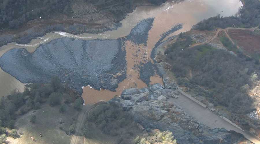
http://www.kcra.com/article/10-photos-show-extensive-damage-at-oroville-spillway/8987693This I think goes right to the pics...what a horrofic mess...55,000 dumptruck loads of debris at the bottom...
I hate to say, I toa’d you so, LOL.
I bet that a couple of trillion pounds of water hammered that out.
“...a suitable spillway bridge over that gap...”
-
I kind of like that idea, like an ancient Roman Aqueduct.
I guess we will see in time.
Repeal the 17th,
Thanks for the link fix!
Janetjanet998,
Check out these pics!
http://www.kcra.com/article/10-photos-show-extensive-damage-at-oroville-spillway/8987693
This gentleman has several exalent you tube videos about this. This link is from a couple of days ago explaining what had happened to that point and what they need to do including getting the power house functioning again. Well worth watching the whole 17 minutes.
https://www.youtube.com/watch?v=Nrz-U1yxOWM&t=923s
This is the latest update, https://www.youtube.com/watch?v=9lmYJAg3Evs BVB
Good stuff, thanks!
Response to query on another thread…. Sorry for the length of this info & image sizes. This is important information to share.
News station KCRA had an important "slight reveal" (re: DWR comment) from a short clip in an article: Titled: "IS THE EMERGENCY SPILLWAY FIXED?"
http://www.kcra.com/article/dwr-begins-decreasing-oroville-releases-to-zero/8985871
= = KRCA excerpt:
"IS THE EMERGENCY SPILLWAY FIXED?"
"As for the emergency spillway, crews have continued to “armor” the base that was eroded away when the lake exceeded full capacity. Water officials are making sure it is ready to go in the event that it would be needed."
"DWR hopes that won’t happen since there isn’t a way to test that until it is actually needed."
= = = end excerpt
KEY emphasis: "DWR hopes that won't happen since there isn't a way to test that until it is actually needed."
What could go wrong? (i.e. what to insure does not happen): If a severe "overtopping" event occurs again, A potential "V" breach could initiate simply from water "head force pressure" via "pushing" the Spillway aside[3][5] or even "toppling" the Spillway[5] - as the Espillway is held down mainly by its own weight. Here are the factors that come into play:
The "backside armoring" of the footing provides an improved anchoring against any sliding. However, if there is any erosion or cracking of this backside armoring, a penetrating erosion of the bench excavation [4] near the backside shell foot could cause a "shifting" and a "toppling" risk [5]. Water could penetrate this structure from below and from seams [6] which changes the slippage adhesion (shear friction). New "fixes" have created a new problem for the "drains" - water could be channeled back under if ES overtopped [7].
Head water pressure, if it finds a seam in the "rotten rock", could create a potential subsurface erosion under the "armoring". If overflow turbulence on the topside of the "armoring" happens in conjunction with a from of a boil seepage flow "under the armoring", a swift crack may develop - leading to swift "back erosion" heading to the footing of the ES (topple & shift risk) [3][4][5].
How Deep could the "V" breach go? From the deep gash erosion of the "fractured/weathered rock layer", a repeat of the turbulence at this location could result in a 107ft differential from 901ft [4]
Wouldn't a "V" breach just eat away at the Emergency Spillway hillside? Yes. However, the Main Spillway Head structure is adjacent to the Emergency Spillway. A 107ft differential down to 794ft could result in four outcomes: (1) erosion will cut back into the water side of the spillway - which includes near the apron to the main spillway. (2) erosion could create vortices that cut towards the backside of the main spillway chute. (3) Original construction Engineers are aware that there are "of a lower quality rock than anticipated" in seams in the upper main spillway (stated in archives: special grouted pig tail anchors & chain link surface covering used to shore this up)[8]. (4) Aggressive "back erosion" could reach the footing of the Weir could result in sections to "topple" or cause sections to "slide".
Any of these four could disable the main spillway (either by resulting in non-laminar input flow turbulence (deep "V" erosion in/near apron), or a structural integrity loss/compromise of the upper main spillway).
Any set of these reasons could be why there is such a concern regarding the Emergency Spillway. Hopefully there will not be a hard "test" of these "uncertainties" from another overspill condition (severity & duration).
Important note: This data was derived from the inspection and analysis of Oroville archives, reports, news information, actual erosion results, historic information, forum engineering failure analysis discussions, and more. Unpublished engineering data may alter this "perspective analysis discussion".
Detailed engineering information - reveals potential failure "concerns" (regarding ES issues/uncertainties).
note: points below refer to the 930ft section of the Emergency Spillway.
1. The Emergency Spillway is not solid concrete (it is an upside down half "shell" of concrete that is filled with material such as aggregate).
2. The Emergency Spillway construction height is higher that what is stated in articles/news. It is 64ft at its highest. (where it abuts the Main Spillway Head Structure - from the bottom of the concrete foot (837ft elev) to the peak (901ft elev)).
3. The ES was designed to "not shift" mainly from "gravity" (its own weight). It is not anchored. It simply sits upon a flat excavation called a "bench excavation".
4. The "bench excavation" foundation is "weathered rock" or "fractured rock" (some refer to this as "rotten rock"). This material exhibited an astonishing rate of erosion from the first spillway overtopping (deepest: 36ft gash down to elev 794ft - besides other deep & wide erosion cuts).
5. Thus, the ES has a design that must insure it won't "topple over" or "slip off of the flat surface it rests upon" (overturn & shear friction).
6. The ES has water drains inside the "shell" to drain any water penetration into the aggregate fill (from seams, minor cracks, or from under the footing capillary action).
7. "Half pipes" installed at the drains before grouting may "channel" water into and under both the armoring and could interfere (back-up) drainage of the aggregate.
8. Upper Main Spillway Chute: found areas that “proved to be of a lower quality rock than anticipated. There were several large seams running parallel with the chute. The planned anchor bars were replaced with grouted rock bolts, pigtail anchors, and chain- link surface covering in that area”
9. Finite Element Analysis was done on the Main Spillway solid concrete structure. The models did not include any side anchor model references to the Emergency Spillway in their simulations. (no mention of Emergency spillway nor Auxiliary in extensive 710 page Earthquake analysis report).
(State of California Department of Water Resources, The August 1, 1975 Oroville earthquake investigations, Bulletin 203-78, February 1979).
1. The Emergency Spillway is not solid concrete (it is an upside down half "shell" of concrete that is filled with material such as aggregate). 6. Blueprint Shows "drains" & internal drain collector. note: "box" drains are 48sq inches in opening size.

2. The Emergency Spillway construction height is higher that what is stated in articles/news. It is 64ft at its highest. (where it abuts the Main Spillway Head Structure - from the bottom of the concrete foot (837ft elev) to the peak (901ft elev)).

3. The ES was designed to "not shift" mainly from "gravity" (its own weight) - Gravity Ogee Weir. It is not anchored. It simply sits upon a flat excavation called a "bench excavation". btw- the archive report statement of 50ft reference is from extracting construction blueprint scale dimensions. Actual construction to the Main Spillway Head Section required a higher footing section to 64ft.

4. The "bench excavation" foundation is "weathered rock" or "fractured rock" (some refer to this as "rotten rock"). This material exhibited an astonishing rate of erosion from the first spillway overtopping.

5. "Both weir sections were checked for overturning and shear friction safety factor and found to be satisfactory". WE now know this is not accurate. Simply "aggressive" back erosion to the foot of the Weir could have initiated either a topple or shear condition.

7. "Half pipes" installed at the drains before grouting may "channel" water into and under both the armoring and could interfere (back-up) drainage of the aggregate.

9. Finite Element Analysis was done on the Main Spillway solid concrete structure. The models did not include any side anchor references to the Emergency Spillway in their simulations. Analysis would have been inaccurate if the ES was anchored to the Main Spillway Head Structure.

(maggief OP)
The Los Angeles Times revealed a stark dichotomy in "before" and "after" statements by DWR concerning their engineering assessment & lack of awareness of critical design aspects of the Emergency Spillway. DWR should not have been surprised that the ES was not anchored. It is in the design construction blueprint drawings and described as a "gravity ogee weir" in the construction/design archives. DWR also should have been aware of the geology + construction reports specifically noting "lower quality rock than anticipated" in areas of the "saddle region" - thus, the inaccuracy of stating "Solid Rock" at the Feb 11 briefing.
= = Article Title:
"Government severely misjudged strength of Oroville emergency spillway, sparking a crisis"
http://www.latimes.com/local/california/la-me-oroville-spillway-failure-20170216-story.html
Before (at Feb 11 briefing): = = excerpt:
"Bill Croyle stood in front of an aerial photo of Lake Oroville and swept his hand across the top of the emergency spillway that was helping drain water out of the brimming reservoir.
“Solid rock. All this is rock,” Croyle, acting director of the Department of Water Resources, said with an air of confidence at the Feb. 11 briefing.
....
"Some 27 hours later, state officials told Butte County Sheriff Kory Honea that erosion was chewing away at the base of the spillway’s concrete lip. It was on the verge of collapse, threatening to send a towering wall of flood water surging through downstream communities, endangering tens of thousands of people. Honea ordered a mass evacuation."
...
"Interviews and records suggest that the near-catastrophe grew out of fundamental problems with the original design of the emergency spillway that were never corrected despite questions about its adequacy."
...
"The concrete weir at the top of the emergency spillway was “just plopped on top of that ridge." ...
"Vogel confirmed that the weir, which she said ranges in height from 25 feet to 45 feet, was not anchored."
...
= = end excerpts
It should be noted that the article states "soft rock" where as the rock is "highly fractured hard rock". There is an important difference in the different erosion characteristics & swiftness of erosion (fractured chunks breaking off verses small pieces eroding at a different pace via hydraulic turbulence).
It’s a long discussion thread, but there is a lot of good information and drawings linked within, all pertaining to the dam...
https://www.metabunk.org/oroville-dam-spillway-failure.t8381/
Hi Meyer, Yes it is a respectable discussion forum with many experienced contributors. Even in disagreement, their discussion is technical and demeanor is cordial.
The aloofness and arrogance of big government is breathtaking, and yet we continue to put in their hands what private enterprise, small government, and reasonable accountability could do so much better.
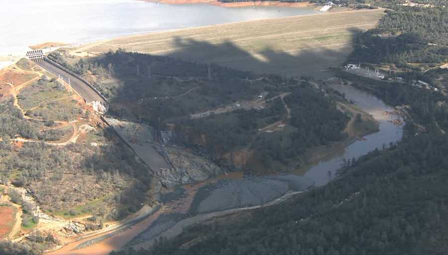
The local Fox station showed new photos and videos of what the former spillway looks like now.
In summary, it appeared be a total disaster and the debris below it looked like a rugged moonscape or bombed area.
Thanks ER for the update and thanks you Bob for the video updates and https://www.youtube.com/watch?v=9lmYJAg3Evs by Juan Brown (?).
What pops out at me from all of this is
1) The Main Spillway damage is so gargantuan that until the rainy season is over, if the Main Spillway is needed, it will continue to move earth and rock into the middle of the river below and back it up into the power plant. I mean even remedial repair looks like it would take weeks or months to fix that problem. I don’t know exactly what they plan to do in the next seven days. I don’t know how long a permanent fix would take.
2) The Emergency Spillway looks more threatening to cause a catastrophic emptying of the reservoir and flooding from its failure. Maybe the whole Emergency Spillway design needs an overhaul including the un-anchored upside-down half shell at the top. Have no idea how long that could take.
Is it possible that the time to do the job right on these spillways could take more that one summer season? If so, couldn’t that change the priorities of what the do first to reasonably hold off a problem next winter and finish the job the following summer?
With so much debris in the river, has any briefing information revealed the timeframe they expect to clear it? And the excavation strategy?
Carving a narrow slot or narrow channel through the debris may facilitate the quickest path to lowering the river. But a narrow channel could be at risk of filling again if they have to open the spillway at higher cfs levels again.
I guess we’ll have to wait and see.
btw- At the latest briefing it was stressed that any airspace violations by private drone operators could threaten the whole schedule. (I’ll bet there are hunters that would volunteer to help them on this... high tech flying clay pigeons).
No predictions just incredible shots of the debris below the spillway and the damage we can see.
The good news is no rain until this weekend, and some very cold weather in that area to prevent snow melt.
Not sure of the snow levels above Oroville dam. Some of the snow levels in the Tahoe skiing area are very very high.
I remember sometimes a lot of snow in those areas into early June in some years.
In some years we have hot temps starting about Mother’s days in that area and not decreasing until the fall.
I hate to say, I toa’d you so, LOL.
I bet that a couple of trillion pounds of water hammered that out.
Great Pic !
You know, filling in the hole and fixing the spillway below the main break is not the most important issue on the spillway.
Prioritizing it to me would be like this:
1a) Clear the river of a lot of the debris. Couple of big clam shell passing it to track excavators just to get it out of the river bed, simultaneous with —
1b) Cut a new pathway for water below the break that would not continue to add as much debris to the river channel.
1c) Get above the break with maintenance vehicles and crews and make all repairs to the slab areas above the break. If the spillway has to be put back into action, we need a spillway that will not have its concrete surface break up above the current break and create an entire new source of debris and sub terrain damage.
2) After those items are address simultaneously, then move to cutting out the canyon ( I think I will name it Moonbeam Canyon ) and benching it back for engineered fill considerations. If in mucking it out, it is found to be unable to get back to some bedrock, then consider an engineered drop and eliminate the rock mountain below Moonbeam Canyon.
Disclaimer: Opinions posted on Free Republic are those of the individual posters and do not necessarily represent the opinion of Free Republic or its management. All materials posted herein are protected by copyright law and the exemption for fair use of copyrighted works.