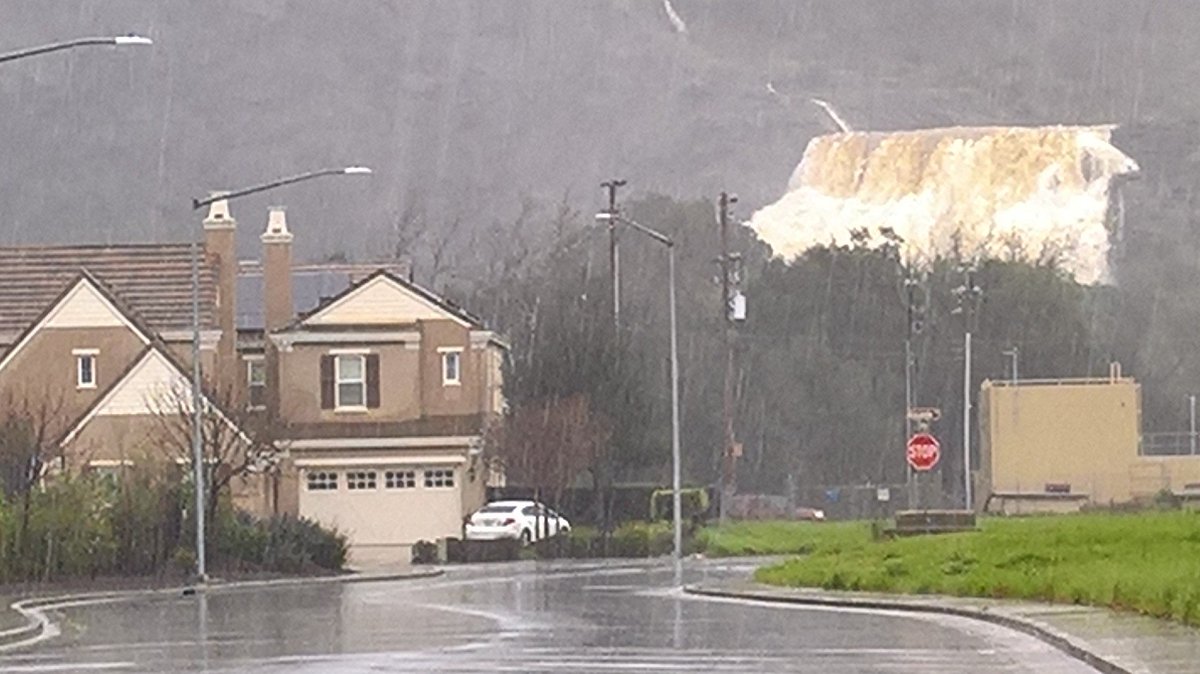
Len Ramirez @lenramirez 58m58 minutes ago
Yes, that's a waterfall behind the house. Anderson dam spillway in full force now. #CaliforniaStorms @CBSSF
Posted on 02/12/2017 4:26:47 PM PST by janetjanet998
Edited on 02/12/2017 9:33:58 PM PST by Admin Moderator. [history]
The Oroville Dam is the highest in the nation.
I don’t know when or where #1613 was taken, but yesterday I heard on the scanner that clearing was underway on MS gates #2, 3, and 6.
Check out outflow/inflow at Shasta Dam!
http://cdec.water.ca.gov/cgi-progs/queryF?s=SHA&d=20-Feb-2017%2014:19&span=12hours

Len Ramirez @lenramirez 58m58 minutes ago
Yes, that's a waterfall behind the house. Anderson dam spillway in full force now. #CaliforniaStorms @CBSSF
From the piece you linked/excerpted :
~snip~DWR officials were preoccupied with the situation at Oroville and unavailable for comment on how they manage Antelope Lake. “I don’t even know where that reservoir is,” said DWR spokesman Chris Orrock~snip~
Ahhhh me....the unaccountable life.
Oroville video:
https://m.facebook.com/story.php?story_fbid=10154965702387889&id=71781612888
Accu Weather was live 4 hrs ago.
Yikes!
Uhmmm..not good.
If I was Len I’d be seriously investigating ...
https://twitter.com/lenramirez/with_replies
Len Ramirez
@lenramirez
KPIX 5 Multimedia Journalist. As seen on TV.
San Jose/Silicon Valley • KPIX5.COM
If I was Len I’d be seriously investigating ...
https://twitter.com/lenramirez/with_replies
Len Ramirez
@lenramirez
KPIX 5 Multimedia Journalist. As seen on TV.
San Jose/Silicon Valley • KPIX5.COM
.
Anderson doesn’t have a particularly large watershed behind it, nor does that watershed have any snow pack to melt.
Not a likely place for any crisis.
.
https://www.periscope.tv/EmilyBertolino/1yoKMegPpPWKQ
Views of the Oroville Spillway as crews prepare to remove debris from diversion pool #OrovilleDam #OrovilleSpillway
 In 66288
Out 19147
I had to double check to be sure the figures weren't reversed.
Once the insurance company sees that photo they’re gonna reassess coverage on that house.
Well sure. It’s “waterview” property now!
https://twitter.com/LauraAnthony7/with_replies
Laura AnthonyVerified account
@LauraAnthony7
ABC7 News reporter
abc7news.com
@StanSheriff “We strongly urge” people to evacuate in low-lying areas near #TuolumneRiver as #DonPedro spillway set to open. Not mandatory.
#BREAKING Officials will open #DonPedro spillway at 3pm. First time since 1997 in flood conditions. Will spill for at least 4 days. #ABC7now
#DEVELOPING #TuolumneRiver already running fast and high in @cityofmodesto Could go up another 5 feet here after #DonPedro spillway opens.
#DEVELOPING Residents heading out...along Tuolumne River. Officials do expect to open #DonPedro spillway at approx 3p, first time since ‘97.
#BREAKING Police going door to door evacuating residents along Tuolumne River in prep for expected opening of Don Pedro spillway.
Save that Shasta data!
Prayers UP!!!
That run-off is going about 1500 feet and running under a small bridge on 101. Could be fun at 101 come rush hour.

Here is the Shasta Table;
They have lowered Shasta about 10 feet in the last 10 days. The latest is here
https://cdec.water.ca.gov/cgi-progs/queryDaily?SHA
maggief wrote:
“Oroville video:
https://m.facebook.com/story.php?story_fbid=10154965702387889&id=71781612888
Accu Weather was live 4 hrs ago.”
Thanks for that info, maggief !
@ 0:40 & about 1:20 or 1:43 at the bottom, no water is going on the main spillway... it’s all going to the right, cutting a canyon there.
Disclaimer: Opinions posted on Free Republic are those of the individual posters and do not necessarily represent the opinion of Free Republic or its management. All materials posted herein are protected by copyright law and the exemption for fair use of copyrighted works.